Area Overview for NG9 1NX
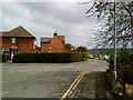
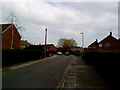
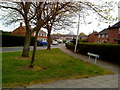
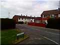
Photos of NG9 1NX


Area Information
Living in NG9 1NX offers a specific residential experience within a compact footprint of 1.4 hectares. This postcode covers a small residential cluster where 1,789 people call it home. Despite its limited size, the area hosts a high population density of 123,809 people per square kilometre, creating a tightly knit neighbourhood feel. The area is primarily defined by its housing structure, which consists largely of houses rather than apartments. For residents, daily life involves navigating a space where community proximity meets a concentrated living environment. You will find that this location serves as a functional home base, situated near key transport hubs and local amenities. The layout supports a lifestyle where neighbours live close by, yet the area maintains distinct residential characteristics. When considering homes in NG9 1NX, you are looking at a specific postcode area that balances urban convenience with a defined residential identity. The immediate surroundings offer practical access to stations and shops, ensuring that essential services are within practical reach without the sprawl of larger districts. ### The community in NG9 1NX reflects a mature population profile with a median age of 47 years. The most common age range extends from adults aged 30 to 64 years, indicating a neighbourhood settled by established households. This age demographic suggests a crowd that values stability and long-term residency in their homes. Home ownership stands at 62 per cent, a figure that reinforces the area's status as a predominantly owner-occupied sector rather than a rental market. The majority of the population identifies as White, shaping the cultural fabric of this locality. With 62 per cent of residences owned outright, residents often exhibit a deep connection to their specific properties. The concentration of adults in their 30s through to mid-60s creates an environment where daily routines involve school runs for younger children, career focus for middle-aged workers, or retirement planning for older residents. The high density contributes to a bustling social atmosphere despite the small area size. You will find that the demographic makeup prioritises family unit formation and sustained community engagement over transient living patterns. ### The property market in NG9 1NX is defined by a strong presence of house ownership. With 62 per cent of homes currently owned by their residents, the area functions as a significant allocation of owner-occupied properties. This statistic indicates that the local housing stock comprises established households rather than short-term rentals dominated classes. The accommodation type is exclusively houses, meaning you will not find apartments or flats within this specific cluster. This structure caters specifically to families or individuals seeking individual garden space and traditional residential layouts. When searching for homes in NG9 1NX, buyers should expect a market focused on detached, semi-detached, or terraced housing suitable for permanent settlement. The high home ownership rate suggests steady property values and a stable local economy supporting long-term investment. There is a clear distinction between this area and high-density urban developments where rental yields often dominate. Instead, the scarcity of available stock compared to the high demand from locals creates a competitive environment for genuine buyers. You are entering a market where properties change hands less frequently than in transient city centres, reflecting a community built on roots rather than opportunity. ### Families living in NG9 1NX benefit from immediate access to highly rated educational institutions. Beeston Rylands Junior School serves the primary education needs of younger children and holds a Good rating from Ofsted. This school provides a solid academic foundation within the local cluster. Nearby, Trent Vale Infant School also operates with a Good Ofsted rating, offering care and early education for the younger age groups. The presence of two consecutively rated Good primary schools ensures that children in the area receive quality instruction without needing to travel far. This mix of primary options is particularly valuable given the surrounding neighbourhood's age profile, which includes many adults in the 30 to 64-year range. Homes in NG9 1NX are well-positioned relative to these educational facilities, making the daily commute to school manageable. The data confirms that these schools are the primary local options listed, so prospective parents can plan based on these specific providers. Both institutions demonstrate a commitment to educational standards that supports the community's stable demographic. ### Digital connectivity for residents of NG9 1NX is robust and supports modern working lifestyles. Fixed broadband quality scores 98 out of 100, placing the area among the top tier for internet speed and reliability. This excellent fixed broadband rating means you will enjoy fast downloads and stable connections ideal for working from home. Mobile coverage scores 85 out of 100, indicating a very strong signal that supports seamless communication throughout the day. When considering homes in NG9 1NX, you can rely on a digital infrastructure that rarely drops. A broadband score of 98 suggests coverage is nearly perfect, eliminating the need for additional network boosters or satellite solutions. The mobile network provides sufficient data speeds for streaming, video calls, and real-time collaboration tools. For professionals who depend on digital tools for their daily tasks, this connectivity level removes a common barrier to living in specific residential zones. The reliable nature of these services ensures that you remain connected even during peak usage times in the local network. ### Residents of NG9 1NX enjoy convenient access to a variety of amenities within practical reach. For rail travel, five stations are nearby, including Beeston Railway Station, Attenborough Railway Station, and Nottingham Railway Station. These hubs facilitate easy commutes into the city and beyond. Retail options are also abundant, with five key locations serving shoppers. Co-op Queens and Co-op Beeston offer everyday essentials close to home, while Tesco Nottingham provides larger store formats for broader needs. Public transport connections are strong, with access to five metro-linked points such as the Tram and Bus Interchange, Beeston Centre Tram Stop, and Chilwell Road. One airport, Nottingham Airport, sits near this cluster for those requiring air travel flexibility. You will find that dining and shopping experiences are integrated into the local transport network, reducing the need for lengthy commutes to the city centre. The proximity to Co-op and Tesco venues ensures that grocery runs are quick and convenient. This combination of rail, bus, and retail nodes creates a lifestyle where daily tasks are handled efficiently without relying solely on personal vehicles. ### Safety and environmental factors in NG9 1NX present a clear picture of risk and protection. The area faces a critical flood risk, rated at a score of 39.14 on a scale where lower numbers indicate less danger. This critical level signifies a high flood risk coverage that requires внимания to local drainage and property siting. However, the area passes its assessment for Ramsar wetland sites, polling a score of zero risk. This means there is no Ramsar wetland coverage that could complicate planning or create ecological restrictions. Similarly, the area passes tests for Areas of Outstanding Natural Beauty, Protected Nature Reserves, and Protected Woodland, all scoring zero risk. A score of zero confirms there are no protected natural constraints limiting future development or usage rights. Regarding public safety, crime risk assessment rates as Pass with a score of 78 on a 100-point scale. The description notes low crime risk and below-average rates compared to other regions. The safety score of 78 indicates a generally secure neighbourhood where residents feel protected from criminal activity. You should balance the critical flood risk with the low crime score when evaluating this location for long-term security. ### What is the demographic profile of NG9 1NX?The area has a median age of 47, with most residents falling between 30 and 64 years old. Home ownership is high at 62 per cent, and the predominant ethnic group is White. This stable population structure supports a community focused on established households rather than transient lifestyles. Which schools are available near NG9 1NX?Families have access to Beeston Rylands Junior School and Trent Vale Infant School. Both institutions hold a Good rating from Ofsted, ensuring quality education for children living in this postcode area. These primary schools are the main local options for education. How good is the transport connection in NG9 1NX?Digital infrastructure is excellent, with fixed broadband scoring 98/100 and mobile coverage at 85/100. Five rail stations nearby include Beeston and Nottingham Railway Station, while five metro-linked transport points offer easy access to bus and tram networks. Are there any safety concerns I should know about?The area has a low crime risk with a safety score of 78/100, indicating it is safer than average. However, it faces a critical flood risk rated 39.14/100. Planning constraints regarding nature and woodland are minimal, with zero risk scores for Ramsar sites and AONB coverage. What amenities can I access while living in NG9 1NX?Residents are within reach of five rail stations, five retail outlets including Co-op Queens and Tesco Nottingham, and five metro-linked stops. Nottingham Airport is also available for travel needs, making this a connected location for shopping and commuting.
- Area Type
- Postcode
- Area Size
- 1.4 hectares
- Population
- 1789
- Population Density
- 4109 people/km²
The property market in NG9 1NX is defined by a strong presence of house ownership. With 62 per cent of homes currently owned by their residents, the area functions as a significant allocation of owner-occupied properties. This statistic indicates that the local housing stock comprises established households rather than short-term rentals dominated classes. The accommodation type is exclusively houses, meaning you will not find apartments or flats within this specific cluster. This structure caters specifically to families or individuals seeking individual garden space and traditional residential layouts. When searching for homes in NG9 1NX, buyers should expect a market focused on detached, semi-detached, or terraced housing suitable for permanent settlement. The high home ownership rate suggests steady property values and a stable local economy supporting long-term investment. There is a clear distinction between this area and high-density urban developments where rental yields often dominate. Instead, the scarcity of available stock compared to the high demand from locals creates a competitive environment for genuine buyers. You are entering a market where properties change hands less frequently than in transient city centres, reflecting a community built on roots rather than opportunity. ### Families living in NG9 1NX benefit from immediate access to highly rated educational institutions. Beeston Rylands Junior School serves the primary education needs of younger children and holds a Good rating from Ofsted. This school provides a solid academic foundation within the local cluster. Nearby, Trent Vale Infant School also operates with a Good Ofsted rating, offering care and early education for the younger age groups. The presence of two consecutively rated Good primary schools ensures that children in the area receive quality instruction without needing to travel far. This mix of primary options is particularly valuable given the surrounding neighbourhood's age profile, which includes many adults in the 30 to 64-year range. Homes in NG9 1NX are well-positioned relative to these educational facilities, making the daily commute to school manageable. The data confirms that these schools are the primary local options listed, so prospective parents can plan based on these specific providers. Both institutions demonstrate a commitment to educational standards that supports the community's stable demographic. ### Digital connectivity for residents of NG9 1NX is robust and supports modern working lifestyles. Fixed broadband quality scores 98 out of 100, placing the area among the top tier for internet speed and reliability. This excellent fixed broadband rating means you will enjoy fast downloads and stable connections ideal for working from home. Mobile coverage scores 85 out of 100, indicating a very strong signal that supports seamless communication throughout the day. When considering homes in NG9 1NX, you can rely on a digital infrastructure that rarely drops. A broadband score of 98 suggests coverage is nearly perfect, eliminating the need for additional network boosters or satellite solutions. The mobile network provides sufficient data speeds for streaming, video calls, and real-time collaboration tools. For professionals who depend on digital tools for their daily tasks, this connectivity level removes a common barrier to living in specific residential zones. The reliable nature of these services ensures that you remain connected even during peak usage times in the local network. ### Residents of NG9 1NX enjoy convenient access to a variety of amenities within practical reach. For rail travel, five stations are nearby, including Beeston Railway Station, Attenborough Railway Station, and Nottingham Railway Station. These hubs facilitate easy commutes into the city and beyond. Retail options are also abundant, with five key locations serving shoppers. Co-op Queens and Co-op Beeston offer everyday essentials close to home, while Tesco Nottingham provides larger store formats for broader needs. Public transport connections are strong, with access to five metro-linked points such as the Tram and Bus Interchange, Beeston Centre Tram Stop, and Chilwell Road. One airport, Nottingham Airport, sits near this cluster for those requiring air travel flexibility. You will find that dining and shopping experiences are integrated into the local transport network, reducing the need for lengthy commutes to the city centre. The proximity to Co-op and Tesco venues ensures that grocery runs are quick and convenient. This combination of rail, bus, and retail nodes creates a lifestyle where daily tasks are handled efficiently without relying solely on personal vehicles. ### Safety and environmental factors in NG9 1NX present a clear picture of risk and protection. The area faces a critical flood risk, rated at a score of 39.14 on a scale where lower numbers indicate less danger. This critical level signifies a high flood risk coverage that requires внимания to local drainage and property siting. However, the area passes its assessment for Ramsar wetland sites, polling a score of zero risk. This means there is no Ramsar wetland coverage that could complicate planning or create ecological restrictions. Similarly, the area passes tests for Areas of Outstanding Natural Beauty, Protected Nature Reserves, and Protected Woodland, all scoring zero risk. A score of zero confirms there are no protected natural constraints limiting future development or usage rights. Regarding public safety, crime risk assessment rates as Pass with a score of 78 on a 100-point scale. The description notes low crime risk and below-average rates compared to other regions. The safety score of 78 indicates a generally secure neighbourhood where residents feel protected from criminal activity. You should balance the critical flood risk with the low crime score when evaluating this location for long-term security. ### What is the demographic profile of NG9 1NX?The area has a median age of 47, with most residents falling between 30 and 64 years old. Home ownership is high at 62 per cent, and the predominant ethnic group is White. This stable population structure supports a community focused on established households rather than transient lifestyles. Which schools are available near NG9 1NX?Families have access to Beeston Rylands Junior School and Trent Vale Infant School. Both institutions hold a Good rating from Ofsted, ensuring quality education for children living in this postcode area. These primary schools are the main local options for education. How good is the transport connection in NG9 1NX?Digital infrastructure is excellent, with fixed broadband scoring 98/100 and mobile coverage at 85/100. Five rail stations nearby include Beeston and Nottingham Railway Station, while five metro-linked transport points offer easy access to bus and tram networks. Are there any safety concerns I should know about?The area has a low crime risk with a safety score of 78/100, indicating it is safer than average. However, it faces a critical flood risk rated 39.14/100. Planning constraints regarding nature and woodland are minimal, with zero risk scores for Ramsar sites and AONB coverage. What amenities can I access while living in NG9 1NX?Residents are within reach of five rail stations, five retail outlets including Co-op Queens and Tesco Nottingham, and five metro-linked stops. Nottingham Airport is also available for travel needs, making this a connected location for shopping and commuting.
House Prices in NG9 1NX
Showing 45 properties
| Address | Type | Beds | Baths | Last Sale Price | Last Sale Date | |
|---|---|---|---|---|---|---|
| 41 Marconi Drive, Beeston, NG9 1NX | Semi-detached | - | - | £251,995 | Nov 2022 | |
| 42 Marconi Drive, Beeston, NG9 1NX | house | - | - | £393,995 | Nov 2022 | |
| 45 Marconi Drive, Beeston, NG9 1NX | house | - | - | £358,995 | Oct 2022 | |
| 37 Marconi Drive, Beeston, NG9 1NX | house | - | - | £347,995 | Sep 2022 | |
| 31 Marconi Drive, Beeston, NG9 1NX | house | - | - | £314,995 | Sep 2022 | |
| 34 Marconi Drive, Beeston, NG9 1NX | house | - | - | £412,995 | Sep 2022 | |
| 29 Marconi Drive, Beeston, NG9 1NX | house | - | - | £314,995 | Sep 2022 | |
| 32 Marconi Drive, Beeston, NG9 1NX | house | - | - | £344,995 | Aug 2022 | |
| 30 Marconi Drive, Beeston, NG9 1NX | house | - | - | £350,995 | Aug 2022 | |
| 28 Marconi Drive, Beeston, NG9 1NX | house | - | - | £349,995 | Aug 2022 |
Energy Efficiency in NG9 1NX
Residents of NG9 1NX enjoy convenient access to a variety of amenities within practical reach. For rail travel, five stations are nearby, including Beeston Railway Station, Attenborough Railway Station, and Nottingham Railway Station. These hubs facilitate easy commutes into the city and beyond. Retail options are also abundant, with five key locations serving shoppers. Co-op Queens and Co-op Beeston offer everyday essentials close to home, while Tesco Nottingham provides larger store formats for broader needs. Public transport connections are strong, with access to five metro-linked points such as the Tram and Bus Interchange, Beeston Centre Tram Stop, and Chilwell Road. One airport, Nottingham Airport, sits near this cluster for those requiring air travel flexibility. You will find that dining and shopping experiences are integrated into the local transport network, reducing the need for lengthy commutes to the city centre. The proximity to Co-op and Tesco venues ensures that grocery runs are quick and convenient. This combination of rail, bus, and retail nodes creates a lifestyle where daily tasks are handled efficiently without relying solely on personal vehicles. ### Safety and environmental factors in NG9 1NX present a clear picture of risk and protection. The area faces a critical flood risk, rated at a score of 39.14 on a scale where lower numbers indicate less danger. This critical level signifies a high flood risk coverage that requires внимания to local drainage and property siting. However, the area passes its assessment for Ramsar wetland sites, polling a score of zero risk. This means there is no Ramsar wetland coverage that could complicate planning or create ecological restrictions. Similarly, the area passes tests for Areas of Outstanding Natural Beauty, Protected Nature Reserves, and Protected Woodland, all scoring zero risk. A score of zero confirms there are no protected natural constraints limiting future development or usage rights. Regarding public safety, crime risk assessment rates as Pass with a score of 78 on a 100-point scale. The description notes low crime risk and below-average rates compared to other regions. The safety score of 78 indicates a generally secure neighbourhood where residents feel protected from criminal activity. You should balance the critical flood risk with the low crime score when evaluating this location for long-term security. ### What is the demographic profile of NG9 1NX?The area has a median age of 47, with most residents falling between 30 and 64 years old. Home ownership is high at 62 per cent, and the predominant ethnic group is White. This stable population structure supports a community focused on established households rather than transient lifestyles. Which schools are available near NG9 1NX?Families have access to Beeston Rylands Junior School and Trent Vale Infant School. Both institutions hold a Good rating from Ofsted, ensuring quality education for children living in this postcode area. These primary schools are the main local options for education. How good is the transport connection in NG9 1NX?Digital infrastructure is excellent, with fixed broadband scoring 98/100 and mobile coverage at 85/100. Five rail stations nearby include Beeston and Nottingham Railway Station, while five metro-linked transport points offer easy access to bus and tram networks. Are there any safety concerns I should know about?The area has a low crime risk with a safety score of 78/100, indicating it is safer than average. However, it faces a critical flood risk rated 39.14/100. Planning constraints regarding nature and woodland are minimal, with zero risk scores for Ramsar sites and AONB coverage. What amenities can I access while living in NG9 1NX?Residents are within reach of five rail stations, five retail outlets including Co-op Queens and Tesco Nottingham, and five metro-linked stops. Nottingham Airport is also available for travel needs, making this a connected location for shopping and commuting.
Amenities
Schools
Families living in NG9 1NX benefit from immediate access to highly rated educational institutions. Beeston Rylands Junior School serves the primary education needs of younger children and holds a Good rating from Ofsted. This school provides a solid academic foundation within the local cluster. Nearby, Trent Vale Infant School also operates with a Good Ofsted rating, offering care and early education for the younger age groups. The presence of two consecutively rated Good primary schools ensures that children in the area receive quality instruction without needing to travel far. This mix of primary options is particularly valuable given the surrounding neighbourhood's age profile, which includes many adults in the 30 to 64-year range. Homes in NG9 1NX are well-positioned relative to these educational facilities, making the daily commute to school manageable. The data confirms that these schools are the primary local options listed, so prospective parents can plan based on these specific providers. Both institutions demonstrate a commitment to educational standards that supports the community's stable demographic. ### Digital connectivity for residents of NG9 1NX is robust and supports modern working lifestyles. Fixed broadband quality scores 98 out of 100, placing the area among the top tier for internet speed and reliability. This excellent fixed broadband rating means you will enjoy fast downloads and stable connections ideal for working from home. Mobile coverage scores 85 out of 100, indicating a very strong signal that supports seamless communication throughout the day. When considering homes in NG9 1NX, you can rely on a digital infrastructure that rarely drops. A broadband score of 98 suggests coverage is nearly perfect, eliminating the need for additional network boosters or satellite solutions. The mobile network provides sufficient data speeds for streaming, video calls, and real-time collaboration tools. For professionals who depend on digital tools for their daily tasks, this connectivity level removes a common barrier to living in specific residential zones. The reliable nature of these services ensures that you remain connected even during peak usage times in the local network. ### Residents of NG9 1NX enjoy convenient access to a variety of amenities within practical reach. For rail travel, five stations are nearby, including Beeston Railway Station, Attenborough Railway Station, and Nottingham Railway Station. These hubs facilitate easy commutes into the city and beyond. Retail options are also abundant, with five key locations serving shoppers. Co-op Queens and Co-op Beeston offer everyday essentials close to home, while Tesco Nottingham provides larger store formats for broader needs. Public transport connections are strong, with access to five metro-linked points such as the Tram and Bus Interchange, Beeston Centre Tram Stop, and Chilwell Road. One airport, Nottingham Airport, sits near this cluster for those requiring air travel flexibility. You will find that dining and shopping experiences are integrated into the local transport network, reducing the need for lengthy commutes to the city centre. The proximity to Co-op and Tesco venues ensures that grocery runs are quick and convenient. This combination of rail, bus, and retail nodes creates a lifestyle where daily tasks are handled efficiently without relying solely on personal vehicles. ### Safety and environmental factors in NG9 1NX present a clear picture of risk and protection. The area faces a critical flood risk, rated at a score of 39.14 on a scale where lower numbers indicate less danger. This critical level signifies a high flood risk coverage that requires внимания to local drainage and property siting. However, the area passes its assessment for Ramsar wetland sites, polling a score of zero risk. This means there is no Ramsar wetland coverage that could complicate planning or create ecological restrictions. Similarly, the area passes tests for Areas of Outstanding Natural Beauty, Protected Nature Reserves, and Protected Woodland, all scoring zero risk. A score of zero confirms there are no protected natural constraints limiting future development or usage rights. Regarding public safety, crime risk assessment rates as Pass with a score of 78 on a 100-point scale. The description notes low crime risk and below-average rates compared to other regions. The safety score of 78 indicates a generally secure neighbourhood where residents feel protected from criminal activity. You should balance the critical flood risk with the low crime score when evaluating this location for long-term security. ### What is the demographic profile of NG9 1NX?The area has a median age of 47, with most residents falling between 30 and 64 years old. Home ownership is high at 62 per cent, and the predominant ethnic group is White. This stable population structure supports a community focused on established households rather than transient lifestyles. Which schools are available near NG9 1NX?Families have access to Beeston Rylands Junior School and Trent Vale Infant School. Both institutions hold a Good rating from Ofsted, ensuring quality education for children living in this postcode area. These primary schools are the main local options for education. How good is the transport connection in NG9 1NX?Digital infrastructure is excellent, with fixed broadband scoring 98/100 and mobile coverage at 85/100. Five rail stations nearby include Beeston and Nottingham Railway Station, while five metro-linked transport points offer easy access to bus and tram networks. Are there any safety concerns I should know about?The area has a low crime risk with a safety score of 78/100, indicating it is safer than average. However, it faces a critical flood risk rated 39.14/100. Planning constraints regarding nature and woodland are minimal, with zero risk scores for Ramsar sites and AONB coverage. What amenities can I access while living in NG9 1NX?Residents are within reach of five rail stations, five retail outlets including Co-op Queens and Tesco Nottingham, and five metro-linked stops. Nottingham Airport is also available for travel needs, making this a connected location for shopping and commuting.
| Rank | School | Type | Entry gender | Ages |
|---|
Explore more schools in this area
Go to Schools tabDemographics
The community in NG9 1NX reflects a mature population profile with a median age of 47 years. The most common age range extends from adults aged 30 to 64 years, indicating a neighbourhood settled by established households. This age demographic suggests a crowd that values stability and long-term residency in their homes. Home ownership stands at 62 per cent, a figure that reinforces the area's status as a predominantly owner-occupied sector rather than a rental market. The majority of the population identifies as White, shaping the cultural fabric of this locality. With 62 per cent of residences owned outright, residents often exhibit a deep connection to their specific properties. The concentration of adults in their 30s through to mid-60s creates an environment where daily routines involve school runs for younger children, career focus for middle-aged workers, or retirement planning for older residents. The high density contributes to a bustling social atmosphere despite the small area size. You will find that the demographic makeup prioritises family unit formation and sustained community engagement over transient living patterns. ### The property market in NG9 1NX is defined by a strong presence of house ownership. With 62 per cent of homes currently owned by their residents, the area functions as a significant allocation of owner-occupied properties. This statistic indicates that the local housing stock comprises established households rather than short-term rentals dominated classes. The accommodation type is exclusively houses, meaning you will not find apartments or flats within this specific cluster. This structure caters specifically to families or individuals seeking individual garden space and traditional residential layouts. When searching for homes in NG9 1NX, buyers should expect a market focused on detached, semi-detached, or terraced housing suitable for permanent settlement. The high home ownership rate suggests steady property values and a stable local economy supporting long-term investment. There is a clear distinction between this area and high-density urban developments where rental yields often dominate. Instead, the scarcity of available stock compared to the high demand from locals creates a competitive environment for genuine buyers. You are entering a market where properties change hands less frequently than in transient city centres, reflecting a community built on roots rather than opportunity. ### Families living in NG9 1NX benefit from immediate access to highly rated educational institutions. Beeston Rylands Junior School serves the primary education needs of younger children and holds a Good rating from Ofsted. This school provides a solid academic foundation within the local cluster. Nearby, Trent Vale Infant School also operates with a Good Ofsted rating, offering care and early education for the younger age groups. The presence of two consecutively rated Good primary schools ensures that children in the area receive quality instruction without needing to travel far. This mix of primary options is particularly valuable given the surrounding neighbourhood's age profile, which includes many adults in the 30 to 64-year range. Homes in NG9 1NX are well-positioned relative to these educational facilities, making the daily commute to school manageable. The data confirms that these schools are the primary local options listed, so prospective parents can plan based on these specific providers. Both institutions demonstrate a commitment to educational standards that supports the community's stable demographic. ### Digital connectivity for residents of NG9 1NX is robust and supports modern working lifestyles. Fixed broadband quality scores 98 out of 100, placing the area among the top tier for internet speed and reliability. This excellent fixed broadband rating means you will enjoy fast downloads and stable connections ideal for working from home. Mobile coverage scores 85 out of 100, indicating a very strong signal that supports seamless communication throughout the day. When considering homes in NG9 1NX, you can rely on a digital infrastructure that rarely drops. A broadband score of 98 suggests coverage is nearly perfect, eliminating the need for additional network boosters or satellite solutions. The mobile network provides sufficient data speeds for streaming, video calls, and real-time collaboration tools. For professionals who depend on digital tools for their daily tasks, this connectivity level removes a common barrier to living in specific residential zones. The reliable nature of these services ensures that you remain connected even during peak usage times in the local network. ### Residents of NG9 1NX enjoy convenient access to a variety of amenities within practical reach. For rail travel, five stations are nearby, including Beeston Railway Station, Attenborough Railway Station, and Nottingham Railway Station. These hubs facilitate easy commutes into the city and beyond. Retail options are also abundant, with five key locations serving shoppers. Co-op Queens and Co-op Beeston offer everyday essentials close to home, while Tesco Nottingham provides larger store formats for broader needs. Public transport connections are strong, with access to five metro-linked points such as the Tram and Bus Interchange, Beeston Centre Tram Stop, and Chilwell Road. One airport, Nottingham Airport, sits near this cluster for those requiring air travel flexibility. You will find that dining and shopping experiences are integrated into the local transport network, reducing the need for lengthy commutes to the city centre. The proximity to Co-op and Tesco venues ensures that grocery runs are quick and convenient. This combination of rail, bus, and retail nodes creates a lifestyle where daily tasks are handled efficiently without relying solely on personal vehicles. ### Safety and environmental factors in NG9 1NX present a clear picture of risk and protection. The area faces a critical flood risk, rated at a score of 39.14 on a scale where lower numbers indicate less danger. This critical level signifies a high flood risk coverage that requires внимания to local drainage and property siting. However, the area passes its assessment for Ramsar wetland sites, polling a score of zero risk. This means there is no Ramsar wetland coverage that could complicate planning or create ecological restrictions. Similarly, the area passes tests for Areas of Outstanding Natural Beauty, Protected Nature Reserves, and Protected Woodland, all scoring zero risk. A score of zero confirms there are no protected natural constraints limiting future development or usage rights. Regarding public safety, crime risk assessment rates as Pass with a score of 78 on a 100-point scale. The description notes low crime risk and below-average rates compared to other regions. The safety score of 78 indicates a generally secure neighbourhood where residents feel protected from criminal activity. You should balance the critical flood risk with the low crime score when evaluating this location for long-term security. ### What is the demographic profile of NG9 1NX?The area has a median age of 47, with most residents falling between 30 and 64 years old. Home ownership is high at 62 per cent, and the predominant ethnic group is White. This stable population structure supports a community focused on established households rather than transient lifestyles. Which schools are available near NG9 1NX?Families have access to Beeston Rylands Junior School and Trent Vale Infant School. Both institutions hold a Good rating from Ofsted, ensuring quality education for children living in this postcode area. These primary schools are the main local options for education. How good is the transport connection in NG9 1NX?Digital infrastructure is excellent, with fixed broadband scoring 98/100 and mobile coverage at 85/100. Five rail stations nearby include Beeston and Nottingham Railway Station, while five metro-linked transport points offer easy access to bus and tram networks. Are there any safety concerns I should know about?The area has a low crime risk with a safety score of 78/100, indicating it is safer than average. However, it faces a critical flood risk rated 39.14/100. Planning constraints regarding nature and woodland are minimal, with zero risk scores for Ramsar sites and AONB coverage. What amenities can I access while living in NG9 1NX?Residents are within reach of five rail stations, five retail outlets including Co-op Queens and Tesco Nottingham, and five metro-linked stops. Nottingham Airport is also available for travel needs, making this a connected location for shopping and commuting.
Household Size
Accommodation Type
Tenure
Ethnic Group
Religion
Household Composition
Age
Household Deprivation
NS-SEC
Explore more demographic insights in this area
Go to Demographics tabPlanning
Planning Constraints
- Flood RiskPremium
- Ramsar Wetland SitesPremium
- Area of Outstanding Natural BeautyPremium
- Protected Nature ReservePremium
- Protected WoodlandPremium