Area Overview for NG9 1HS
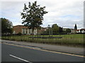
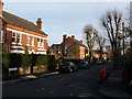
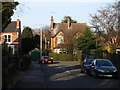
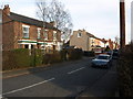
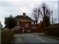
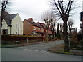
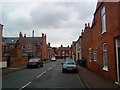
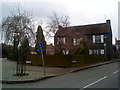
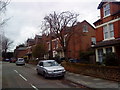
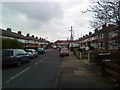
Photos of NG9 1HS


Area Information
Living in NG9 1HS offers a specific type of residential experience within a tightly defined cluster. This postcode covers a very small residential area spanning just 2,262 square metres, yet it supports a population of 1,641 people. The density here is striking, with 725,393 people per square kilometre, indicating a space-efficient community layout. Residents find themselves in a compact environment where homes are closely situated. This concentration shapes the daily rhythm of life, creating an atmosphere where neighbours are often close by definition. The location serves as a pragmatic base for accessing wider Nottinghamshire services while maintaining a contained footprint. You trade expansive grounds for proximity and immediate access to local transport links. The area functions as a distinct node within the broader housing market, offering a focused living arrangement that suits those who prioritise convenience over space. Understanding the scale of this 2,262 m² enclosure is vital when visualising property pricing and potential value retention in this specific NG9 1HS sector.
- Area Type
- Postcode
- Area Size
- 2262 m²
- Population
- 1641
- Population Density
- 5861 people/km²
The property market in NG9 1HS is characterised by a predominantly house-based stock. All listed accommodation types for this postcode are categorised simply as houses. This distinction is significant for buyers seeking traditional ground-floor living or larger family spaces, as flats or terrace houses do not appear in the primary housing classification for this specific NG9 1HS cluster. Home ownership levels sit at forty per cent, which suggests a balanced mix of bought properties and rentals, though the owner-occupied sector is substantial. This forty per cent figure indicates that roughly four in ten homes are held by their current residents. For prospective buyers, this means you are competing mainly against other homeowners rather than institutional landlords. The small area size of 2,262 square metres limits the total number of available listings, meaning competition can be intense for any new entry into the market. Understanding this limited supply is crucial when valuing homes in this specific NG9 1HS postcode, as scarcity drives value.
House Prices in NG9 1HS
Showing 4 properties
| Address | Type | Beds | Baths | Last Sale Price | Last Sale Date | |
|---|---|---|---|---|---|---|
| 4 Manor Avenue, Beeston, NG9 1HS | Detached | 3 | 1 | £247,000 | Sep 2017 | |
| 2 Manor Avenue, Beeston, NG9 1HS | Detached | - | - | £62,500 | Apr 1995 | |
| 5 Manor Avenue, Beeston, NG9 1HS | Bungalow | 3 | 2 | - | - | |
| 6 Manor Avenue, Beeston, NG9 1HS | Detached | 4 | 2 | - | - |
Energy Efficiency in NG9 1HS
Residents of NG9 1HS benefit from immediate access to diverse transport and retail hubs. Five metro connections serve the area, including the Beeston Centre Tram Stop and major bus and tram interchanges. These links facilitate easy travel into Nottingham and surrounding towns. Retail options are equally prominent, with five major outlets nearby. You can shop at Tesco Nottingham, Co-op Queens, and Co-op Beeston for your daily necessities. Rail access is extensive, with five stations within easy reach. Beeston Railway Station, Attenborough Railway Station, and Nottingham Railway Station provide direct commuter options into the city centre and beyond. Nottingham Airport is also listed as a nearby amenity, offering flight possibilities for holiday travel. This five-star presence of retail and transport infrastructure ensures that living in NG9 1HS does not require long commutes for basic services. The combination of tram stops, railway stations, and supermarkets creates a self-sufficient lifestyle where most errands can be completed without a private vehicle.
Amenities
Schools
| Rank | School | Type | Entry gender | Ages |
|---|
Explore more schools in this area
Go to Schools tabDemographics
The community in NG9 1HS presents a mature demographic profile centred on adults aged between thirty and sixty-four years. This age group forms the most common household type within the cluster. The median age sits at forty-seven, suggesting a neighbourhood where families have settled or professionals have established long-term roots. Home ownership stands at forty per cent, meaning nearly two-fifths of residents possess their homes outright rather than renting. This indicator points towards a stable, owner-occupied demographic rather than a transient rental market. The predominant ethnicity is White, reflecting the broader ethnic composition of the region without specific minority data highlighted in current records. Accommodation types are exclusively listed as houses, distinguishing this postcode from urban flat-filled zones. You are looking at a community defined by stable tenure and a house-based lifestyle. Deprivation indices are not provided in the current dataset, so any assumptions about economic hardship remain speculative. The focus remains on the clear fact that forty per cent of dwellings are owner-occupied.
Household Size
Accommodation Type
Tenure
Ethnic Group
Religion
Household Composition
Age
Household Deprivation
NS-SEC
Explore more demographic insights in this area
Go to Demographics tabPlanning
Planning Constraints
- Flood RiskPremium
- Ramsar Wetland SitesPremium
- Area of Outstanding Natural BeautyPremium
- Protected Nature ReservePremium
- Protected WoodlandPremium