Area Overview for NG5 1FH
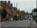
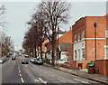
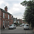
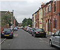
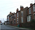
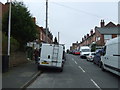
Photos of NG5 1FH


Area Information
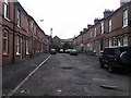
Living in NG5 1FH means residing within a compact residential cluster comprising 8,181 square metres. The neighbourhood hosts a population of 2,063 people, creating a setting where community members live in close proximity. This postcode area is situated in England and functions as a specific pocket of housing rather than a vast district. Daily life here is defined by the concentration of households within this small footprint, which distinguishes it from wider suburban sprawls. You will find a tight-knit environment where the density of residents contributes to a focused local culture. The area serves as a distinct node within the broader Nottingham region, offering a settled atmosphere for those who prefer a contained living space. While the total area is minimal, the number of homes within these boundaries supports a functioning community. Your daily routine will likely involve navigating this concentrated zone efficiently, with access to surrounding infrastructure just a short distance away. The character of NG5 1FH is shaped by this specific density, making it suitable for buyers seeking a defined residential zone without the expanses of larger boroughs.
- Area Type
- Postcode
- Area Size
- 8181 m²
- Population
- 2063
- Population Density
- 5942 people/km²
The housing stock in NG5 1FH is characterised by houses, which form the primary accommodation type within this postcode cluster. A significant 74% of residents own their homes, illustrating that this is predominantly an owner-occupied market rather than a rental hub. This statistic suggests a property market driven by those seeking to settle down and build equity, with fewer transient tenants compared to areas with lower ownership rates. As a specific postcode covering a small residential cluster, the supply of homes is naturally limited to what fits within the 8,181 square metre boundary. Buyers looking at homes in NG5 1FH will encounter a landscape of detached or semi-detached properties rather than high-rises or purpose-built blocks. The high ownership percentage indicates that many households have a vested interest in maintaining the value and condition of their properties. When considering property in this area, you are entering a market where seller motivation often stems from equity buildup rather than the immediate financial pressure of a landlord selling a letting property. This structure supports long-term investment potential for those willing to navigate the competitive nature of a home-owning neighbourhood.
House Prices in NG5 1FH
Showing 1 properties
| Address | Type | Beds | Baths | Last Sale Price | Last Sale Date | |
|---|---|---|---|---|---|---|
| Severn Trent Water Plc, Hucknall Road, Nottingham, NG5 1FH | Office | - | - | - | - |
Energy Efficiency in NG5 1FH
Amenities
Schools
Families considering schools near NG5 1FH will find a selection of educational institutions within reasonable proximity. One notable option is the Nottingham Free School, which operates as an academy and holds a good Ofsted rating. This classification indicates a standard of education that meets or exceeds national expectations. There is also the Include provision, listed as another school in the immediate vicinity, offering alternative educational pathways. The presence of an academy like the Nottingham Free School provides a modern educational environment with specific curricula focused on student outcomes. For parents navigating schools near this postcode, the inclusion of a rated academy is a significant positive factor. The mix of school types allows families to choose between different pedagogical approaches, though the language of the data confirms available names and ratings without detailing specific catchment zones. You can rely on the recorded Ofsted status when assessing future schooling options for your children in this neighbourhood.
| Rank | School | Type | Entry gender | Ages |
|---|
Explore more schools in this area
Go to Schools tabDemographics
The community in NG5 1FH features a mature demographic profile with a median age of 47 years. The most common age range covers adults aged between 30 and 64 years, indicating a population dominated by established households rather than recent migrants or young teenagers. House ownership stands at an impressive 74%, suggesting that the majority of residents have purchased their homes rather than renting. This high rate of ownership points to a stable neighbourhood where families and individuals have long-term ties to their addresses. The predominant ethnic group is White, which reflects the demographic makeup of this specific cluster. Approximately three-quarters of dwellings in the area consist of houses, distinguishing it from high-density blocks or flats common in city centres. You will find a community where residents have likely invested significantly in their property, resulting in a demographic that values stability and permanence. The age structure implies that services and facilities catering to working adults and older family members are particularly relevant here.
Household Size
Accommodation Type
Tenure
Ethnic Group
Religion
Household Composition
Age
Household Deprivation
NS-SEC
Explore more demographic insights in this area
Go to Demographics tabPlanning
Planning Constraints
- Flood RiskPremium
- Ramsar Wetland SitesPremium
- Area of Outstanding Natural BeautyPremium
- Protected Nature ReservePremium
- Protected WoodlandPremium