Area Overview for NG2 2GH
Photos of NG2 2GH
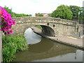
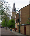

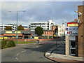
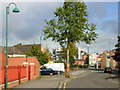
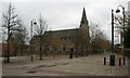
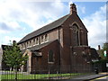
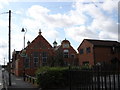
100 photos from this area
Area Information
Key information about the NG2 2GH including its size, population, and administrative classification.
- Area Type
- Postcode
- Area Size
- 2374 m²
- Population
- 1680
- Population Density
- 2428 people/km²
House Prices in NG2 2GH
13
Properties
£87,082
Average Sold Price
£35,000
Lowest Price
£135,000
Highest Price
Showing 13 properties
| Address | Type | Beds | Baths | Last Sale Price | Last Sale Date | |
|---|---|---|---|---|---|---|
| 12 Church Mews, Nottingham, NG2 2GH | Terraced | 2 | - | £110,000 | Apr 2021 | |
| 8 Church Mews, Nottingham, NG2 2GH | Terraced | 2 | 1 | £125,000 | Dec 2020 | |
| 10 Church Mews, Nottingham, NG2 2GH | Terraced | 2 | 1 | £98,500 | Dec 2018 | |
| 14 Church Mews, Nottingham, NG2 2GH | Terraced | 2 | 1 | £86,000 | Jun 2015 | |
| 9 Church Mews, Nottingham, NG2 2GH | Terraced | 2 | - | £85,000 | Dec 2014 | |
| 1 Church Mews, Nottingham, NG2 2GH | Terraced | 2 | 1 | £135,000 | Mar 2013 | |
| 2 Church Mews, Nottingham, NG2 2GH | Terraced | - | - | £134,950 | May 2007 | |
| 4 Church Mews, Nottingham, NG2 2GH | house | 3 | - | £69,000 | Dec 1999 | |
| 3 Church Mews, Nottingham, NG2 2GH | Terraced | - | - | £41,500 | Mar 1999 | |
| 7 Church Mews, Nottingham, NG2 2GH | house | 2 | 1 | £37,950 | Jun 1996 |
Page 1 of 2
Energy Efficiency in NG2 2GH
Amenities
Schools
| Rank | School | Type | Entry gender | Ages |
|---|
Explore more schools in this area
Go to Schools tabDemographics
Household Size
One person
most common
Accommodation Type
Houses
most common
Tenure
52
majority
Ethnic Group
White
most common
Religion
N/A
most common
Household Composition
N/A
most common
Age
47
median
Adults (30-64 years)
most common
Household Deprivation
N/A
with no deprivation
NS-SEC
38
in Lower managerial occupations
Explore more demographic insights in this area
Go to Demographics tabPlanning
Planning Constraints
- Flood RiskPremium
- Ramsar Wetland SitesPremium
- Area of Outstanding Natural BeautyPremium
- Protected Nature ReservePremium
- Protected WoodlandPremium