Area Overview for Boston
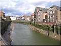
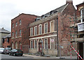
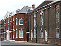
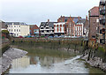
Photos of Boston


Area Information
Living in Boston means residing in a compact district borough unitary area covering just 14.5 square kilometres. You will find that over 8,700 residents call this location home, resulting in a population density of 604 people per square kilometre. This concentration creates a vivid snapshot of a locality that is neither vast wilderness nor sprawling metropolis. Instead, it offers a defined, self-contained environment where daily life moves at a manageable pace. The small geographic footprint ensures that distances between your home, local shops, and community centres remain short. You do not need a private vehicle to navigate every corner of this borough. People moving here appreciate a sense of place without the overwhelming scale of larger cities. The area functions as a tight-knit neighbourhood where the boundaries between residence and community amenities blur. This setting suits those who value proximity and defined surroundings over endless expansion. The specific mix of urban density and limited land area shapes a distinct lifestyle for everyone searching for homes in Boston.
- Area Type
- Built Up Area 250
- Area Size
- 14.5 km²
- Population
- 8729
- Population Density
- 604 people/km²
Amenities
Schools
| Rank | School | Type | Entry gender | Ages |
|---|
Explore more schools in this area
Go to Schools tabDemographics
The community in Boston reflects an older demographic profile with a median age of 70 years. This statistic indicates that the majority of the population is living through their retirement years or later life stages. Consequently, the area naturally gravitates towards quiet residential streets and established neighbourhood patterns rather than youthful commuter hubs. Data shows that 56% of households own their properties outright or through a mortgage, while nearly half of the population rents. This split suggests a balanced market where long-term residents hold a significant stake in the local housing stock. With such an age profile, you will encounter fewer young families moving in for career ladders. The household composition supports steady, established living arrangements rather than rapid turnover. These figures highlight a community built on stability and lower transient activity. For anyone researching schools near Boston, the age data illustrates a market skewed towards seniors rather than school-aged children.