Area Overview for DE22 1FT
Photos of DE22 1FT
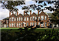
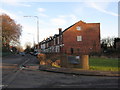
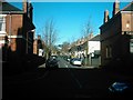
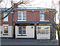
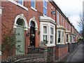
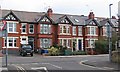
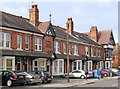
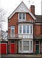
62 photos from this area
Area Information
Key information about the DE22 1FT including its size, population, and administrative classification.
- Area Type
- Postcode
- Area Size
- 2.2 hectares
- Population
- 2247
- Population Density
- 3590 people/km²
House Prices in DE22 1FT
48
Properties
£243,258
Average Sold Price
£68,000
Lowest Price
£532,000
Highest Price
Showing 48 properties
| Address | Type | Beds | Baths | Last Sale Price | Last Sale Date | |
|---|---|---|---|---|---|---|
| 177 Kedleston Road, Derby, DE22 1FT | house | - | - | £255,000 | Sep 2021 | |
| 149 Kedleston Road, Derby, DE22 1FT | house | - | - | £532,000 | Jun 2021 | |
| 161 Kedleston Road, Derby, DE22 1FT | house | - | - | £310,000 | Mar 2021 | |
| 157 Kedleston Road, Derby, DE22 1FT | house | 5 | - | £280,000 | Aug 2019 | |
| 143 Kedleston Road, Derby, DE22 1FT | Semi-detached | 5 | 2 | £330,000 | Jul 2015 | |
| 145 Kedleston Road, Derby, DE22 1FT | house | - | - | £330,000 | Oct 2013 | |
| 129 Kedleston Road, Derby, DE22 1FT | Detached | 4 | 1 | £230,000 | Jun 2008 | |
| 151 Kedleston Road, Derby, DE22 1FT | Semi-detached | 6 | - | £230,000 | Mar 2008 | |
| 163 Kedleston Road, Derby, DE22 1FT | Terraced | 4 | 2 | £221,000 | Dec 2006 | |
| 167 Kedleston Road, Derby, DE22 1FT | house | - | - | £188,067 | Jan 2005 |
Page 1 of 5
Energy Efficiency in DE22 1FT
Amenities
Schools
| Rank | School | Type | Entry gender | Ages |
|---|
Explore more schools in this area
Go to Schools tabDemographics
Household Size
One person
most common
Accommodation Type
Houses
most common
Tenure
53
majority
Ethnic Group
White
most common
Religion
N/A
most common
Household Composition
N/A
most common
Age
47
median
Adults (30-64 years)
most common
Household Deprivation
N/A
with no deprivation
NS-SEC
40
in Lower managerial occupations
Explore more demographic insights in this area
Go to Demographics tabPlanning
Planning Constraints
- Flood RiskPremium
- Ramsar Wetland SitesPremium
- Area of Outstanding Natural BeautyPremium
- Protected Nature ReservePremium
- Protected WoodlandPremium