Area Overview for DE11 7BQ
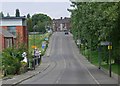
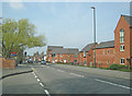
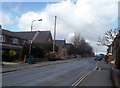
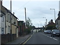
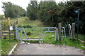
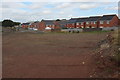
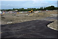
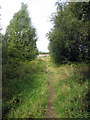
Photos of DE11 7BQ
Area Information
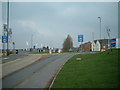
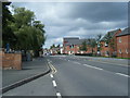
Living in DE11 7BQ, a small postcode area in the village of Woodville, means inhabiting a suburban cluster at the crossroads of South Derbyshire and North West Leicestershire. With a population of 1,692 spread over 1.8 hectares, the area is densely populated yet retains a village character. The Tollgate, a central traffic island on the A511 road, anchors daily life, surrounded by red brick settlements and farmland. Woodville’s history as a 19th-century industrial hub—once home to potteries, breweries, and railways—lives on in its landscape, now punctuated by modern housing developments. The village has grown by over 60% since 2001, driven by new homes, yet retains historic landmarks like St Stephen’s Church and Masseys DIY store. Residents enjoy a mix of modern convenience and heritage, with the A511 offering easy access to nearby towns like Swadlincote and Burton-upon-Trent. The area’s compact size means amenities are within walking distance, while its proximity to major roads and rail links ensures connectivity to larger cities.
- Area Type
- Postcode
- Area Size
- 1.8 hectares
- Population
- 1692
- Population Density
- 4899 people/km²
The property market in DE11 7BQ is characterised by high home ownership, with 79% of properties owned by residents rather than rented. This suggests a market skewed towards owner-occupied homes, likely attracting buyers seeking long-term stability rather than investors. The accommodation type is predominantly houses, which are more common than flats or apartments, reflecting a suburban, family-oriented demographic. Given the area’s small size—just 1.8 hectares—housing stock is limited, and the immediate surroundings may offer more options. Buyers should consider the proximity to amenities like retail parks and rail links, though the area’s compact nature means competition for properties could be fierce. The high home ownership rate also implies a mature market with established values, but the lack of rental properties may limit flexibility for those requiring short-term housing solutions.
House Prices in DE11 7BQ
Showing 33 properties
| Address | Type | Beds | Baths | Last Sale Price | Last Sale Date | |
|---|---|---|---|---|---|---|
| 4 Astbury Way, Woodville, Swadlincote, DE11 7BQ | house | - | - | £220,000 | Oct 2025 | |
| 19 Astbury Way, Woodville, Swadlincote, DE11 7BQ | Semi-detached | 3 | 2 | £217,500 | May 2025 | |
| 34 Astbury Way, Woodville, Swadlincote, DE11 7BQ | Detached | 4 | 2 | £295,000 | Mar 2025 | |
| 18 Astbury Way, Woodville, Swadlincote, DE11 7BQ | house | 3 | 1 | £200,000 | Sep 2024 | |
| 28 Astbury Way, Woodville, Swadlincote, DE11 7BQ | Semi-detached | 3 | 2 | £190,000 | Jun 2024 | |
| 5 Astbury Way, Woodville, Swadlincote, DE11 7BQ | Semi-detached | 3 | 2 | £205,000 | Apr 2024 | |
| 31 Astbury Way, Woodville, Swadlincote, DE11 7BQ | Detached | 4 | 2 | £248,500 | Jan 2024 | |
| 26 Astbury Way, Woodville, Swadlincote, DE11 7BQ | house | - | - | £192,500 | Dec 2021 | |
| 21 Astbury Way, Woodville, Swadlincote, DE11 7BQ | house | - | - | £189,950 | Jan 2021 | |
| 15 Astbury Way, Woodville, Swadlincote, DE11 7BQ | house | - | - | £175,000 | Dec 2020 |
Energy Efficiency in DE11 7BQ
Daily life in DE11 7BQ is shaped by its proximity to retail, education, and community hubs. The area’s nearby amenities include supermarkets like Tesco Woodville, Asda Woodville Burton, and Aldi Castle, ensuring easy access to groceries and everyday essentials. The village’s historic Tollgate roundabout hosts Masseys DIY store, a long-standing local business, while the A511 road connects to schools, including an infant school and Church of England Junior School. Woodville Rangers Football Club, nicknamed “The Tollers,” offers recreational activity for all ages. Though the area lacks large parks, its mix of farmland, hedgerows, and recent tree planting from the National Forest provides green space. The compact layout means residents can walk to shops, schools, and community events, fostering a close-knit feel. However, the absence of detailed information on dining or leisure venues beyond the listed retail options suggests a focus on practicality over luxury.
Amenities
Schools
| Rank | School | Type | Entry gender | Ages |
|---|
Explore more schools in this area
Go to Schools tabDemographics
The community in DE11 7BQ is predominantly middle-aged, with a median age of 47 and the most common age range being adults aged 30–64. This suggests a stable population of families and professionals, with 79% of homes owned outright, indicating long-term residency. The accommodation type is primarily houses, reflecting a residential area focused on family living rather than flats or apartments. The predominant ethnic group is White, though no specific diversity statistics are provided. The high home ownership rate and age profile suggest a community prioritising stability and long-term investment. However, the area’s small size and density—91,894 people per square kilometre—mean it is compact and possibly lacking in green spaces compared to larger towns. This density, combined with a mature population, may influence local services and amenities, though the area’s proximity to retail and transport links helps offset any limitations.
Household Size
Accommodation Type
Tenure
Ethnic Group
Religion
Household Composition
Age
Household Deprivation
NS-SEC
Explore more demographic insights in this area
Go to Demographics tabPlanning
Planning Constraints
- Flood RiskPremium
- Ramsar Wetland SitesPremium
- Area of Outstanding Natural BeautyPremium
- Protected Nature ReservePremium
- Protected WoodlandPremium