Area Overview for DE1 3PP
Photos of DE1 3PP
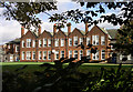
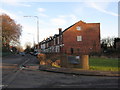
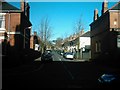
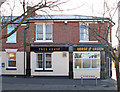
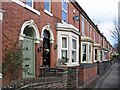
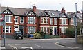
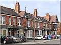
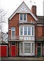
62 photos from this area
Area Information
Key information about the DE1 3PP including its size, population, and administrative classification.
- Area Type
- Postcode
- Area Size
- 3607 m²
- Population
- 1942
- Population Density
- 5467 people/km²
House Prices in DE1 3PP
27
Properties
£118,042
Average Sold Price
£43,750
Lowest Price
£192,000
Highest Price
Showing 27 properties
| Address | Type | Beds | Baths | Last Sale Price | Last Sale Date | |
|---|---|---|---|---|---|---|
| 34 Leyland Street, Derby, DE1 3PP | Terraced | 3 | 1 | £156,000 | Mar 2025 | |
| 36 Leyland Street, Derby, DE1 3PP | Terraced | 2 | 1 | £162,000 | May 2023 | |
| 33 Leyland Street, Derby, DE1 3PP | Terraced | 2 | 2 | £192,000 | Jun 2022 | |
| 38 Leyland Street, Derby, DE1 3PP | Terraced | 2 | 1 | £141,000 | Mar 2022 | |
| 27 Leyland Street, Derby, DE1 3PP | Terraced | 3 | 1 | £135,000 | Oct 2021 | |
| 40 Leyland Street, Derby, DE1 3PP | Terraced | 2 | 1 | £139,000 | Aug 2021 | |
| 42 Leyland Street, Derby, DE1 3PP | Terraced | 2 | 1 | £136,000 | Nov 2018 | |
| 56 Leyland Street, Derby, DE1 3PP | Terraced | 2 | 1 | £148,000 | Apr 2018 | |
| 54 Leyland Street, Derby, DE1 3PP | Terraced | 2 | 1 | £127,500 | Apr 2018 | |
| 15 Leyland Street, Derby, DE1 3PP | Terraced | 2 | 1 | £146,000 | Mar 2016 |
Page 1 of 3
Energy Efficiency in DE1 3PP
Amenities
Schools
| Rank | School | Type | Entry gender | Ages |
|---|
Explore more schools in this area
Go to Schools tabDemographics
Household Size
One person
most common
Accommodation Type
Flats
most common
Tenure
26
majority
Ethnic Group
White
most common
Religion
N/A
most common
Household Composition
N/A
most common
Age
22
median
Young Adults (15-29 years)
most common
Household Deprivation
N/A
with no deprivation
NS-SEC
19
in Lower managerial occupations
Explore more demographic insights in this area
Go to Demographics tabPlanning
Planning Constraints
- Flood RiskPremium
- Ramsar Wetland SitesPremium
- Area of Outstanding Natural BeautyPremium
- Protected Nature ReservePremium
- Protected WoodlandPremium