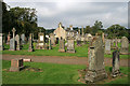
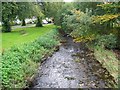
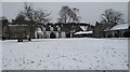
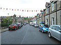
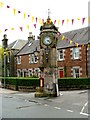
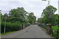
Area Overview for West Linton
Photos of West Linton


Area Information
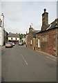
West Linton is a built-up area in Scotland, spanning 82.7 hectares. As a small town or city, it offers a compact living environment with a focus on local amenities and community connections. The area’s size suggests a tightly knit neighbourhood, where daily life is likely shaped by nearby shops, services, and local landmarks. While specific details on population are not provided, the presence of a single notable retail amenity, Co-op West, indicates a basic level of commercial infrastructure. Residents may find the area appealing for its straightforward access to essentials, though the limited data suggests it is not a sprawling urban hub. For those considering living in West Linton, the blend of practicality and proximity to key services could be a draw, especially for those prioritising convenience over larger urban offerings. The area’s character is defined by its modest scale and the availability of nearby amenities, making it a viable option for those seeking a simpler, community-focused lifestyle.
- Area Type
- Built Up Area 250
- Area Size
- 82.7 hectares
- Population
- Not available
- Population Density
- Not available
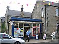
Residents of West Linton have access to a small but functional selection of amenities within practical reach. The Co-op West is the most notable retail presence, providing essential shopping and services. While no other specific venues are listed, this single retail point suggests a focus on basic needs over expansive leisure or dining options. The absence of detailed data on parks, dining, or recreational facilities means the area’s lifestyle character remains somewhat undefined. However, the presence of Co-op West implies a community-oriented approach to daily living, where convenience and accessibility are prioritised. For those valuing simplicity and proximity to essentials, West Linton may offer a straightforward, no-frills lifestyle. The lack of additional amenities, though, means that residents may need to travel further for more varied leisure or entertainment options.
Amenities
Schools
| Rank | School | Type | Entry gender | Ages |
|---|
Explore more schools in this area
Go to Schools tabDemographics
Household Size
Accommodation Type
Tenure
Ethnic Group
Religion
Household Composition
Age
Household Deprivation
NS-SEC
Explore more demographic insights in this area
Go to Demographics tabPlanning
Planning Constraints
- Crime RiskPremium