Area Overview for Dunblane
Photos of Dunblane


Area Information
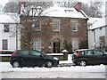
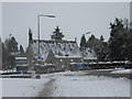
Dunblane is a compact built-up area in Scotland covering approximately 3.5 kilometres squared. This small town offers a lived-in community feel rather than the sprawling anonymity of a larger city. Residents here experience a strong sense of proximity to one another, which defines daily life in the region. The area serves as a practical base for those who seek stability and local knowledge over rapid urban expansion. Living in Dunblane means navigating a landscape where neighbours are often well-known, creating a familiar environment for families and professionals. The town functions as a distinct hub within the wider Scottish network, offering escape routes to larger cultural centres while maintaining its own character. Homes in Dunblane benefit from a straightforward layout that prevents excessive travel times for local errands. You will find that the pace of life remains steady, supported by a clear understanding of the local geography. This context helps buyers choose properties with confidence, knowing the physical boundaries of the town. The area represents a manageable territory where routes to Stirling or Perthshire are well established. A home here provides a stable foundation for long-term living without the complexity found in metropolitan zones.
- Area Type
- Built Up Area 250
- Area Size
- 3.5 km²
- Population
- Not available
- Population Density
- Not available
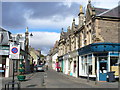
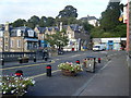
Daily life in Dunblane is supported by a cluster of amenities within practical reach of every resident. Local shopping is conveniently handled at Tesco Dunblane, offering essentials you need without a long journey. For branded fashion and general retail, M&S Dunblane SF and Co-op Stirling are accessible stops along your regular route. These stores open your mornings with supplies or close your evenings with necessities. The town spot also offers three distinct railway stations, enhancing your ability to travel beyond the built-up area. Dunblane Railway Station serves as the primary point of departure for regional trains. Bridge of Allan Railway Station and Stirling Railway Station provide alternative links for longer journeys or specific destinations. You can reach these transport hubs easily for business travel or weekend getaways. The density of these amenities means you rarely need to drive far for basic requirements. This concentration of services supports a lifestyle centred on convenience and regular access to goods. Whether you are buying groceries or planning a trip, the local infrastructure holds you well. It is a straightforward setup where quality of life depends on proximity to these key nodes.
Amenities
Schools
| Rank | School | Type | Entry gender | Ages |
|---|
Explore more schools in this area
Go to Schools tabDemographics
The population of the built-up area reveals specific groupings common to towns of its size. Data indicates that a significant portion of the 0 to 15 age group is 15.59%, suggesting a steady presence of children in schools near Dunblane. The working-age demographic between 16 and 30 makes up 20.70% of the total population, indicating a substantial cohort of young adults and recent graduates. Those aged 30 to 44 form 19.89% of the inhabitants, representing the core of the local workforce. The 45 to 59 age bracket constitutes 9.95%, while residents over 60 account for 9.18%. Gilbreath Primary School and the primary education sector likely see consistent attendance given these figures. Household structures show that 28.07% of homes consist of a lone person, which is higher than the national average. This statistic reflects significant numbers of individuals living independently or renting. One-person households often require smaller properties, influencing the demand for specific accommodation types. The presence of single-occupant homes suggests a diverse housing need. You will encounter many single-people households among the total population, alongside larger families and multi-generational setups typical of Scottish towns. These demographics shape the local economy and service requirements daily.
Household Size
Accommodation Type
Tenure
Ethnic Group
Religion
Household Composition
Age
Household Deprivation
NS-SEC
Explore more demographic insights in this area
Go to Demographics tabPlanning
Planning Constraints
- Crime RiskPremium