Area Overview for IV54 8UY
Photos of IV54 8UY


Area Information
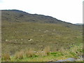
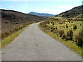
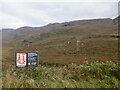
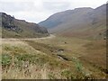
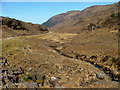
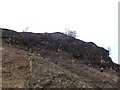
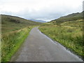
The postcode IV54 8UY occupies a specific residential cluster across an extensive landscape of 98.8 km² in Scotland. Living in this area means navigating a small residential pocket within a broad rural expanse. Daily life here is defined by significant distances rather than dense urban convenience. The sheer scale of the postcode area indicates that residents must plan carefully for commutes and local trips. You are part of a small residential cluster situated far from the immediate bustle of larger towns. This region stands apart from typical Scottish postcodes due to its vast footprint relative to the housing present. Prospective buyers should understand that IV54 8UY is not a single street but a wide territory. The environment is distinctive because it blends private dwellings with substantial natural reserves. You will find yourself in a location where space is abundant but community proximity requires effort. The area's identity is bound up with its rural character and the constraints imposed by protected lands. Understanding this geography is essential for anyone considering homes in IV54 8UY.
- Area Type
- Postcode
- Area Size
- 98.8 km²
- Population
- Not available
- Population Density
- Not available
Housing stock in IV54 8UY cannot be characterised in detail because specific data on home ownership percentages and accommodation types are not provided. You cannot determine if the area is primarily owner-occupied or driven by the rental market without these key figures. The available information only confirms that the postcode covers a small residential cluster spread across 98.8 km². Without breakdowns of flat versus single-family dwelling types, you cannot assess the variety of homes in IV54 8UY. The market composition remains opaque regarding the ratio of ownership to renting. This absence of data makes it difficult for buyers to gauge whether they compete in a purchase market or a lease market. The scale of the area suggests some variability, but confirming this requires statistics that are currently missing. You should proceed with caution assuming a standard market structure. The nature of the dwellings within this rural cluster remains unquantified by the available records.
House Prices in IV54 8UY
Showing 8 properties
Energy Efficiency in IV54 8UY
Amenities
Schools
| Rank | School | Type | Entry gender | Ages |
|---|
Explore more schools in this area
Go to Schools tabDemographics
Information regarding the specific age profile, household types, home ownership levels, and diversity of the community in IV54 8UY is not included in the available data. Consequently, any description of the local population's makeup would be purely speculative and lacks factual basis. Without specific figures on age or household composition, it is impossible to state who exactly lives here or how the population is distributed. Similarly, there is no data available to define the level of diversity within this specific postcode sector. The absence of these demographic details means you cannot determine whether the area is dominated by young professionals, families with children, or retirees. Present deprivation data or accommodation specifics for IV54 8UY is not possible under current reporting constraints. You must approach your decision based on the known physical attributes of the land rather than unknown human statistics. The lack of population statistics prevents a clear picture of the community feel.
Household Size
Accommodation Type
Tenure
Ethnic Group
Religion
Household Composition
Age
Household Deprivation
NS-SEC
Explore more demographic insights in this area
Go to Demographics tabPlanning
Planning Constraints
- Flood RiskPremium
- Ramsar Wetland SitesPremium
- Area of Outstanding Natural BeautyPremium
- Protected Nature ReservePremium
- Protected WoodlandPremium
- Crime RiskPremium