Area Overview for IV42 8WZ
Photos of IV42 8WZ


Area Information
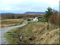
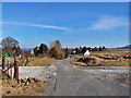
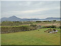
IV42 8WZ is a small residential cluster in Scotland, positioned near the coast and close to natural landscapes. The area is defined by its compact size, with homes likely spread across a limited footprint. Its location near the Broadford Ferry Terminal and Kyle of Lochalsh Railway Station suggests it is a place where transport options are practical for daily needs. The nearby Asda Broadford and Co-op Kyle of provide essential retail services, while the railway station connects residents to broader networks. This postcode is likely to appeal to those seeking a quiet, low-density living environment, with easy access to both local amenities and regional travel. The absence of major planning constraints, such as protected woodlands or AONB areas, means development is not restricted by environmental designations. However, the broadband score of 23 indicates poor internet connectivity, which could affect remote work opportunities. Despite this, the area’s proximity to natural beauty and transport links makes it a viable choice for those prioritising convenience over digital infrastructure.
- Area Type
- Postcode
- Area Size
- Not available
- Population
- Not available
- Population Density
- Not available
House Prices in IV42 8WZ
No properties found in this postcode.
Energy Efficiency in IV42 8WZ
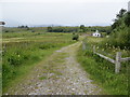
Residents of IV42 8WZ have access to essential retail options, including Asda Broadford and Co-op Kyle of, which cater to daily shopping needs. The Broadford Ferry Terminal is a key local facility, offering transport to nearby islands and coastal destinations, which enhances the area’s appeal for those who enjoy maritime activities or require ferry-based commuting. The Kyle of Lochalsh Railway Station provides rail links to larger towns, connecting the community to broader services and employment opportunities. While the area lacks extensive leisure or dining options, its proximity to natural landscapes and transport hubs suggests a lifestyle centred on simplicity and practicality. The small scale of the postcode means amenities are closely spaced, reducing travel time for essentials. This combination of local retail, transport, and coastal access creates a self-contained environment for residents prioritising convenience over urban vibrancy.
Amenities
Schools
| Rank | School | Type | Entry gender | Ages |
|---|
Explore more schools in this area
Go to Schools tabDemographics
Household Size
Accommodation Type
Tenure
Ethnic Group
Religion
Household Composition
Age
Household Deprivation
NS-SEC
Explore more demographic insights in this area
Go to Demographics tabPlanning
Planning Constraints
- Flood RiskPremium
- Ramsar Wetland SitesPremium
- Area of Outstanding Natural BeautyPremium
- Protected Nature ReservePremium
- Protected WoodlandPremium
- Crime RiskPremium