Area Overview for IV18 0DE
Photos of IV18 0DE


Area Information
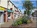
IV18 0DE is a small, tightly defined postcode area in Scotland, covering just 729 square metres. It sits within a compact residential cluster, likely centred around a mix of traditional and modern housing. The area’s proximity to Invergordon and Alness suggests a quiet, community-focused lifestyle, with easy access to nearby towns and natural features. Residents here benefit from excellent broadband connectivity, rated at 100 out of 100, ensuring seamless digital access for work, education, and entertainment. While mobile coverage is rated 75, which is good but not exceptional, it remains sufficient for most daily needs. The area’s low flood risk and absence of protected natural sites indicate a stable environment, free from planning restrictions that might complicate development or living. For those seeking a peaceful, small-scale community with practical infrastructure, IV18 0DE offers a blend of convenience and tranquility. Its proximity to rail and ferry services also hints at a strategic location for commuters or those who enjoy coastal travel. Living here means balancing local amenities with the broader opportunities of nearby towns, all within a manageable footprint.
- Area Type
- Postcode
- Area Size
- 729 m²
- Population
- Not available
- Population Density
- Not available
House Prices in IV18 0DE
Showing 1 properties
| Address | Type | Beds | Baths | Last Sale Price | Last Sale Date | |
|---|---|---|---|---|---|---|
| Royal Mail, Invergordon Delivery Office, 61 High Street, Invergordon, IV18 0DE | warehouse | - | - | - | - |
Energy Efficiency in IV18 0DE
Daily life in IV18 0DE is shaped by its proximity to essential amenities. Retail options include Farmfoods Invergordon, Co-op Invergordon, and Lidl Alness, providing grocery and convenience shopping within easy reach. The area’s rail and ferry connections also open doors to broader leisure opportunities, from coastal walks to cultural events in nearby towns. While the data doesn’t specify parks or recreational spaces, the absence of protected natural sites suggests a focus on local, community-based leisure rather than large-scale green spaces. The practical reach of amenities means residents can access shopping, transport, and travel options without lengthy commutes. This balance of local convenience and regional connectivity makes IV18 0DE suitable for those who value accessibility without sacrificing the quiet, small-area atmosphere.
Amenities
Schools
| Rank | School | Type | Entry gender | Ages |
|---|
Explore more schools in this area
Go to Schools tabDemographics
Household Size
Accommodation Type
Tenure
Ethnic Group
Religion
Household Composition
Age
Household Deprivation
NS-SEC
Explore more demographic insights in this area
Go to Demographics tabPlanning
Planning Constraints
- Flood RiskPremium
- Ramsar Wetland SitesPremium
- Area of Outstanding Natural BeautyPremium
- Protected Nature ReservePremium
- Protected WoodlandPremium
- Crime RiskPremium