Area Overview for Neilston
Photos of Neilston


Area Information
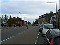
Neilston stands as a built-up area within West Scotland, covering a compact footprint of just 1.3 square kilometres. You will find this district is part of a larger, dense urban settlement rather than a dispersed village. Its small size defines the local experience, creating a neighbourhood that feels tight-knit yet connected to the wider Glasgow region. Residents here manage their daily commutes and local errands within a framework designed for efficiency. The area functions as a residential pocket that relies on proximity for its character. Living in Neilston means engaging with a community where space is defined by density and historical development patterns. The location offers a practical base for those seeking housing in Scotland without needing to travel far for major urban centres. Your daily life revolves around the efficiency of this built environment, where everything from transport links to essential services is clustered within a manageable radius. This area suits those who prefer a distinct locality near major cities rather than isolated rural settings. The compact nature ensures that you can access a range of infrastructure without requiring extensive planning or long drives for routine needs.
- Area Type
- Built Up Area 250
- Area Size
- 1.3 km²
- Population
- Not available
- Population Density
- Not available
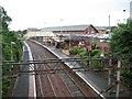
Your daily routine in Neilston benefits from quick access to essential services and travel hubs. You can shop at Co-op Neilston for local groceries, while larger retail options like Tesco Glasgow are within practical reach. Residents also have outlets for discounted goods at Farmfoods Barrhead. Getting started your day or commuting is facilitated by a network of five railway stations nearby. Neilston Railway Station serves your immediate needs, while Barrhead Railway Station and Nitshill Railway Station offer further regional connections. Glasgow International Airport lies nearby, providing convenient access for longer journeys. These transport links mean you do not need to rely solely on personal vehicles for regular travel. The area offers solid convenience for shopping and transit without requiring a lengthy wardrobe change or a significant drive.
Amenities
Schools
| Rank | School | Type | Entry gender | Ages |
|---|
Explore more schools in this area
Go to Schools tabDemographics
You cannot find specific statistics regarding age profiles, household types, or the mix of owner-occupiers and tenants in the current information for Neilston. The available figures do not extend to these traditional demographic markers. Without a breakdown of home ownership levels or accommodation categories, it remains unclear what proportion of residents rent versus buy. Diversity metrics and deprivation indices are similarly absent from the provided records. Consequently, you cannot determine the typical family size or employment structure within the community. The lack of detailed census data for these specific categories limits a deep analysis of the population composition. You are left without insight into whether the area attracts young professionals, families, or retirees. Existing records simply do not contain the detailed breakdowns required to describe the social fabric in terms of numbers. This absence means any claim about the specific age distribution or mix of home ownership types would be unsupported by the available source material. The community profile remains undefined in the current dataset.
Household Size
Accommodation Type
Tenure
Ethnic Group
Religion
Household Composition
Age
Household Deprivation
NS-SEC
Explore more demographic insights in this area
Go to Demographics tabPlanning
Planning Constraints
- Crime RiskPremium