Area Overview for PH2 7NU
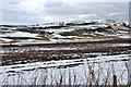
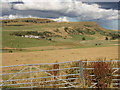
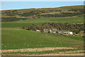
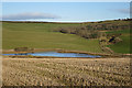
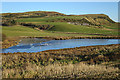
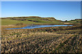
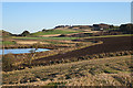
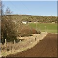
Photos of PH2 7NU

Area Information
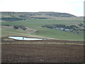
Living in PH2 7NU offers a grounded experience defined by its status as a small residential cluster within the Perth and Kinross council area. This postcode covers just 2.5 km², creating an intimate living environment where residents know their immediate surroundings by name. As part of the historic county of Perthshire, the location draws on a legacy stretching back to 1930 when the counties of Perthshire and Kinross-shire joint councils first combined. Today, this unitary council area forms a significant administrative district in central Scotland, bordered by Highland, Aberdeenshire, Angus, Dundee, Fife, Clackmannanshire, Stirling, and Argyll and Bute. The specific location of PH2 7NU places residents at the heart of practical connectivity, sitting near the eastern boundary of the ceremonial county. You will find yourself surrounded by a quiet suburban landscape typical of the region, away from the dense urban centres of Dundee or Edinburgh. The area represents a slice of traditional Scottish life where community bonds often run deep due to the close proximity of homes and local facilities.
- Area Type
- Postcode
- Area Size
- 2.5 km²
- Population
- Not available
- Population Density
- Not available
The property market in PH2 7NU is shaped by its limited geographic footprint, covering only 2.5 km². This small footprint means the supply of homes is finite, often resulting in a market where available properties move quickly due to low inventory. There are no data points available on specific home ownership percentages or the exact mix of flats versus detached houses for this specific postcode. However, the area's classification as a residential cluster within Perth and Kinross suggests a predominance of standard suburban housing rather than commercial or industrial use. Prospective buyers should understand that this location offers a niche market where competition for the few available units can be keen. The lack of major planning constraints like protected nature reserves or areas of outstanding natural beauty removes potential hurdles from the development process, meaning existing homes remain the primary opportunity. You are likely to find a stock of family-sized properties or bungalows typical of the region, reflecting the needs of the local workforce who commute to Perth or other nearby towns. The value of these homes is influenced heavily by their proximity to ratings schools and local retail hubs rather than speculative future developments.
House Prices in PH2 7NU
Showing 9 properties
Energy Efficiency in PH2 7NU
Daily life in PH2 7NU revolves around a compact selection of amenities that cater to practical needs rather than luxury shopping. Residents have access to one nearby airport, Perth/Scone Airport, which serves regional travel requirements without adding significant distance to daily commutes. For essential high-street shopping, five retail venues are located within a convenient distance. Tesco Perth stands as the primary destination for groceries and household goods, while Co-op Scone and Spar offer smaller, more accessible options for quick errands or fresh produce. This concentration of retail ensures you can manage your weekly shop without venturing far from home. Transport links are anchored by Perth Railway Station, which connects you to the wider national rail network efficiently. The local environment provides green spaces without the regulatory burdens of protected nature reserves, allowing for free and easy recreation. You can enjoy walking trails that skirt through areas of protected woodland nearby, though you must respect the restrictions associated with these conservation zones. The area does not contain Ramsar wetland sites or designated Areas of Outstanding Natural Beauty, meaning development pressures remain low and the landscape retains its character.
Amenities
Schools
| Rank | School | Type | Entry gender | Ages |
|---|
Explore more schools in this area
Go to Schools tabDemographics
The community in PH2 7NU reflects the broader patterns of settlement found in Perth and Kinross, though specific age profiles and household breakdowns are not detailed for this exact postcode. The surrounding area is characterised by a mix of accommodation types suitable for families and professionals working in the wider region. While precise statistics on diversity or specific deprivation levels are not provided for this tiny cluster, the absence of high-profile planning constraints suggests a stable environment for residents. The population here likely mirrors the consistent nature of the wider council area, which encompasses historic towns and rural villages alike. Home ownership levels often remain steady in such established residential zones, providing security for long-term residents. Without specific data on household size or income distribution, one must look to the structural stability of the housing stock as the primary indicator of demographic health. The area does not suffer from the environmental restrictions that might displace certain types of tenure, allowing for a continuous residential presence over many years.
Household Size
Accommodation Type
Tenure
Ethnic Group
Religion
Household Composition
Age
Household Deprivation
NS-SEC
Explore more demographic insights in this area
Go to Demographics tabPlanning
Planning Constraints
- Flood RiskPremium
- Ramsar Wetland SitesPremium
- Area of Outstanding Natural BeautyPremium
- Protected Nature ReservePremium
- Protected WoodlandPremium
- Crime RiskPremium