Area Overview for PH18 5TT
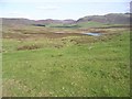
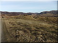
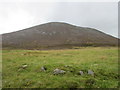
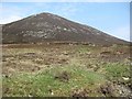
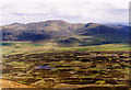
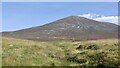
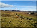
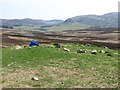
Photos of PH18 5TT


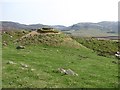
Area Information
PH18 5TT covers a specific residential cluster within the wider Perth and Kinross council area. This postcode acts as a small residential hub spread across 13.8 km² of land. Although the area sits in central Scotland, its name reflects the historic merging of two distinct localities. The history of this region dates back when the county councils combined as the Perth and Kinross Joint County Council in 1930. It later reformed as a district within the Tayside region in 1975 before becoming a unitary council area in 1996. Residents here inhabit a landscape defined by these administrative shifts. The area is bordered by counties including Angus to the east and Clackmannanshire to the south. Living in PH18 5TT means you are situated within this evolving geographical framework. The small size of this specific cluster suggests a close-knit environment rather than a sprawling suburb.
- Area Type
- Postcode
- Area Size
- 13.8 km²
- Population
- Not available
- Population Density
- Not available
Homes in PH18 5TT sit within a housing stock defined by the 13.8 km² area covering this specific postcode. The residential cluster attracts buyers seeking property within the Perth and Kinross unitary council area. You will encounter a mix of stock types suitable for the local demographic profile. The market here reflects the balance between owner-occupied homes and rental properties found across the wider region. Because the area is a small residential cluster, the number of available homes remains limited compared to larger urban centres. This scarcity can influence property prices and competition among potential buyers. Selling a home in PH18 5TT might require patience due to the defined boundaries of the postcode. Buyers looking for flats or houses in this area should account for the specific constraints of a small cluster. The property mix supports the local community needs established since the 1930s joint council formation.
House Prices in PH18 5TT
Showing 4 properties
| Address | Type | Beds | Baths | Last Sale Price | Last Sale Date | |
|---|---|---|---|---|---|---|
| Monzie Farm, U 169 From Fenderbridge To Just Past Loch Moraig, Blair Atholl, PH18 5TT | Semi-detached | - | - | - | - | |
| Monzie Farm Bothy, U 169 From Fenderbridge To Just Past Loch Moraig, Blair Atholl, PH18 5TT | Semi-detached | - | - | - | - | |
| Tom Of Lude, U 169 From Fenderbridge To Just Past Loch Moraig, Blair Atholl, PH18 5TT | house | - | - | - | - | |
| Easter Monzie, U 169 From Fenderbridge To Just Past Loch Moraig, Blair Atholl, PH18 5TT | Detached | - | - | - | - |
Energy Efficiency in PH18 5TT
Residents of PH18 5TT enjoy access to essential amenities within practical reach of their homes in this postcode. A Spar store serves the retail needs of the community, offering groceries and daily essentials. You do not need to travel far to find the basic conveniences required for daily life. The Blair Atholl Railway Station provides a vital link to the wider region for commuters and travellers. This rail connection integrates the residential cluster into the broader transport network of Perth and Kinross. While the immediate vicinity offers limited commercial options, the area connects to the larger historic counties of Perthshire and Kinross-shire. The lifestyle here is characterised by proximity to these key services. You live in a setting where a single Spar and one railway station support the entire population of this 13.8 km² zone.
Amenities
Schools
| Rank | School | Type | Entry gender | Ages |
|---|
Explore more schools in this area
Go to Schools tabDemographics
You will find the demographic profile of PH18 5TT reflected in the characteristics of the broader Perth and Kinross region. The area spans 13.8 km² and serves as a residential node for locals working across central Scotland. Community research indicates that the region combines the heritage of Perthshire and Kinross-shire. Households here navigate a landscape where specific demographic figures define daily life. The population structure aligns with trends seen in the historic counties that formed the modern unitary council. You can expect a mix of family homes and apartments within the 13.8 km² footprint. Housing stock types vary, but the small cluster size limits rapid demographic spikes. The community likely mirrors the stability found in Perth and Kinross since its reform in 1996. Residents benefit from being part of a region that includes Longforgan, which joined the area in 1996.
Household Size
Accommodation Type
Tenure
Ethnic Group
Religion
Household Composition
Age
Household Deprivation
NS-SEC
Explore more demographic insights in this area
Go to Demographics tabPlanning
Planning Constraints
- Flood RiskPremium
- Ramsar Wetland SitesPremium
- Area of Outstanding Natural BeautyPremium
- Protected Nature ReservePremium
- Protected WoodlandPremium
- Crime RiskPremium