Area Overview for PH15 2NJ
Photos of PH15 2NJ
Area Information
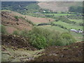
PH15 2NJ represents a specific postcode area covering a small residential cluster on 55.5 hectares within the wider Perth and Kinross council region. This location sits in central Scotland, an expanse that once comprised the historic counties of Perthshire and Kinross-shire before forming a unitary authority in 1996. Living in PH15 2NJ means being situated in a designated environment with specific planning constraints, including an Area of Outstanding Natural Beauty and protected nature reserves. These designations shape the built environment, prioritising conservation over high-density development. The area broadcasts a score of 81 for mobile coverage, indicating that most residents maintain reliable connection despite the rural nature of the setting. Fixed broadband reaches a score of 50, suggesting a moderate level of service compared to major urban centres. You can expect a quiet existence where the natural landscape takes precedence, yet you still access essential connectivity needs. This postcode is distinct because it balances the tranquility of a protected zone with the practical requirements of modern life in Tayside.
- Area Type
- Postcode
- Area Size
- 55.5 hectares
- Population
- Not available
- Population Density
- Not available
The property market within the PH15 2NJ postcode is characterised by a small residential cluster encompassing 55.5 hectares. This limited physical size restricts the total volume of available homes in the immediate vicinity. The area contains protected nature reserves and areas of outstanding natural beauty, which influences the type and location of housing stock. There is no data provided regarding the percentage of owner-occupied versus rental properties for this specific postcode. Similarly, specific accommodation types such as detached, semi-detached, or terraced housing are not quantified in the available information. Buyers must understand that purchasing a home here involves navigating planning constraints that include protected woodland and Ramsar wetland sites, the latter of which shows a pass score of zero. The absence of detailed market statistics means prospective buyers cannot assess recent price trends or average property age without further research. The presence of flood warnings with a score of 25.45 indicates that some properties may face potential water-related issues during heavy rainfall. These environmental factors should remain central to any property valuation strategy for this location.
House Prices in PH15 2NJ
Showing 7 properties
Energy Efficiency in PH15 2NJ
Amenities
Schools
| Rank | School | Type | Entry gender | Ages |
|---|
Explore more schools in this area
Go to Schools tabDemographics
Data regarding the specific age profile, household types, and diversity for PH15 2NJ is not included in the current property assessments. Consequently, any detailed description of the community's composition remains general for this small cluster. Without specific figures on population density or deprivation indices, we cannot define the exact character of the households residing on these 55.5 hectares. The absence of granular demographic data prevents a precise analysis of who lives here or what their daily routines entail. Homeowners in broader Perth and Kinross often value stability, but without local statistics for this postcode, we cannot confirm similar trends for PH15 2NJ. Planning constraints such as the presence of protected woodland and an Area of Outstanding Natural Beauty suggest that development pressure is low. This likely results in a stable population with long-term housing tenure rather than transient rental markets. While we lack numbers on income or age distribution, the safety assessment shows a medium flood risk rating of 25.45 out of 100. This specific statistic provides the most concrete insight into the living conditions for residents in this area today.
Household Size
Accommodation Type
Tenure
Ethnic Group
Religion
Household Composition
Age
Household Deprivation
NS-SEC
Explore more demographic insights in this area
Go to Demographics tabPlanning
Planning Constraints
- Flood RiskPremium
- Ramsar Wetland SitesPremium
- Area of Outstanding Natural BeautyPremium
- Protected Nature ReservePremium
- Protected WoodlandPremium
- Crime RiskPremium