Area Overview for Invergowrie
Photos of Invergowrie


Area Information
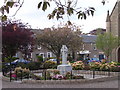
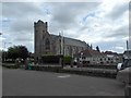
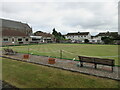
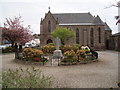
Invergowrie is a built-up area situated in Perthshire, Scotland, functioning as a distinct village near the Firth of Tay. Administratively part of Perth and Kinross, it historically belonged to Dundee City before that incorporation was reversed. The settlement currently covers 89.1 hectares and sits just inland from what was formerly the coastline, due to significant land reclamation from the Firth of Tay. You step into a landscape that blends rural tranquillity with suburban convenience. The architecture and layout reflect a history shaped by industrial work, particularly quarrying and paper manufacturing. A large freshwater lake now occupies the site of the former quarry, a feature visible from the railway line. This historical transition from industrial centre to lakeside village defines the character of homes in Invergowrie. The area offers a quiet setting away from the immediate urban sprawl of Dundee, yet remains within easy reach of the city centre. Local life revolves around this unique geography, where the legacy of the Mylne estate and early Christian church foundations meets modern residential living. Whether you are drawn to the historical cross-slab displayed in Edinburgh or the waterside views, the area provides a distinct environment for those seeking a balance of heritage and accessibility. Living in Invergowrie means enjoying a community with deep roots in stone craft and religious history, now settled into a comfortable, established village setting.
- Area Type
- Built Up Area 250
- Area Size
- 89.1 hectares
- Population
- Not available
- Population Density
- Not available
Daily life in Invergowrie centres around a blend of local convenience and proximity to larger amenities. Within practical reach, you will find five retail outlets, including Co-op Scotmid, M&S Bullionfield BP, and Morrisons Daily, catering to your weekly shopping needs. These shops are located close by, reducing the need for long journeys into Dundee for basic necessities. Two rail stations, Invergowrie Railway Station and Dundee Railway Station, are nearby, facilitating easy commutes and leisure trips. For air travel, Dundee Airport and Dundee City Airport offer convenient connections, situated just a short distance away. The area's character is deeply rooted in heritage, with the old parish church, Dargie Church or St Peter's Church, standing as a roofless 16th-century ruin on a mound by the Gowrie Burn. This historical site adds to the local atmosphere, offering a connection to early Christian history. The famous 9th-century cross-slab, carved with interlace patterns, is now housed in the Museum of Scotland in Edinburgh, a testament to the area's artistic significance. Nature plays a central role in lifestyle choices, with the flooded quarry forming a large lake visible from the station. Whether you prefer a quick trip to the shops at M&S or a day trip to Perth, the amenities are well-positioned for a comfortable life.
Amenities
Schools
| Rank | School | Type | Entry gender | Ages |
|---|
Explore more schools in this area
Go to Schools tabDemographics
The community within Invergowrie reflects the settled nature of a village that transitioned from industrial employment to a residential area. While the specific age profile, household types, ownership rates, and diversity statistics are not provided in the available data, the historical context suggests a population with ties to the land and local industries. The area was historically dependent on the paper mill until 1967 and the quarrying trade which supplied Nelson's Column and St Katherine's Docks. This industrial past has left a mark on the social fabric, creating a community that likely values stability and local connections. The significant land reclamation projects moving the village further inland indicate long-term investment in the area's infrastructure. Without current census figures on deprivation or specific demographic breakdowns, it is clear that Invergowrie serves as a home to people seeking the character of Perthshire while maintaining proximity to Dundee. The absence of severe deprivation indicators in the general description suggests a stable environment. Families and individuals drawn to the lakeside setting and historical charm likely form the backbone of the population. The village remains a cohesive unit where the legacy of the Canons regular and the Mylne family burial vaults continues to influence the sense of place. Understanding who lives here requires looking at its economic history rather than just raw numbers, as the shift from quarry and mill to homebuyers defines the current demographic landscape.
Household Size
Accommodation Type
Tenure
Ethnic Group
Religion
Household Composition
Age
Household Deprivation
NS-SEC
Explore more demographic insights in this area
Go to Demographics tabPlanning
Planning Constraints
- Crime & SafetyPremium