Area Overview for Kingussie
Photos of Kingussie


Area Information
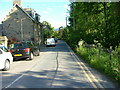
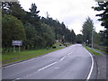
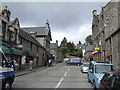
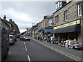
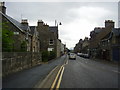
Kingussie functions as a built-up area within the wider Highlands, occupying a specific 99.3 hectares of land. It stands as one of two principal settlements in the district, situated between Wick and Aviemore. This location defines the daily experience for residents, who enjoy a town centre environment while remaining close to the outdoors. Living in Kingussie means accessing a hub for the busy Cairngorms National Park, offering a practical balance between settlement life and rural access. You will find that homes in Kingussie are typically within easy reach of the Co-op Kingussie and the nearby Newtonmore Railway Station. The area provides a solid foundation for those seeking a Scottish town experience without the isolation often associated with the Highland region. The layout supports a traditional shopping and railway hub, making essential services accessible without the need to travel long distances to major cities. This connectivity is a defining feature of life here, allowing you to manage daily tasks efficiently. The setting remains distinctly Scottish, characterised by its proximity to major transport links and recreational spaces. As a key settlement, it attracts individuals looking for a stable community location in the Highlands. You can expect a residential environment that accommodates both local families and those looking to relocate to the region for lifestyle reasons. The area represents a functional part of the wider Highland infrastructure, supporting the needs of the local population effectively.
- Area Type
- Built Up Area 250
- Area Size
- 99.3 hectares
- Population
- Not available
- Population Density
- Not available
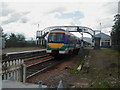
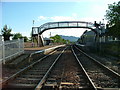
Daily life in Kingussie is supported by a compact range of amenities located within easy reach. Two Co-op stores serve the local retail needs, with Co-op Kingussie and Co-op Newtonmore offering groceries and essentials. Having two branches indicates a pleasing level of convenience, allowing you to choose between locations or visit either when shopping for household items. These retail outlets act as the primary high street, supporting the local economy and providing necessary daily services without frequent long drives. Beyond shopping, transport connectivity enhances your lifestyle by bringing wider cultural and professional opportunities closer. The two railway stations, Kingussie Railway Station and Newtonmore Railway Station, serve as social hubs where you might meet other residents or catch up on news while traveling. The area's 99.3-hectare footprint ensures you can walk or drive short distances to these key points of interest. Living in Kingussie means relying on these nearby facilities for your routine needs, creating a self-contained yet connected experience. You do not need to travel extensively to find basic provisions, which supports a relaxed pace of life. The combination of local retail and excellent rail links means you can balance town life with the wider Highlands effortlessly.
Amenities
Schools
| Rank | School | Type | Entry gender | Ages |
|---|
Explore more schools in this area
Go to Schools tabDemographics
The community profile in Kingussie reflects the typical characteristics of a Highland settlement, though specific figures on household types, age demographics, or diversity are currently unavailable in the dataset. Without these precise statistics, it is difficult to construct a detailed picture of the age distribution or the ratio of families to other household compositions for this specific area. Home ownership levels and the specific breakdown of tenancy rates are not included in the available information for Kingussie. This lack of granular demographic data prevents a full analysis of the social fabric, such as the prevalence of first-time buyers versus established residents. Deprivation metrics, which usually provide context on income and education, are also absent from the provided records for this location. Consequently, we cannot quantify the level of disadvantage or advantage that residents might face compared to national averages. The absence of these numbers means we must rely on general observations rather than statistical evidence regarding the socio-economic landscape. It remains unclear exactly what proportion of the population commutes to larger cities versus working locally within the community. While the area supports a mixed population, the specific mix of professionals, students, and retired residents cannot be detailed without the missing statistics. Future studies may clarify these aspects, but current data does not support such specific claims about who lives in Kingussie.
Household Size
Accommodation Type
Tenure
Ethnic Group
Religion
Household Composition
Age
Household Deprivation
NS-SEC
Explore more demographic insights in this area
Go to Demographics tabPlanning
Planning Constraints
- Crime RiskPremium