Area Overview for G5 8EG
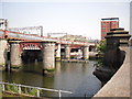
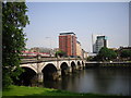
Photos of G5 8EG


Area Information
G5 8EG is a small, compact postcode area in Scotland, covering just 2.1 hectares. This residential cluster is strategically located near key transport hubs and amenities, making it a practical choice for those prioritising connectivity. The area is served by multiple ferry terminals, including Broomielaw Quay and Glasgow SECC Ferry Landing, offering easy access to water-based travel. Its proximity to Glasgow’s central rail and metro stations, such as West Street Underground and Anderston Railway Station, ensures seamless commuting. Daily life here is shaped by its urban setting, with retail options like Tesco Argyle and Co-op Glasgow within reach. While the area is small, it benefits from low flood risk and no proximity to protected natural sites, ensuring a stable living environment. Residents here are likely to be commuters or professionals seeking convenience without sacrificing safety. The compact size means the community feels close-knit, with amenities and transport networks within walking or short transit distance. For those valuing practicality and accessibility, G5 8EG offers a blend of urban infrastructure and manageable living space.
- Area Type
- Postcode
- Area Size
- 2.1 hectares
- Population
- Not available
- Population Density
- Not available
House Prices in G5 8EG
Showing 44 properties
| Address | Type | Beds | Baths | Last Sale Price | Last Sale Date | |
|---|---|---|---|---|---|---|
| Flat 7, 7 Riverview Gardens, Glasgow, G5 8EG | Flat | 2 | 2 | - | - | |
| Flat 4, 7 Riverview Gardens, Glasgow, G5 8EG | Flat | 1 | - | - | - | |
| Flat 1, 1 Riverview Gardens, Glasgow, G5 8EG | Flat | 3 | - | - | - | |
| Flat 7, 1 Riverview Gardens, Glasgow, G5 8EG | Flat | - | - | - | - | |
| Flat 8, 5 Riverview Gardens, Glasgow, G5 8EG | Flat | - | - | - | - | |
| Flat 7, 5 Riverview Gardens, Glasgow, G5 8EG | Flat | - | - | - | - | |
| Flat 2, 7 Riverview Gardens, Glasgow, G5 8EG | Flat | 1 | - | - | - | |
| Flat 7, 9 Riverview Gardens, Glasgow, G5 8EG | Flat | 1 | - | - | - | |
| Flat 3, 5 Riverview Gardens, Glasgow, G5 8EG | Flat | - | - | - | - | |
| Flat 8, 1 Riverview Gardens, Glasgow, G5 8EG | Flat | - | - | - | - |
Energy Efficiency in G5 8EG
Living in G5 8EG offers a mix of urban convenience and practical amenities. The area is within easy reach of retail outlets like Spar, Tesco Argyle, and Co-op Glasgow, ensuring everyday shopping needs are met without long journeys. Ferries provide access to Glasgow’s waterfront, while nearby metro and rail stations connect to the city’s broader network. Though the area is small, its proximity to key transport links means residents can access cultural hubs, employment centres, and leisure spots in Glasgow. The absence of protected natural sites or flood risks means the focus is on urban living, with no constraints on development or land use. For families or professionals, the balance of retail, transport, and connectivity makes G5 8EG a functional base for daily life. The compact nature of the area also means that community interactions are likely to be frequent, fostering a sense of local cohesion despite its urban setting.
Amenities
Schools
| Rank | School | Type | Entry gender | Ages |
|---|
Explore more schools in this area
Go to Schools tabDemographics
Household Size
Accommodation Type
Tenure
Ethnic Group
Religion
Household Composition
Age
Household Deprivation
NS-SEC
Explore more demographic insights in this area
Go to Demographics tabPlanning
Planning Constraints
- Flood RiskPremium
- Ramsar Wetland SitesPremium
- Area of Outstanding Natural BeautyPremium
- Protected Nature ReservePremium
- Protected WoodlandPremium
- Crime & SafetyPremium