Area Overview for G5 8DH
Photos of G5 8DH


Area Information
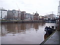
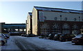
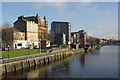
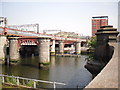
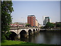
G5 8DH is a small residential postcode area in Scotland, specifically within the City of Glasgow local authority. It forms part of a compact cluster of homes, likely serving a mix of long-term residents and those seeking proximity to Glasgow’s urban infrastructure. The area benefits from its integration with Glasgow’s transport network, offering access to multiple underground stations, railway lines, and ferry terminals. While specific population figures are not provided, the postcode’s size suggests a modest community. Glasgow itself, with its Victorian architecture and historical ties to trade and shipbuilding, casts a broader cultural and economic shadow over the area. Residents here are likely to value the city’s blend of historical landmarks, modern amenities, and vibrant public spaces. The postcode’s location near the River Clyde and its connectivity to surrounding districts make it a practical choice for those prioritising accessibility over isolation.
- Area Type
- Postcode
- Area Size
- Not available
- Population
- Not available
- Population Density
- Not available
House Prices in G5 8DH
No properties found in this postcode.
Energy Efficiency in G5 8DH
Living in G5 8DH grants access to a range of essential amenities within walking or short transit distance. Retail options include Spar, Lidl Central, and Co-op Glasgow, providing everyday shopping needs. The area’s proximity to ferry terminals like Glasgow Central Station Bridge Ferry Landing and Broomielaw Quay Ferry Terminal connects residents to the River Clyde and surrounding districts. Public transport hubs such as St Enoch Underground Station and Argyle Street Railway Station offer easy access to cultural and commercial centres. While specific parks or recreational spaces are not detailed in the data, Glasgow’s broader green spaces, such as Glasgow Green, are likely within reach. The mix of retail, transport, and connectivity options suggests a lifestyle that balances practicality with urban vibrancy, catering to both daily necessities and broader exploration.
Amenities
Schools
| Rank | School | Type | Entry gender | Ages |
|---|
Explore more schools in this area
Go to Schools tabDemographics
Household Size
Accommodation Type
Tenure
Ethnic Group
Religion
Household Composition
Age
Household Deprivation
NS-SEC
Explore more demographic insights in this area
Go to Demographics tabPlanning
Planning Constraints
- Flood RiskPremium
- Ramsar Wetland SitesPremium
- Area of Outstanding Natural BeautyPremium
- Protected Nature ReservePremium
- Protected WoodlandPremium
- Crime & SafetyPremium