Area Overview for G5 0LS
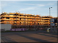
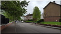
Photos of G5 0LS


Area Information
Living in G5 0LS means inhabiting a compact residential cluster in Scotland, covering 6,588 square metres. This postcode sits within a tightly knit community, offering a blend of urban convenience and residential tranquillity. The area is served by a range of transport options, including rail, metro, and ferry services, making it easy to navigate Glasgow’s broader network. Residents benefit from excellent digital connectivity, with a broadband score of 100 — the highest possible — ensuring seamless internet access for work, entertainment, and communication. However, the area carries a medium flood risk, a factor prospective buyers should consider when assessing long-term living conditions. G5 0LS is positioned near key amenities such as retail hubs, transport nodes, and cultural landmarks, though specific local attractions are not detailed in the data. The postcode’s small size means it is likely to have a close-knit community feel, with residents sharing proximity to shared services and infrastructure. For those prioritising connectivity and accessibility, G5 0LS offers a practical base within Glasgow’s dynamic urban landscape.
- Area Type
- Postcode
- Area Size
- 6588 m²
- Population
- Not available
- Population Density
- Not available
The property market in G5 0LS is likely shaped by its small footprint and proximity to transport links. While no specific home ownership percentages are provided, the presence of multiple retail and transport hubs suggests the area may attract both owner-occupiers and renters. The lack of detailed data on accommodation types means it is unclear whether the housing stock is dominated by flats, terraced homes, or other formats. However, the area’s compact size implies limited housing diversity, which could affect availability and competition for properties. Buyers should consider the area’s flood risk — a medium-level concern — when evaluating long-term investment potential. The proximity to rail, metro, and ferry services may enhance the area’s appeal for commuters, though the small postcode size means the surrounding neighbourhoods will play a significant role in determining property value trends.
House Prices in G5 0LS
Showing 9 properties
| Address | Type | Beds | Baths | Last Sale Price | Last Sale Date | |
|---|---|---|---|---|---|---|
| 11 Wolseley Terrace, Glasgow, G5 0LS | Terraced | 2 | 2 | - | - | |
| 7 Wolseley Terrace, Glasgow, G5 0LS | Terraced | 2 | 2 | - | - | |
| 1 Wolseley Terrace, Glasgow, G5 0LS | Terraced | 3 | 2 | - | - | |
| 9 Wolseley Terrace, Glasgow, G5 0LS | Terraced | 2 | 2 | - | - | |
| 3 Wolseley Terrace, Glasgow, G5 0LS | Terraced | 2 | 1 | - | - | |
| 5 Wolseley Terrace, Glasgow, G5 0LS | Terraced | 2 | - | - | - | |
| 15 Wolseley Terrace, Glasgow, G5 0LS | Terraced | - | - | - | - | |
| 17 Wolseley Terrace, Glasgow, G5 0LS | Terraced | - | - | - | - | |
| Oatlands Community Hub, 2 Wolseley Terrace, Glasgow, G5 0LS | commercial | - | - | - | - |
Energy Efficiency in G5 0LS
Residents of G5 0LS have access to a range of amenities within practical reach. The area is served by five retail outlets, including Asda Polmadie and Makro Shawfield, providing everyday shopping convenience. Transport options are extensive, with rail, metro, and ferry services connecting to key destinations such as Glasgow Central Station and Broomielaw Quay. While specific parks or leisure facilities are not detailed in the data, the proximity to Glasgow’s urban core suggests access to cultural attractions, green spaces, and community hubs. The presence of multiple transport nodes and retail options indicates a lifestyle that balances urban accessibility with residential comfort. For those prioritising connectivity and convenience, G5 0LS offers a functional base with direct links to Glasgow’s economic and cultural centres.
Amenities
Schools
| Rank | School | Type | Entry gender | Ages |
|---|
Explore more schools in this area
Go to Schools tabDemographics
The demographics of G5 0LS are not explicitly detailed in the data, but the area’s small size suggests a compact, possibly mixed household composition. No specific figures on age profiles, household types, or home ownership levels are provided, so these aspects remain unquantified. The absence of deprivation data means it is unclear how economic factors might influence quality of life here. However, the presence of multiple retail and transport hubs indicates the area may cater to a range of residents, from commuters to those seeking proximity to urban amenities. Without concrete statistics on diversity or population size, it is difficult to assess the community’s social fabric. The data does confirm that the area is served by essential infrastructure, which may support a variety of household needs. Buyers should seek additional local surveys for detailed demographic insights, as the provided information does not cover these aspects.
Household Size
Accommodation Type
Tenure
Ethnic Group
Religion
Household Composition
Age
Household Deprivation
NS-SEC
Explore more demographic insights in this area
Go to Demographics tabPlanning
Planning Constraints
- Flood RiskPremium
- Ramsar Wetland SitesPremium
- Area of Outstanding Natural BeautyPremium
- Protected Nature ReservePremium
- Protected WoodlandPremium
- Crime RiskPremium