Area Overview for G42 9AA
Photos of G42 9AA


Area Information
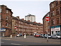
Living in G42 9AA means inhabiting a small, defined residential cluster in Scotland, where proximity to transport and amenities is a key feature. The area benefits from excellent digital connectivity, with a broadband score of 100 — the highest possible — ensuring seamless internet access for both work and leisure. Mobile coverage scores at 85 suggest reliable connectivity for on-the-go use. Nearby, residents have access to five retail outlets, including Tesco Cathcart and Sainsburys Glasgow, as well as multiple rail, metro, and ferry stations. This makes G42 9AA a convenient base for those needing regular commuting or easy access to public transport. The area’s compact size and integration with surrounding infrastructure suggest a focus on practicality, with no major natural constraints like protected woodlands or wetlands. While specific details about the community’s character are sparse, the absence of flood risk and planning restrictions indicates a stable, low-maintenance environment for residents.
- Area Type
- Postcode
- Area Size
- Not available
- Population
- Not available
- Population Density
- Not available
House Prices in G42 9AA
No properties found in this postcode.
Energy Efficiency in G42 9AA
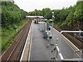
Daily life in G42 9AA is shaped by its proximity to retail, dining, and transport hubs. The area’s five retail outlets, including Tesco Cathcart and M&S Battlefield, provide convenience for shopping, while nearby rail and metro stations link to Glasgow’s vibrant commercial and cultural districts. Parks and open spaces are not explicitly mentioned in the data, but the absence of environmental constraints like protected woodlands or AONB designations suggests room for local green spaces. The presence of ferry terminals indicates access to waterfront areas, which may include recreational opportunities. For leisure, the area’s integration with Glasgow’s transport network means easy access to attractions like Kelvingrove Art Gallery, though specific local amenities remain unclear. Overall, G42 9AA offers a practical, connected lifestyle with minimal barriers to exploration or daily needs.
Amenities
Schools
| Rank | School | Type | Entry gender | Ages |
|---|
Explore more schools in this area
Go to Schools tabDemographics
Household Size
Accommodation Type
Tenure
Ethnic Group
Religion
Household Composition
Age
Household Deprivation
NS-SEC
Explore more demographic insights in this area
Go to Demographics tabPlanning
Planning Constraints
- Flood RiskPremium
- Ramsar Wetland SitesPremium
- Area of Outstanding Natural BeautyPremium
- Protected Nature ReservePremium
- Protected WoodlandPremium
- Crime & SafetyPremium