Area Overview for G3 8ST
Photos of G3 8ST


Area Information
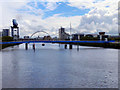
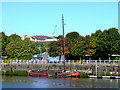
G3 8ST is a small residential postcode cluster in Glasgow, Scotland, situated within the City of Glasgow local authority. The area is part of a broader network of settlements linked by historical and modern infrastructure, reflecting Glasgow’s legacy as a hub of trade and industry. While specific population figures are not provided, the postcode’s compact nature suggests a tightly knit community with easy access to urban amenities. Glasgow’s reputation for cultural vibrancy and community spirit permeates the area, with a mix of historic architecture and contemporary living. Residents benefit from proximity to major transport routes, including rail, metro, and ferry services, which connect the area to the city’s economic and cultural centres. The surrounding environment combines urban convenience with green spaces, though detailed local features remain unquantified in the data. For those seeking a balance between city life and practical connectivity, G3 8ST offers a compact footprint with access to Glasgow’s dynamic offerings.
- Area Type
- Postcode
- Area Size
- Not available
- Population
- Not available
- Population Density
- Not available
House Prices in G3 8ST
No properties found in this postcode.
Energy Efficiency in G3 8ST
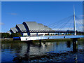
Daily life in G3 8ST is enriched by a range of nearby amenities. Retail options include major supermarkets like Tesco Old, Sainsburys Glasgow, and Morrisons Daily Glasgow, ensuring convenience for shopping needs. The area’s transport links also grant access to cultural landmarks such as the Kelvingrove Art Gallery and Glasgow Green, a historic park offering recreational space. Ferry services provide scenic routes along the Clyde, while rail and metro stations connect to events at venues like the Glasgow Science Centre. The presence of multiple transport hubs and retail centres suggests a lifestyle that balances urban energy with practicality. Though specific local parks or schools are not detailed in the data, the broader Glasgow context implies a mix of public spaces and educational institutions within reach.
Amenities
Schools
| Rank | School | Type | Entry gender | Ages |
|---|
Explore more schools in this area
Go to Schools tabDemographics
Household Size
Accommodation Type
Tenure
Ethnic Group
Religion
Household Composition
Age
Household Deprivation
NS-SEC
Explore more demographic insights in this area
Go to Demographics tabPlanning
Planning Constraints
- Flood RiskPremium
- Ramsar Wetland SitesPremium
- Area of Outstanding Natural BeautyPremium
- Protected Nature ReservePremium
- Protected WoodlandPremium
- Crime & SafetyPremium