Area Overview for G3 6NH
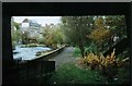
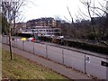
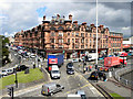
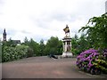
Photos of G3 6NH


Area Information
G3 6NH is a small residential postcode in Glasgow, Scotland, covering just 2.1 hectares. It sits within the City of Glasgow local authority, a historic and culturally rich area known for its Victorian and art nouveau architecture. The postcode is part of the broader G20 district, which includes communities like Forth and Clyde Canal, Lambhill, and Possil Park. Daily life here blends urban convenience with access to green spaces and cultural landmarks. Residents benefit from proximity to Glasgow Green, a major park, and the Kelvingrove Art Gallery, both within the city. The area is served by multiple transport hubs, including Kelvinbridge Underground Station and Charing Cross Railway Station, making it easy to navigate the city or travel further afield. With Glasgow International Airport just a short journey away, the area caters to both local and regional connectivity. Its compact size means a tight-knit community feel, though it remains integrated with the city’s broader amenities and historical character.
- Area Type
- Postcode
- Area Size
- 2.1 hectares
- Population
- Not available
- Population Density
- Not available
House Prices in G3 6NH
Showing 1 properties
| Address | Type | Beds | Baths | Last Sale Price | Last Sale Date | |
|---|---|---|---|---|---|---|
| St Andrews Building, 11 Eldon Street, Glasgow, G3 6NH | university_college | - | - | - | - |
Energy Efficiency in G3 6NH
Living in G3 6NH offers access to a range of amenities within walking or short transit distance. Retail options include Tesco Great and Sainsburys Glasgow, providing everyday shopping needs. The area’s proximity to Kelvinbridge Underground Station and Charing Cross Railway Station makes it easy to reach Glasgow’s bustling city centre, where dining, entertainment, and cultural attractions thrive. Nearby parks like Glasgow Green offer recreational space, while the Forth and Clyde Canal adds a scenic element to the local environment. The Kelvingrove Art Gallery, a major cultural landmark, is accessible via the city’s transport network. This blend of retail, transport, and green spaces creates a convenient, dynamic lifestyle, balancing urban energy with quieter, community-oriented amenities.
Amenities
Schools
| Rank | School | Type | Entry gender | Ages |
|---|
Explore more schools in this area
Go to Schools tabDemographics
Household Size
Accommodation Type
Tenure
Ethnic Group
Religion
Household Composition
Age
Household Deprivation
NS-SEC
Explore more demographic insights in this area
Go to Demographics tabPlanning
Planning Constraints
- Flood RiskPremium
- Ramsar Wetland SitesPremium
- Area of Outstanding Natural BeautyPremium
- Protected Nature ReservePremium
- Protected WoodlandPremium
- Crime & SafetyPremium