Area Overview for G12 9SA
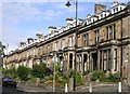
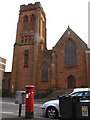
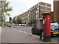
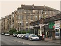
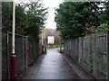
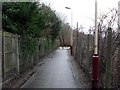
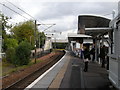
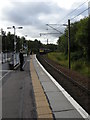
Photos of G12 9SA


Area Information
Living in G12 9SA means residing within a specific postcode cluster in Scotland that covers exactly 1654 square metres. This location represents a small, concentrated residential zone rather than a sprawling neighbourhood. You are situated in the City of Glasgow local authority, which places you firmly within the heart of a major Scottish city known for its rich cultural heritage. The broader G20 postcode district encompasses several distinct settlements, including Lambhill, Possil Park, Ruchill, and Summerston. These areas sit in the ceremonial county of Lanarkshire, offering a dynamic blend of history and modern urban living. Glasgow itself sits on the River Clyde and boasts a friendly community spirit bolstered by a dynamic mix of art and nightlife. The area benefits from excellent transport links and features impressive Victorian and art nouveau architecture. As a resident, you access culturally significant sites such as the Kelvingrove Art Gallery. The Forth and Clyde Canal runs through the wider district, providing the scenic backdrop typical of this part of the city. Daily life here is characterised by bustling markets, trendy cafes, and beautiful parks like Glasgow Green. You live in a setting where 18th-century trade history meets contemporary urban convenience. This postcode offers a grounded experience of city living without the feel of isolated rural surroundings.
- Area Type
- Postcode
- Area Size
- 1654 m²
- Population
- Not available
- Population Density
- Not available
The property market for the G12 9SA postcode area is characterised by its limited physical footprint of just 1654 square metres. This small residential cluster does not contain the vast databases of sales or listing data often found in larger subdivisions. Consequently, specific percentages regarding home ownership levels remain unavailable for this exact location. You cannot assess whether the area is dominated by owner-occupiers or rental properties using the current figures. The broader G20 postcode district includes established settlements like Ruchill and Possil Park, which typically feature a mix of housing types. As a small residential cluster, G12 9SA likely consists of a few streets or a collection of adjacent flats and terraced homes. Without detailed metrics on accommodation types, it is difficult to confirm if the area leans towards Victorian conversion or modern builds. The lack of specific home ownership data suggests a small, potentially tight-knit community where property turnover might reflect standard city market trends rather than unique local shifts. Buyers looking at the immediate surroundings in Ruchill or Summerston should expect a typical Glasgow urban market. The absence of extensive data on this specific postcode nuance means you rely on the general reputation of the wider G20 area, which is recognised for its established residential character. Pricing and availability will depend heavily on the specific property and its immediate street location within this small zone.
House Prices in G12 9SA
Showing 24 properties
| Address | Type | Beds | Baths | Last Sale Price | Last Sale Date | |
|---|---|---|---|---|---|---|
| Flat 1/1, 38 Dudley Drive, Glasgow, G12 9SA | Flat | 2 | 1 | - | - | |
| Flat 1/1, 34 Dudley Drive, Glasgow, G12 9SA | Flat | 2 | 1 | - | - | |
| Flat 3/2, 38 Dudley Drive, Glasgow, G12 9SA | Flat | 1 | 1 | - | - | |
| Flat 2/2, 38 Dudley Drive, Glasgow, G12 9SA | Flat | 1 | 1 | - | - | |
| Flat 2/2, 34 Dudley Drive, Glasgow, G12 9SA | Flat | 2 | 1 | - | - | |
| Flat 2/1, 36 Dudley Drive, Glasgow, G12 9SA | Flat | 2 | 1 | - | - | |
| Flat 0/1, 34 Dudley Drive, Glasgow, G12 9SA | Flat | - | - | - | - | |
| Flat 3/2, 36 Dudley Drive, Glasgow, G12 9SA | Flat | - | - | - | - | |
| Flat 1/2, 34 Dudley Drive, Glasgow, G12 9SA | Flat | 2 | 1 | - | - | |
| Flat 3/2, 34 Dudley Drive, Glasgow, G12 9SA | Flat | 2 | 1 | - | - |
Energy Efficiency in G12 9SA
Daily life in G12 9SA is supported by a dense array of amenities within practical reach of your doorstep. You have access to five notable retail locations, including Sainsburys Glasgow and M&S West End Glasgow SF for everyday shopping. Convenience is further enhanced by five nearby railway stations such as Jordanhill Railway Station, ensuring easy commuter access. Lifestyle relies heavily on public transport, as five metro stations like Kelvinghall Underground Station are close by. Cultural residents can utilise five ferry landings, including the Glasgow Science Centre North Quay, for quicker river access or leisure trips. Beyond utilities and transit, the area connects to the wider cultural offerings of Glasgow. You can walk to Glasgow Green, identified as a notable park within the broader city district. The Forth and Clyde Canal runs through the adjacent G20 postcode district, offering scenic routes for walking and boating. Educational provisions include Dunard Primary School, providing schooling options for families near Dunard Street in the wider district. Major cultural attractions like the Kelvingrove Art Gallery are cited as being accessible, enriching your cultural experience. This network of five retail spots, five transit hubs, and key cultural landmarks ensures that living in G12 9SA provides a balance of urban convenience and scenic leisure, anchored by the city's rich heritage.
Amenities
Schools
| Rank | School | Type | Entry gender | Ages |
|---|
Explore more schools in this area
Go to Schools tabDemographics
The specific demographic profile for the G12 9SA postcode area is not detailed in the current records. The available research focuses on the broader G20 postcode district which encompasses settlements such as Forth and Clyde Canal and Possil Park. Without granular data for this exact 1654 square metre cluster, conclusions about age profiles or household types remain speculative. You cannot determine the precise breakdown of single people versus families or the ratio of tenants to homeowners for this specific small area using the provided information. However, the context of the wider G20 postcode district suggests a complex urban environment. This area includes residential zones that have historically supported a mix of working and professional residents. The character of the city is described as dynamic, attracting a diverse population drawn to its cultural offerings. While specific statistics on income, deprivation levels, or ethnicity for G12 9SA are absent from the dataset, the location within Glasgow implies a standard urban demographic mix. Potential homebuyers should understand that detailed census data for such a small, specific postcode requires deeper local council records. The available information confirms the area is part of the City of Glasgow, but does not reveal the specific socio-economic makeup of the immediate 1654 square metres. You must rely on the general character of Glasgow and its surrounding districts to form an impression of who lives nearby.
Household Size
Accommodation Type
Tenure
Ethnic Group
Religion
Household Composition
Age
Household Deprivation
NS-SEC
Explore more demographic insights in this area
Go to Demographics tabPlanning
Planning Constraints
- Flood RiskPremium
- Ramsar Wetland SitesPremium
- Area of Outstanding Natural BeautyPremium
- Protected Nature ReservePremium
- Protected WoodlandPremium
- Crime & SafetyPremium