Area Overview for G1 4AT
Photos of G1 4AT


Area Information
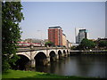
G1 4AT is a small residential postcode in Scotland, positioned within a cluster of homes that reflect Glasgow’s historical and modern character. Situated in the city of Glasgow, this area benefits from proximity to key landmarks such as the Forth and Clyde Canal and the River Clyde, which have shaped the city’s industrial and cultural identity. The postcode is part of the broader G1 district, known for its mix of Victorian architecture and contemporary urban development. Residents here enjoy a blend of local amenities, including nearby metro stations, retail outlets, and ferry terminals, which facilitate easy access to the city’s vibrant core. The area’s compact size means it is well-served by public transport, with multiple railway and underground stations within walking distance. While the population and exact area size are not specified, the postcode’s small footprint suggests a tight-knit community. Glasgow’s reputation as a city with a friendly community spirit and rich cultural heritage adds to the appeal of living in G1 4AT, where history and modernity coexist.
- Area Type
- Postcode
- Area Size
- Not available
- Population
- Not available
- Population Density
- Not available
House Prices in G1 4AT
No properties found in this postcode.
Energy Efficiency in G1 4AT
Living in G1 4AT grants access to a range of amenities within walking or short transit distance. Retail options include major supermarkets like Tesco Glasgow, Lidl Central, and Sainsburys Glasgow, ensuring everyday shopping needs are met. The area’s proximity to Glasgow Green, a historic park, offers recreational space for families and nature enthusiasts. Cultural attractions such as the Kelvingrove Art Gallery are accessible via the city’s transport links, though not directly within the postcode. The presence of multiple ferry terminals and metro stations also facilitates easy exploration of Glasgow’s markets, cafes, and nightlife. While specific dining or leisure venues are not named in the data, the area’s connectivity to the city’s core suggests a dynamic lifestyle with opportunities for both relaxation and social engagement.
Amenities
Schools
| Rank | School | Type | Entry gender | Ages |
|---|
Explore more schools in this area
Go to Schools tabDemographics
Household Size
Accommodation Type
Tenure
Ethnic Group
Religion
Household Composition
Age
Household Deprivation
NS-SEC
Explore more demographic insights in this area
Go to Demographics tabPlanning
Planning Constraints
- Flood RiskPremium
- Ramsar Wetland SitesPremium
- Area of Outstanding Natural BeautyPremium
- Protected Nature ReservePremium
- Protected WoodlandPremium
- Crime & SafetyPremium