Area Overview for Thornton (Fife)
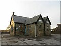
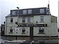
Photos of Thornton (Fife)


Area Information
Thornton (Fife) functions as a built-up residential settlement within Fife in Scotland. This area occupies a total size of 71.4 hectares as a defined town or city type location. Residents benefit from a clear identification of the neighbourhood boundaries that separate Thornton (Fife) from surrounding locations in the Scottish property market. The region operates as a practical living environment with established infrastructure supporting daily routines for inhabitants seeking accommodation in Thornton (Fife). Digital connectivity reaches excellent levels for households considering homes in Thornton (Fife). Fixed broadband quality achieves a score of 98 out of 100, indicating superior connection standards for the 71.4 hectare area. Mobile network coverage scores 84 out of 100, providing reliable coverage throughout most of Thornton (Fife). These connectivity standards support remote working arrangements and typical digital-dependent lifestyles within the built-up area. Railway access forms a key practical consideration for commuters residing in Thornton (Fife). Gle nrothes with Thornton Railway Station, Markinch Railway Station, and Kirkcaldy Railway Station offer regional transport links within practical reach. These rail connections integrate Thornton (Fife) into wider travel networks throughout Scotland. The combination of reliable digital connectivity and rail access creates conditions suitable for households prioritising connectivity when living in Thornton (Fife). Prospective buyers examining properties in this area should consider these infrastructure standards alongside location-specific factors. The 71.4 hectare footprint represents a contained community with established services and transport links for current residents seeking homes in Thornton (Fife).
- Area Type
- Built Up Area 250
- Area Size
- 71.4 hectares
- Population
- Not available
- Population Density
- Not available
Retail facilities within practical reach of Thornton (Fife) residents include five outlets identified for the neighbourhood. Morrisons Daily Thornton 64, Spar, and Morrisons Daily provide everyday shopping access for households in Thornton (Fife). These retail points offer essential goods and products required for regular weekly shopping by residents. Rail transport facilities connect Thornton (Fife) to wider regional destinations through three accessible railway stations. Glenrothes with Thornton Railway Station sits nearest to the 71.4 hectare built-up area for residents requiring rail access. Markinch Railway Station and Kirkcaldy Railway Station provide alternative transport options for Thornton (Fife) inhabitants. These railway connections integrate homeland shopping and commuting into Thornton (Fife) without requiring private vehicle use. The convenience of having Morrisons Daily Thornton 64 alongside Spar and another Morrisons Daily location supports practical weekly shopping for homes in Thornton (Fife). Residents benefit from walking or short driving distances to these five identified retail establishments within the neighbourhood area. The presence of multiple Morrisons Daily outlets indicates focused convenience shopping provision for Thornton (Fife). This retail configuration alongside practical railway access creates lifestyle conditions suitable for families considering living in Thornton (Fife) for daily practicality. The 71.4 hectare area contains residential properties with these amenities within manageable distance for regular use by current inhabitants seeking homes in Thornton (Fife).
Amenities
Schools
| Rank | School | Type | Entry gender | Ages |
|---|
Explore more schools in this area
Go to Schools tabDemographics
There are no publicly available statistics covering the age profile of residents currently living in Thornton (Fife). The built-up area totals 71.4 hectares but specific demographic breakdowns by age groups remain unrecorded in accessible data sources. Information about household composition types for areas within Fife is not available in the current dataset for Thornton (Fife). Understanding who typically resides in homes near Thornton (Fife) requires consideration of general Scottish settlement patterns where neighbourhood characteristics vary significantly. Accommodation type distributions for Thornton (Fife) cannot be specified with current data availability. The area classification indicates it functions as a built-up residential location but no breakdown distinguishing between terraced, semi-detached, or detached housing exists in available records. Home ownership levels for Thornton (Fife) residents are not documented in the accessible information for this built-up area. Prospective homebuyers examining Thornton (Fife) properties should recognise the absence of detailed demographic statistics when evaluating neighbourhood composition. Deprivation indices and socioeconomic indicators for Thornton (Fife) are not included in the current property assessment framework for Scottish built-up areas. Communities across Fife display varied household structures that influence neighbourhood character, though specific figures for Thornton (Fife) remain unavailable. Quality of life considerations regarding demographic diversity for living in Thornton (Fife) require personal observation and local knowledge rather than statistical generalisations. The 71.4 hectare area encompasses residential housing but detailed population characteristics need individual verification through local council records or census information specific to Scottish locations.
Household Size
Accommodation Type
Tenure
Ethnic Group
Religion
Household Composition
Age
Household Deprivation
NS-SEC
Explore more demographic insights in this area
Go to Demographics tabPlanning
Planning Constraints
- Crime & SafetyPremium