Area Overview for St Andrews
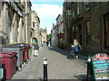
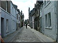
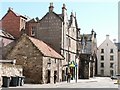
Photos of St Andrews


Area Information
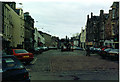
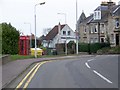
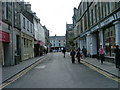
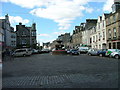
St Andrews is a compact built-up area in Scotland, spanning 4.8 km², with a character shaped by its proximity to RAF Leuchars and Leuchars Railway Station. The area is accessible via a single railway station and a nearby airport, making it a practical choice for those needing transport links. While the broadband score is modest at 48, mobile coverage is strong, scoring 84, which supports everyday connectivity. The community benefits from five retail outlets, including M&S St, Aldi St, and Spar, offering convenience for daily errands. St Andrews is a place where practicality meets proximity, with amenities within walking or short driving distance. Its size and layout suggest a tightly knit environment, ideal for those seeking a balance between urban and rural living. The area’s appeal lies in its straightforward infrastructure and the presence of key services, making it a viable option for buyers prioritising functionality over sprawling landscapes.
- Area Type
- Built Up Area 250
- Area Size
- 4.8 km²
- Population
- Not available
- Population Density
- Not available
Residents of St Andrews have access to a range of nearby amenities that shape daily life. The five retail outlets, including M&S St and Aldi St, provide essential shopping options, while Spar offers convenience for quick purchases. The presence of RAF Leuchars and Leuchars Railway Station adds to the area’s practicality, serving both commuters and those needing regional travel. Though the data does not specify parks or leisure facilities, the compact size of the area suggests a focus on immediate, walkable access to services. The character of St Andrews is defined by its efficiency, with amenities arranged to meet the needs of a community that values accessibility over expansive recreational spaces.
Amenities
Schools
| Rank | School | Type | Entry gender | Ages |
|---|
Explore more schools in this area
Go to Schools tabDemographics
Household Size
Accommodation Type
Tenure
Ethnic Group
Religion
Household Composition
Age
Household Deprivation
NS-SEC
Explore more demographic insights in this area
Go to Demographics tabPlanning
Planning Constraints
- Crime RiskPremium