Area Overview for Kinghorn
Photos of Kinghorn


Area Information
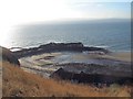
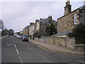
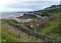
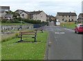
Kinghorn is a compact town in Scotland with a built-up area of just 1.0 km². This small footprint means daily life often revolves around a concentrated centre where residents can walk to many essentials. You will find a close-knit community where lanes in the built-up area connect historic buildings with modern homes. Living in Kinghorn offers a specific character defined by its size and the immediate access to the Firth of Forth. The town sits on the northern bank of the Forth Estuary, positioning you within commuting distance of larger Scottish cities while maintaining a distinct local identity. Homes in Kinghorn are nestled near the sea walls and ancient castle ruins, creating a setting that feels both established and intimate. Your daily routine likely involves navigating the compact street network to reach local shops or the train station. The small size of the settlement means noise and activity are visible aspects of living here rather than distant occurrences. You are part of a community where the physical boundaries are clear, making it easy to know your surroundings. This compact nature appeals to those seeking a town feeling without the overwhelming scale of a major city.
- Area Type
- Built Up Area 250
- Area Size
- 1.0 km²
- Population
- Not available
- Population Density
- Not available
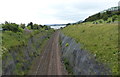
Living in Kinghorn provides convenient access to specific amenities within a short practical radius. You can walk to the Co-op Kinghorn for groceries and essentials, or travel a few miles to the Morisons Linktown and Co-op Burntisland for a wider selection. Local rail travel begins at Kinghorn Railway Station, connecting you directly to Burntisland Railway Station and Kirkcaldy Railway Station for broader travel across Scotland. If boating is part of your lifestyle, you have ready access to the Inchcolm Island Ferry Landing and the Leith Newhaven Harbour Ferry Landing. The Ocean Terminal and Newhaven ferry stations offer additional transport links for those seeking coastal exploration or city breaks. You will find that零售 options are plentiful yet concentrated, reducing the need for long car journeys. These named venues form the backbone of daily shopping and transport routines for residents. The proximity of these facilities means your weekends and evenings are planned around accessible destinations rather than distant out-of-town complexes. This distribution of amenities supports a countryside lifestyle with towns-centre convenience.
Amenities
Schools
| Rank | School | Type | Entry gender | Ages |
|---|
Explore more schools in this area
Go to Schools tabDemographics
The community in Kinghorn is defined by specific household compositions and accommodation types that shape the social fabric. You will find a mix of families and individuals living within the town's limited boundaries. The area supports a variety of home ownership levels, though exact percentages require verification against the latest census figures for the specific year. Residents utilize different accommodation types, ranging from traditional stone cottages to more modern developments suited to the local terrain. The population diversity reflects the broader Scottish demographic trends, with age profiles influencing local service needs and community activities. Deprivation levels in Kinghorn provide context for the general standard of living and access to resources you might expect as a resident. These factors combine to create a neighbourhood where long-term residents and newer arrivals coexist in a shared space. The small size of the 1.0 km² built-up area ensures that community interaction remains a functional part of daily life. You will encounter neighbours who know the local history and those who are settling into this specific slice of Fife coastal life.
Household Size
Accommodation Type
Tenure
Ethnic Group
Religion
Household Composition
Age
Household Deprivation
NS-SEC
Explore more demographic insights in this area
Go to Demographics tabPlanning
Planning Constraints
- Crime RiskPremium