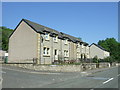
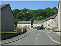
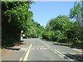
Area Overview for High Valleyfield

Valleyfield Pit Disaster Memorial in High Valleyfield
National Cycle Network route 76 in High Valleyfield
Railway Line towards the Upper Forth in High Valleyfield
Footbridge over Railway Line in High Valleyfield
High Valleyfield near Forth View Industrial Estate in High Valleyfield
Railway at Low Valleyfield in High Valleyfield
The railway to Longannet in High Valleyfield
Footpath and NCN sign at Valleyfield in High Valleyfield
Houses on Main Street, Low Valleyfield in High Valleyfield
Beech Place, Low Valleyfield in High Valleyfield
Bus stop, Low Valleyfield in High Valleyfield
Site of Valleyfield Colliery  memorial in High Valleyfield
24 photos from this area

Area Information

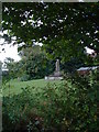
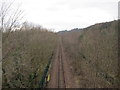
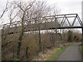
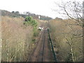
High Valleyfield is a compact built-up area in Scotland, spanning 54 hectares. Its size suggests a focused, community-oriented layout, typical of smaller towns. Living here offers a blend of practicality and accessibility, with nearby amenities that cater to daily needs. The area is well-connected by rail and metro services, including stations at Dunfermline Town and Linlithgow, which link residents to broader regional networks. Digital connectivity is strong, with a broadband score of 90 and a mobile coverage score of 84, both indicating excellent quality. This supports remote work and seamless online activity. While specific population figures are not available, the presence of multiple retail outlets—such as Co-op High, Co-op Oakley, and Co-op Scotmid—suggests a steady local economy and a community that values convenience. High Valleyfield appears to be a place where practical living meets reliable infrastructure, making it appealing for those prioritising accessibility over sprawling urban sprawl.

Area Type
Built Up Area 250
Area Size
54.0 hectares
Population
Not available
Population Density
Not available

High Valleyfield offers a range of amenities within practical reach. Retail options are plentiful, with five shops including Co-op High, Co-op Oakley, and Co-op Scotmid, providing essentials and convenience for daily errands. The presence of multiple metro stops—Bo’ness, Kinneil, and Birkhill—adds to the area’s accessibility, whether for leisure or commuting. While specific details about parks or leisure facilities are not provided, the proximity to rail stations and retail hubs suggests a lifestyle that balances practicality with community engagement. Residents can easily access nearby towns and services, making High Valleyfield suitable for those who value a mix of local amenities and regional connectivity. The area’s layout appears to prioritise ease of movement, ensuring residents can meet their needs without long journeys.

Amenities

Schools

RankA + A* %SchoolTypeEntry genderAges

Explore more schools in this area

Go to Schools tab

Demographics

Household Size

N/A
most common

Accommodation Type

N/A
most common

Tenure

N/A
majority

Ethnic Group

N/A
most common

Religion

N/A
most common

Household Composition

N/A
most common

Age

N/A
median
N/A
most common

Household Deprivation

N/A
with no deprivation

NS-SEC

N/A
in Lower managerial occupations

Explore more demographic insights in this area

Go to Demographics tab

Planning

Planning Constraints

  • Crime Risk
    Locked

Explore more planning insights in this area

Open Planning map

Frequently Asked Questions

What is the community feel like in High Valleyfield?
High Valleyfield has a compact, community-oriented layout with 54 hectares of built-up area. Retail hubs like Co-op High and Co-op Oakley suggest a focus on local convenience, while rail and metro links offer regional connectivity. The area appears practical, prioritising accessibility over sprawl.
Who typically lives in High Valleyfield?
Data on demographics is not provided, but the presence of multiple retail and transport options suggests a mix of residents seeking convenience and reliable infrastructure. The area’s size indicates a relatively small, tight-knit community.
How good is the transport and connectivity in High Valleyfield?
High Valleyfield has excellent broadband (score 90) and mobile coverage (score 84), both classified as excellent. Rail links to Dunfermline Town and Linlithgow, plus metro stops like Bo’ness and Birkhill, ensure strong regional and local connectivity.
What about safety in High Valleyfield?
Crime risk data is not available for Scotland, so no formal safety score exists. The area’s infrastructure and compact size may support a low-risk environment, but local research is recommended for a complete assessment.
What amenities are available nearby?
Residents have access to five retail outlets, including Co-op stores, and rail/metro links to Dunfermline, Linlithgow, and Birkhill. While specific leisure or park details are not provided, the area’s layout prioritises practicality and regional reach.

We use cookies to provide you with the best experience. By continuing, you agree to our Cookie Policy .