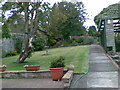
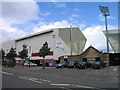
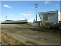
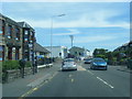
Area Overview for Dunfermline
Photos of Dunfermline


Area Information
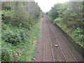
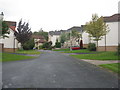
Living in Dunfermline offers you a settled life within a built-up area that occupies 16.7 km². This Scottish town balances urban convenience with manageable space, making it a practical choice for those seeking stability. You walk past a network of five railway stations, including Dunfermline Town Railway Station and Dunfermline Queen Margaret Railway Station, which anchor the town's identity. Four ferry terminals nearby, such as Rosyth Ferry Terminal and Town Pier, highlight the town's historical connection to the coast and travel. Your daily routine benefits from five retail locations like Morrisons Daily, ensuring your essential shopping needs are met without a long journey. The area is compact enough that these services feel immediate, yet large enough to avoid the congestion of a densely packed city centre. Prospective buyers considering homes in Dunfermline find an environment where infrastructure supports a straightforward lifestyle. You do not have to commute far for your essentials, and the layout encourages a pace of life that prioritises routine over frenzy. This town functions as a coherent unit where transport links and local services are integrated into the fabric of your day.
- Area Type
- Built Up Area 250
- Area Size
- 16.7 km²
- Population
- Not available
- Population Density
- Not available
Your lifestyle in Dunfermline revolves around practical amenities that are within easy practical reach. Five retail locations, predominantly Morrisons Daily stores, provide immediate access to groceries and essentials on every side of your week. This density means you do not spend half your day travelling to shops. Five railway stations, including Dunfermline Queen Margaret Railway Station, form the backbone of your leisure and business travels. You can step into a station and reach other major cities quickly. The town also features four ferry terminals such as Rosyth Ferry Terminal and Hawes Pier, offering connections that supplement the rail network. These terminals might host community events or provide scenic walkways for your regular exercise. While specific parks or leisure centres are not listed, the concentration of transport hubs and retail outlets creates a self-contained environment. You find that your day becomes a balance between local errands at Morrisons Daily and travelling via the rail network for wider exploration. Living in Dunfermline grants you a lifestyle defined by convenience and accessibility rather than luxury or exclusivity.
Amenities
Schools
| Rank | School | Type | Entry gender | Ages |
|---|
Explore more schools in this area
Go to Schools tabDemographics
The community in Dunfermline forms around specific household structures and accommodation types that define the local rhythm. While the exact age profile and household count are not detailed in current records, the presence of multiple transport hubs suggests a population accustomed to connectivity. Five notable rail stations indicate a diverse range of residents who rely on public transport for their daily movements. The area also hosts significant retail presence with entities like Morrisons Daily appearing five times in local amenity records, hinting at a customer base with consistent shopping habits. Residents access four distinct ferry terminals, including Rosyth Ferry Terminal and Hawes Pier, showing a community linked to both mainland travel and maritime history. You will find that the demographics aqui reflect a typical built-up area with established routines rather than transient trends. The five railway stations serve not just commuters but also residents with varied travel needs, from daily school runs to weekend excursions. This transport density suggests a population spread across different age groups and employment statuses. Homes in Dunfermline are occupied by people who value these established links to the wider region, creating a demographic landscape shaped by accessibility and local infrastructure.
Household Size
Accommodation Type
Tenure
Ethnic Group
Religion
Household Composition
Age
Household Deprivation
NS-SEC
Explore more demographic insights in this area
Go to Demographics tabPlanning
Planning Constraints
- Crime & SafetyPremium