Area Overview for Anstruther
Photos of Anstruther

Area Information
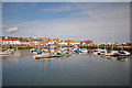
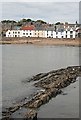
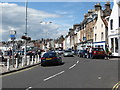
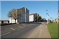
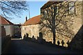
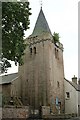
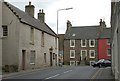
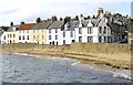
Anstruther is a compact coastal community covering just 1.3 square kilometres in Fife, Scotland. This small built-up area caters to those who prefer proximity to the sea and a manageable walking distance to local facilities. Life in Anstruther is defined by its intimate scale, which means residents can reach essential services quickly without relying on extensive car travel. The limited geographical spread creates a tight-knit environment where neighbours often know one another. You will find yourself surrounded by historic charm and maritime history, yet the infrastructure supports modern connectivity needs. Living in Anstruther offers a specific kind of coastal serenity while maintaining access to practical amenities. The town's size allows for easy navigation on foot, making it ideal for shoppers who value convenience over vast commercial parks. Your daily routine involves short journeys to the harbour or local shops rather than long commutes into larger urban centres. This layout supports a slower pace of life without isolating you from the wider world. The area functions as a self-contained settlement where the distance to key attractions is measured in minutes rather than miles. Homes in Anstruther benefit from this compact design, giving you direct access to the water's edge and the main town square. The community avoids the sprawl typical of larger regional hubs, preserving a distinct character that many UK buyers seek. You can expect a atmosphere that feels removed from the busy motorways of mainland Scotland while remaining fully connected to national networks. This balance between isolation and accessibility defines the experience of calling this coastal town your home.
- Area Type
- Built Up Area 250
- Area Size
- 1.3 km²
- Population
- Not available
- Population Density
- Not available
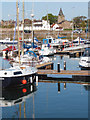
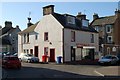
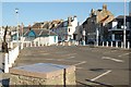
Daily life in Anstruther centres around a small but complete suite of amenities located within practical reach of every home. The presence of Anstruther Harbour provides a focal point for the community, offering historic charm alongside opportunities for maritime activities and leisurely waterfront walks. This Harbour is not merely a port but a central landmark that defines the character of living in Anstruther. Residents often enjoy views of boats and the water from their front gardens, integrating the sea into their daily routine. Retail options are concentrated and convenient, with two available outlets serving the local population. Co-op Anstruther and Co-op Crail are located within easy travelling distance, ensuring you can access fresh groceries, household essentials, and daily necessities without significant disruption to your schedule. These two stores cater to varied needs, providing choice when shopping for sustenance and home goods. The proximity of these retail points means you can complete weekly shopping in a single, short trip. Beyond commerce, the lifestyle is enriched by the natural environment and local history accessible from every street. The small area size ensures that significant destinations remain close, reducing the need for a car for basic tasks. Dining and leisure often revolve around the harbour side or local pubs where the community gathers. This concentration of facilities creates a convenient ecosystem where everything required for daily life is nearby. Living in Anstruther offers a simplified existence where the essentials are just steps away.
Amenities
Schools
| Rank | School | Type | Entry gender | Ages |
|---|
Explore more schools in this area
Go to Schools tabDemographics
The demographic profile of Anstruther reveals a community shaped by its coastal location and limited land area. While specific population figures and age breakdowns are not detailed in current records, the small total area of 1.3 square kilometres suggests a relatively concentrated resident base. Housing density in such a compact built-up area often results in mixed household types, potentially including both families and retirees attracted to the seaside setting. The mix of local residents and people working in nearby Fife or Edinburgh drives the local economy and social fabric. Accommodation diversity in Anstruther reflects the varied needs of those living in this exclusive Scottish locale. The limited space means development has historically focused on efficient use of land, leading to a range of property ages and styles. Some residents may live in traditional stone cottages near the harbour, while others occupy newer developments designed for modern living. The community likely includes long-term locals who have built lives around the town's rhythms alongside newcomers drawn by the quality of life. Deprivation indicators for this specific area are not currently quantified in available datasets, preventing a precise ranking against national standards. However, living in a small, specialised town like Anstruther often correlates with stable communities where social services and informal support networks play a significant role. The nature of the local economy, centred on tourism, mariculture, and public sector employment, typically provides steady opportunities. Understanding who lives here requires observing the daily interactions in the streets near Anstruther Harbour and the local retail parks.
Household Size
Accommodation Type
Tenure
Ethnic Group
Religion
Household Composition
Age
Household Deprivation
NS-SEC
Explore more demographic insights in this area
Go to Demographics tabPlanning
Planning Constraints
- Crime & SafetyPremium