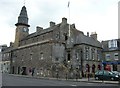
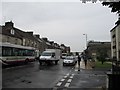
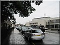
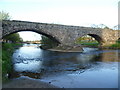
Area Overview for Musselburgh
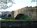
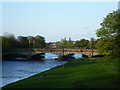
Photos of Musselburgh


Area Information
Musselburgh is a compact built-up area covering 4.5 km² in Scotland. This small footprint creates a dense community where residents are close to their daily needs. The area functions as a distinct town environment rather than a sprawling suburb. You will find that the locality offers a concentrated living experience within a manageable size. Daily life here revolves around the immediate vicinity, allowing you to manage commutes and errands with ease. The area's identity is tied to its urban character, providing a sense of enclosure that many larger regions lack. Living in Musselburgh means navigating a territory where boundaries are clear and the environment is defined by its established town plan. This density supports a strong sense of local identity while maintaining the functionality of a modern settlement. Prospective buyers appreciate that the area is self-contained enough to reduce travel time yet positioned within a broader transport network. The physical scale of 4.5 square kilometres ensures that infrastructure can serve the population efficiently without excessive strain. You gain access to a town centre lifestyle without the isolation of a rural location. This balance is central to the appeal of the neighbourhood for those seeking a stable, urban Scottish setting.
- Area Type
- Built Up Area 250
- Area Size
- 4.5 km²
- Population
- Not available
- Population Density
- Not available
Shopping and transport options are within easy reach for residents of Musselburgh. You have access to five major retail outlets, including Tesco Musselburgh, Morrisons Daily, and Farmfoods Musselborough. These stores provide comprehensive grocery and daily shopping needs without long travel times. All five are located within practical distance, ensuring convenient access to fresh food and household essentials. Five railway stations serve the area, offering direct links to Musselburgh Railway Station, Wallyford Railway Station, and Newcraighall Railway Station. This rail network allows you to commute efficiently to Edinburgh and other connected destinations. Additionally, the local bus network is extensive, with five distinct routes operating through Mossend, Foot of the Walk, and Balfour Street. These bus lines offer flexible public transport for those who do not drive. You can combine rail and bus travel to reach your destination quickly. The concentration of five rail termini indicates a major transport hub for the town. Retail diversity ensures you can find specialist shops alongside supermarkets nearby. Public transport density means you do not rely solely on a private vehicle. Living in Musselburgh provides a lifestyle where essential services and regional connections are immediately accessible.
Amenities
Schools
| Rank | School | Type | Entry gender | Ages |
|---|
Explore more schools in this area
Go to Schools tabDemographics
Demographic data for the built-up area of Musselburgh is not included in the available records. Consequently, it is impossible to state specific figures regarding the age profile or household composition. Without these statistics, you cannot determine the exact proportion of families, singles, or empty nesters residing in the town. There is no information available on the percentage of the population that identifies with diverse backgrounds or ethnicities. Given the absence of specific numbers, any claim about the diversity or age distribution would be unfounded. You should rely on general observations of the town's character rather than speculative demographic extrapolations. The lack of published data on these specific metrics means that potential buyers cannot assess the precise make-up of the community through statistical measures. Information regarding deprivation levels and income distribution is similarly absent from the current dataset. This gap prevents a detailed analysis of economic disparities within the locality. You must accept that the detailed human profile of Musselburgh remains unquantified in the provided sources. While the area is a settled built-up zone, the specific numbers describing its inhabitants are not accessible. This limitation underscores the need for local engagement rather than reliance on remote data summaries for a full understanding of the residents.
Household Size
Accommodation Type
Tenure
Ethnic Group
Religion
Household Composition
Age
Household Deprivation
NS-SEC
Explore more demographic insights in this area
Go to Demographics tabPlanning
Planning Constraints
- Crime RiskPremium