Area Overview for Haddington and Lammermuir Ward
Photos of Haddington and Lammermuir Ward


Area Information
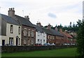
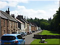
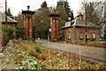
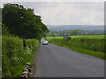
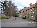
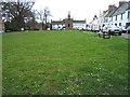
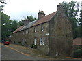
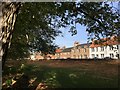
Haddington and Lammermuir Ward stands as the geographically largest district within East Lothian Council, covering a substantial 319 square kilometres. Located centrally within the county, this multi-member electoral ward elects four councillors and includes the historic town of Haddington alongside the accessible small towns of Pencaitland and Ormiston. As of the 2020 mid-year estimate, the population reached 19,164 residents, representing 17.8% of the entire East Lothian population. The area hosts 8,610 dwellings, creating a landscape defined by a mix of urban stability and rural access. You will find that this ward comprises nearly 60% accessible small towns and roughly 40% accessible rural areas. This distribution offers a variety of living styles within a single administrative boundary. The ward is anchored by Haddington, a town known for its numerous listed buildings including premises on Church Street and The Kennels. Daily life here balances the convenience of a market town with the quiet of the surrounding countryside. Residents benefit from a significant share of the local population compared to the wider council area, ensuring local services remain relevant to a substantial community. Whether you seek the pace of a small town or the seclusion of the Lammermuir hills, the ward provides both options without the isolation often found in purely rural districts.
- Area Type
- District Borough Unitary Ward
- Area Size
- 319.0 km²
- Population
- Not available
- Population Density
- Not available
Demographics
The community in Haddington and Lammermuir Ward reflects a balance of economic stability and ongoing challenges. Income deprivation currently affects 8.1% of the population, a figure that sits below the East Lothian average of 10.2% and Scotland's 12.1%. Similarly, employment deprivation impacts 7.7% of residents, remaining lower than the council and national averages. These statistics suggest a relatively healthy economic base compared to the broader Scottish context. However, the onset of the pandemic introduced a notable shift in financial reliance, with 1,401 residents claiming Universal Credit in October 2021. This number represented a 63.5% rise compared to pre-COVID levels, highlighting specific vulnerabilities within the local household base. Safety remains a high priority for the community, as 94% of residents reported feeling safe walking in their neighbourhood during the 2019 Residents Survey. Despite this confidence, infrastructure maintenance is a key concern for daily living. Thirty-one per cent of residents identified road and pavement repairs as the top priority for improvement, a figure that was the highest across all wards in East Lothian. Traffic congestion ranked second, accounting for 11% of concerns. The demographic profile indicates a settled population where quality of life hinges largely on the condition of local infrastructure rather than fluctuating crime rates or severe economic instability.
Household Size
Accommodation Type
Tenure
Ethnic Group
Religion
Household Composition
Age
Household Deprivation
NS-SEC
Explore more demographic insights in this area
Go to Demographics tabPlanning
Planning Constraints
- Flood RiskPremium
- Ramsar Wetland SitesPremium
- Area of Outstanding Natural BeautyPremium
- Protected Nature ReservePremium
- Protected WoodlandPremium
- Crime RiskPremium