Area Overview for Gullane
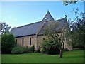
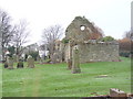
Photos of Gullane


Area Information
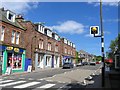
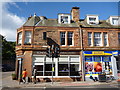
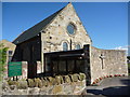
Gullane is a seaside village and town situated on the southern shore of the Firth of Forth in East Lothian. With a population of 2,810 recorded in 2020, it occupies 1.2 km² of the Scottish coast approximately 20 miles east of Edinburgh. You will find the village defined by a picturesque coastal setting, historical charm, and world-class golf facilities. Its location along the scenic A198 route through the East Lothian countryside makes it a distinct commuter village for Edinburgh, despite some transport challenges. Residents enjoy a strong sense of community while living in an area characterised by a blend of rich history and contemporary amenities. The village retains its architectural heritage through conservation area status and well-preserved buildings. You will experience a tranquil atmosphere alongside a lively community vibe driven by local events. World-class golf venues like Muirfield and Gullane Golf Club form part of the daily landscape. The area offers a historical backdrop with St. Andrew's Church dating back to the ninth century, now standing as a roofless medieval ruin. Gullane presents itself as a place where the past meets the present, offering a specific lifestyle for those seeking coastal living near a major city without being overwhelmed by it.
- Area Type
- Built Up Area 250
- Area Size
- 1.2 km²
- Population
- Not available
- Population Density
- Not available
Living in Gullane offers immediate access to practical amenities within a concise radius. You have five retail options within practical reach, including the Co-op Gullane, Co-op North, and Aldi North. These shops provide daily necessities without requiring long trips into other towns. For rail travel, three stations serve the broader area: Drem Railway Station, North Berwick Railway Station, and Longniddry Railway Station. The North Berwick Harbour offers one ferry connection for coastal access. Your lifestyle is shaped by a strong economy driven by golf and tourism. Muirfield and Gullane Golf Club anchor the leisure scene, offering incredible sporting grounds. Dining choices include the award-winning Chez Roux at the Greywalls Hotel and various traditional pubs. The village hosts year-round events such as the Gullane Music Festival and the East Lothian Food & Drink Festival, which support local commerce and provide social engagement. A village hall serves as a community hub, and a primary school is present within the area. Local children travel five miles by road to secondary education in North Berwick. Gullane Bents, a beautiful sandy beach, provides a venue for leisurely walks and water sports. This blend of historical landmarks like St. Andrew's Church and modern conveniences creates a comprehensive living environment.
Amenities
Schools
| Rank | School | Type | Entry gender | Ages |
|---|
Explore more schools in this area
Go to Schools tabDemographics
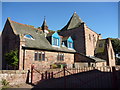
The community in Gullane combines residents attracted by its appeal as a commuter village with a higher than average percentage of elderly people locally. This demographic mix suggests a settlement where young families and commuters share space with established long-term residents. The population data indicates a stable setting where residents actively participate in community events and local groups. You will find a village that balances a tranquil atmosphere with a lively community vibe through this interactive social fabric. The historical significance of the area influences the character of the people living here, with buildings designed by figures like Sir Edwin Lutyens and gardens created by Gertrude Jekyll shaping the environment. The local population enjoys a strong connection to the area, evidenced by their active involvement in local governance and social organisations. While specific household types or ownership percentages are not detailed in the current records, the nature of the commuter village suggests a workforce supporting the Edinburgh economy alongside retirees drawn to the coast. The area fosters resilience and neighbourly bonds, making it a distinct social entity within East Lothian.
Household Size
Accommodation Type
Tenure
Ethnic Group
Religion
Household Composition
Age
Household Deprivation
NS-SEC
Explore more demographic insights in this area
Go to Demographics tabPlanning
Planning Constraints
- Crime RiskPremium