Area Overview for DD1 1UJ
Photos of DD1 1UJ


Area Information
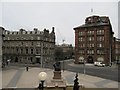
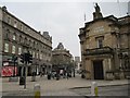
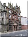
DD1 1UJ is a small residential cluster nestled in Dundee, Scotland, a city with a rich industrial heritage and a modern, forward-thinking identity. Situated on the north bank of the River Tay, the area benefits from proximity to the city’s revitalised urban core, which now thrives as a hub for education, life sciences, and digital media. The postcode lies within a historically significant region, with remnants of medieval defences and Victorian architecture still visible in the city centre. Dundee’s transformation from a jute-industry stronghold to a centre for innovation is evident here, with institutions like the University of Dundee and Abertay University anchoring the local economy. Residents enjoy a blend of urban convenience and proximity to natural features, such as the Tay River and surrounding hills. The area’s compact size means daily life is centred around nearby amenities, including supermarkets, rail stations, and cultural landmarks, creating a self-contained yet connected community.
- Area Type
- Postcode
- Area Size
- Not available
- Population
- Not available
- Population Density
- Not available
House Prices in DD1 1UJ
No properties found in this postcode.
Energy Efficiency in DD1 1UJ
Living in DD1 1UJ offers access to a range of amenities within practical reach. Supermarkets such as Morrisons Daily Dundee, Tesco Murraygate, and Iceland Dundee provide daily shopping convenience. The area’s rail network includes Dundee Railway Station, Invergowrie Railway Station, and Broughty Ferry Railway Station, facilitating travel to nearby towns and cities. While the postcode does not have its own airport, Dundee City Airport and Dundee Airport are within reach, offering regional flight connections. The city’s cultural and educational institutions, including the University of Dundee and Abertay University, contribute to a dynamic social environment. Though the data does not specify parks or leisure facilities directly, Dundee’s historic landmarks, such as the Tay Rail Bridge and the city’s Victorian-era streets, are accessible via local transport, enriching the area’s character.
Amenities
Schools
| Rank | School | Type | Entry gender | Ages |
|---|
Explore more schools in this area
Go to Schools tabDemographics
Household Size
Accommodation Type
Tenure
Ethnic Group
Religion
Household Composition
Age
Household Deprivation
NS-SEC
Explore more demographic insights in this area
Go to Demographics tabPlanning
Planning Constraints
- Flood RiskPremium
- Ramsar Wetland SitesPremium
- Area of Outstanding Natural BeautyPremium
- Protected Nature ReservePremium
- Protected WoodlandPremium
- Crime RiskPremium