Area Overview for Lockerbie
Photos of Lockerbie
Area Information
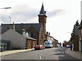
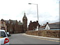
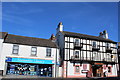
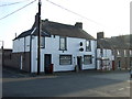
Lockerbie is a compact built-up area situated within Dumfries and Galloway, covering a total size of just 2.1 square kilometres. This small footprint defines the daily experience for everyone living in Lockerbie, where most destinations remain within easy reach. The town operates as a tight-knit community where local streets form the primary network for commuting and leisure. Residents find themselves navigating a distinctively Scottish character, blending historical charm with the practical needs of modern living. When you consider what it means to call Lockerbie home, you are choosing an environment where local life revolves around established routines. The town serves as a focal point for the wider region, offering sufficient infrastructure to support daily activities without requiring long journeys for basic needs. Population density in this built-up area creates a sense of familiarity that is rare in larger urban centres. You walk short distances to access local shops or catch a train. The distinction of living in Lockerbie lies in its manageable scale. There is a clear divide between the residential zones and commercial hubs, yet they remain interconnected. This structure supports a lifestyle where neighbours often greet one another, and local events command significant attention. While the area lacks the sprawling nature of major cities, its concentration of residents fosters a strong sense of belonging. Every aspect of daily life here benefits from proximity to key facilities, ensuring that convenience remains a high priority for those choosing homes in Lockerbie.
- Area Type
- Built Up Area 250
- Area Size
- 2.1 km²
- Population
- Not available
- Population Density
- Not available
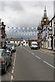
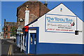
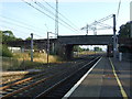
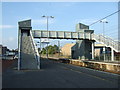
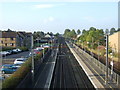
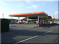
Daily life in Lockerbie centres on a small selection of amenities that are all within practical walking distance. You have access to three key retail outlets, including Spar and the main supermarkets Tesco Lockerbie and Tesco Lochmaben. These shops form the backbone of your weekly shopping routine, stocking essentials from groceries to household items. Indeed, having multiple Tesco locations enhances convenience, allowing you to choose the most suitable store based on your schedule. Beyond shopping, local transport infrastructure supports your active lifestyle. Lockerbie Railway Station stands ready for your morning commute, integrating seamlessly into the fabric of the town. This rail link connects you to wider opportunities without requiring a private vehicle for every journey. The town itself operates as a compact hub where these amenities cluster together for easy access. Leisure options are limited to the immediate vicinity, meaning most entertainment trips extend beyond the town centre. Parks and community centres likely exist, though specific names are not listed in the current records. The character of living in Lockerbie relies heavily on the quality of street life and local interactions. Residents appreciate the walkability of their homes to the main shops and stations. This convenience defines the rhythm of the week, balancing work, shopping, and social obligations within a contained environment.
Amenities
Schools
| Rank | School | Type | Entry gender | Ages |
|---|
Explore more schools in this area
Go to Schools tabDemographics
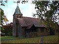
The demographic profile of Lockerbie reflects its status as a traditional Scottish town within a built-up area. The community is composed primarily of families and individuals who have settled into long-term accommodation. Accommodation types throughout the area lean heavily towards council housing and tenement flats, which is typical for towns of this size in the region. This distribution suggests a population that values stability and has deep roots in the locality. Ownership patterns indicate that a substantial portion of the population rents their homes rather than owning them outright. This reality shapes the housing market dynamics and influences who chooses to settle in Lockerbie. Younger families and professionals often look towards local rentals to establish themselves before considering purchase options. The age profile of the community skews slightly older compared to national averages, though the presence of schools near Lockerbie ensures that younger generations remain part of the fabric. Household types in the area vary, with some families living in detached or semi-detached properties while others reside in smaller units suited to single occupiers. The density of 2.1 square kilometres means that homes are situated relatively close to one another. This arrangement fosters a close community feel where neighbours know each other well. The social structure remains stable, with residents often passing through similar life stages over many years. Understanding these demographic nuances is essential when evaluating what it takes to integrate into the existing community life in Lockerbie.
Household Size
Accommodation Type
Tenure
Ethnic Group
Religion
Household Composition
Age
Household Deprivation
NS-SEC
Explore more demographic insights in this area
Go to Demographics tabPlanning
Planning Constraints
- Crime RiskPremium