Area Overview for Kirkconnel
Photos of Kirkconnel

Area Information
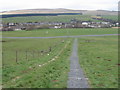
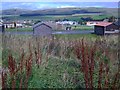
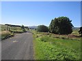
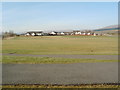
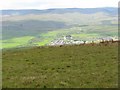
Living in Kirkconnel offers a settled existence within a built-up area that spans 75.7 hectares. This community sits firmly within Scotland, providing a distinct environment for those seeking a rural or semi-rural pace of life. The area functions as a defined locality rather than a sprawling city, which shapes the daily rhythm for residents. You will find that life here revolves around a compact footprint, meaning most essential services require a short drive or a bus journey rather than a walk. The character of Kirkconnel is defined by its modest scale, making it suitable for families or individuals who prefer a quieter setting away from major urban centres. Homes in Kirkconnel cater to those who value space and proximity to the surrounding Scottish landscape. The community does not boast large centres of high-density living, instead maintaining a spread that allows for gardens and open surroundings. When you consider living in this locality, you are choosing an environment where the focus remains on stability and local connections. The area size suggests a neighbourhood where locals know one another, and activity centres on practical needs rather than constant nightlife. This is a place where you build a life around access to nearby rail links and essential retail, rather than relying on a central high street within the village itself.
- Area Type
- Built Up Area 250
- Area Size
- 75.7 hectares
- Population
- Not available
- Population Density
- Not available
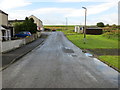
Your daily life in Kirkconnel centres on a few key convenience points that define the local shopping and transport experience. With only 75.7 hectares of land, everything you need is within a manageable distance, yet the village lacks the extensive high street of a larger town. The nearest retail option is a Spar, which provides essential groceries and daily necessities. You will make this short trip for your weekly shop, ensuring you stay connected to community life without spending hours in traffic. Beyond the Spar, the rail connectivity anchors your lifestyle through two specific stations. Kirkconnel Railway Station and Sanquhar Railway Station offer direct access to wider networks, meaning you do not need to travel far to reach a transport hub. For leisure and outdoor activities, you must look slightly beyond the immediate village boundary. The built-up nature of Kirkconnel means most parks and leisure centres are in nearby towns rather than inside the 75.7 hectares. However, the location is ideal for those who enjoy the Scottish landscape. You can combine local life with trips to larger centres for dining, cinema, or major sports events. This mix of local simplicity and regional accessibility makes it suitable for active individuals who value time. The presence of these two railway stations ensures you never feel cut off, while the local Spar keeps your daily routine practical and efficient. Kirkconnel works best for you if you plan your weekends around travel to bigger towns for broader entertainment options.
Amenities
Schools
| Rank | School | Type | Entry gender | Ages |
|---|
Explore more schools in this area
Go to Schools tabDemographics
The demographics of Kirkconnel reflect a community with specific housing and family dynamics. While exact population figures are not listed in the current records, the area intensity suggests a mix of households typical for a Scottish built-up zone of this size. Residents here likely include a blend of working families and individuals who have chosen this location for its affordability or connection to the wider rural economy. The community structure supports both owner-occupiers and households that rent, though the balance varies across the housing stock. Local diversity in Kirkconnel is shaped by the types of accommodation available within the 75.7 hectares. You will encounter single-family homes and smaller terraced properties depending on the specific plot within the built-up area. The age profile of the residents aligns with trends in similar Scottish settlements where families and retired individuals often share the local services. Your potential neighbours will range from those commuting to larger towns to those working locally in agriculture or tourism. Understanding the household types in Kirkconnel helps you anticipate the community feel. The area attracts people who prioritise a stable home over urban convenience, creating a neighbourly atmosphere where residents support local institutions like the nearby railway station.
Household Size
Accommodation Type
Tenure
Ethnic Group
Religion
Household Composition
Age
Household Deprivation
NS-SEC
Explore more demographic insights in this area
Go to Demographics tabPlanning
Planning Constraints
- Crime RiskPremium