Area Overview for Newmilns
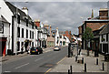
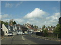
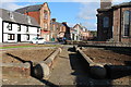
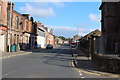
Photos of Newmilns


Area Information
Newmilns is a built-up area in Scotland, covering 89.6 hectares. It is a compact town with a distinct character, positioned to offer a balance between small-town charm and practical amenities. The area is served by nearby retail hubs, including Tesco Galston, Co-op Galston, and Co-op Darvel, which provide everyday convenience. While the population size isn’t specified, the presence of these amenities suggests a community that values accessibility. Newmilns is not a sprawling metropolis but a place where daily life revolves around local services and a sense of familiarity. Residents likely benefit from the proximity to these retail outlets, which support routine needs without requiring long commutes. The area’s size and layout suggest a focus on close-knit living, with a practical approach to housing and infrastructure. For those considering living in Newmilns, the blend of local shops and a manageable footprint could appeal to those seeking a quieter, more self-contained environment.
- Area Type
- Built Up Area 250
- Area Size
- 89.6 hectares
- Population
- Not available
- Population Density
- Not available
Newmilns offers a range of nearby amenities that support a practical lifestyle. Within practical reach are retail outlets such as Tesco Galston, Co-op Galston, and Co-op Darvel, ensuring residents have access to essential shopping and services. These stores cater to daily needs, from groceries to household items, reducing the necessity for long trips to larger centres. While the area doesn’t detail parks or leisure facilities, the presence of multiple retail options suggests a focus on convenience. The character of Newmilns appears to be one of accessibility, with amenities positioned to serve local residents efficiently. For those who enjoy a self-contained lifestyle, the nearby shops provide a sense of community and ease, allowing residents to manage errands and daily routines without venturing far. The availability of these services likely contributes to a sense of stability, making Newmilns an attractive option for those valuing practicality over extensive leisure options.
Amenities
Schools
| Rank | School | Type | Entry gender | Ages |
|---|
Explore more schools in this area
Go to Schools tabDemographics
Household Size
Accommodation Type
Tenure
Ethnic Group
Religion
Household Composition
Age
Household Deprivation
NS-SEC
Explore more demographic insights in this area
Go to Demographics tabPlanning
Planning Constraints
- Crime RiskPremium