Area Overview for Largs
Photos of Largs
Area Information
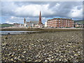
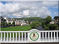
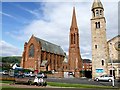
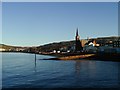
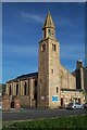
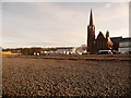
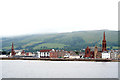
Living in Largs offers a coastal lifestyle defined by the west coast town's position on the Firth of Clyde. This built-up area occupies 2.9 square kilometres and is characterised by pleasant pebble beaches and a historic seafront pier. Human activity in the locality dates back to the Neolithic era, with a burial chamber in Douglas Park dating from around 3000 BC. The town gained significant historical prominence during the Battle of Largs in 1263. Scottish forces under Alexander III engaged Norwegian forces, but a fierce storm on 30 September 1263 damaged King Haakon IV's fleet. Many longships were forced ashore at Largs, effectively ending Norse claims over the Western Isles. A modern landmark commemorates this event, with the Pencil monument standing as a reminder to visitors and residents. You may also encounter the Largs war memorial, designed by Sir Robert Lorimer and dating from 1920. The town combines its heritage with a contemporary identity as a popular seaside resort. Today, Largs is particularly famous for its ice cream shops. The annual Vikingar festival held in early September markets the area's historic Viking connections. You can explore the Vikingar centre at Barrfields, which was formerly the base for flying boats during World War II.
- Area Type
- Built Up Area 250
- Area Size
- 2.9 km²
- Population
- Not available
- Population Density
- Not available
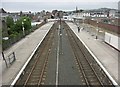
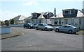
Your daily life in Largs benefits from a concentration of retail and transport amenities within practical reach. For your shopping needs, three major supermarkets are situated nearby: Morrisons Daily, Farmfoods Largs, and Spar. These venues ensure you can access essentials without undertaking long journeys to larger shopping centres. Transport convenience is a standout feature, with easy access to three railway stations. Largs Railway Station, Fairlie Railway Station, and Wemyss Bay Railway Station connect you to the wider network. Beyond the railway, three ferry terminals serve the community, including Cumbrae Ferry Terminal, Fairlie Ferry Terminal, and Millport Pier Ferry Terminal. These maritime hubs link Largs to the islands of Cumbrae, Fairlie, and Millport, fostering strong local connections. The central area around the V&A Archive includes the iconic seafront pier, which remains a focal point for visitors and locals alike. The town's character as a seaside resort is reinforced by the significant number of ice cream shops. Historic sites add depth to your environment, with the Vikingar centre at Barrfields offering cultural insights. The BBC Radio Scotland transmitter and television mast atop the Roker Point lighthouse contribute to the town's skyline. This mix of retail, transport, and leisure creates a self-contained lifestyle centred on the coast.
Amenities
Schools
| Rank | School | Type | Entry gender | Ages |
|---|
Explore more schools in this area
Go to Schools tabDemographics
The provided data sets do not include specific figures for age profiles, household types, home ownership levels, or diversity within the community in Largs. Without these specific statistics, a detailed breakdown of the demographic makeup cannot be presented. Similarly, there is no available data regarding the proportion of owner-occupied versus rental properties or the specific mix of accommodation types such as flats or houses. The absence of this information prevents any concrete conclusions about the character of the residents or the level of tenure security in the area. Deprivation indices are also not included in the available information, meaning the economic quality of life cannot be quantified based on the provided sources. While the area has a rich history and a visible tourist economy, the statistical profile of the people living in Largs remains unrecorded in this dataset. Prospective buyers seeking data on age distribution, family structures, or school attendance rates will find these figures are not available in the current records. The town's reputation as a seaside resort influences its character, but precise demographic numbers are not part of the provided information.
Household Size
Accommodation Type
Tenure
Ethnic Group
Religion
Household Composition
Age
Household Deprivation
NS-SEC
Explore more demographic insights in this area
Go to Demographics tabPlanning
Planning Constraints
- Crime RiskPremium