Area Overview for KA30 8DR
Photos of KA30 8DR


Area Information
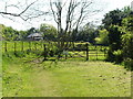
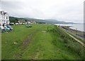
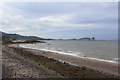
KA30 8DR is a small residential cluster nestled in North Ayrshire, Scotland, within the broader Ayrshire and Arran lieutenancy area. This postcode falls in a region renowned for its coastal landscapes and island communities, with the nearby Isle of Arran offering a blend of natural beauty and historical significance. The area covers just 1.7 hectares, reflecting its compact, intimate character. Residents here benefit from proximity to both mainland Scotland and the Isle of Arran, which is often described as “Scotland in Miniature.” The region’s appeal lies in its mix of traditional village life and accessible amenities, from local shops to transport links. With the Firth of Clyde nearby, the area is well-positioned for those seeking a balance between rural tranquillity and coastal connectivity. The presence of nearby towns like Largs and the historic town of Ayr, with its Royal Burgh heritage, adds to the area’s cultural and historical depth. Living in KA30 8DR means being part of a community that values natural surroundings, heritage, and practical accessibility.
- Area Type
- Postcode
- Area Size
- 1.7 hectares
- Population
- Not available
- Population Density
- Not available
House Prices in KA30 8DR
Showing 4 properties
| Address | Type | Beds | Baths | Last Sale Price | Last Sale Date | |
|---|---|---|---|---|---|---|
| 2 Broomfield Place, Largs, KA30 8DR | Semi-detached | - | - | - | - | |
| 4 Broomfield Place, Largs, KA30 8DR | house | - | - | - | - | |
| 1 Broomfield Place, Largs, KA30 8DR | Flat | - | - | - | - | |
| 5 Broomfield Place, Largs, KA30 8DR | house | - | - | - | - |
Energy Efficiency in KA30 8DR
Daily life in KA30 8DR is shaped by its proximity to essential amenities and natural surroundings. The area’s retail options include major supermarkets like Morrisons Largs, Spar, and Tesco Largs, ensuring convenience for grocery shopping. For those seeking travel beyond the immediate area, the nearby railway stations and ferry terminals provide easy access to the Isle of Arran, mainland Scotland, and coastal destinations. The region’s appeal lies in its blend of practicality and scenic beauty, with the Isle of Arran offering hiking, wildlife, and historical sites. Residents can enjoy both the quiet of a small residential cluster and the vibrancy of nearby towns. The combination of local shops, transport links, and natural landscapes creates a lifestyle that balances simplicity with accessibility, ideal for those who value both community and adventure.
Amenities
Schools
| Rank | School | Type | Entry gender | Ages |
|---|
Explore more schools in this area
Go to Schools tabDemographics
say to use exact figures from the data. Since there's no data on demographics, I can't write that section. But the user might have made a mistake. However, the user's critical rules say if you don't have data, don't mention it. So I should skip the demographics section. But the user's instructions say to generate all sections. Wait, maybe the user expects me to use the areaResearch's overview, which mentions the lieutenancy area and the council areas, but that's not demographic data. I think I have to omit the demographics section as there's no data. But the user included it in the instructions. Hmm, this is confusing. Let me proceed and see. For the propertyMarket section, the data doesn't have specific property market stats like home ownership percentages or accommodation types. The areaResearch mentions the area includes coastal settlements and island communities, but no specific property data. So again, no data to use. But the user's instructions say to use the exact figures. Therefore, I can't write the propertyMarket section. But the user might have intended for me to use the nearbyAmenities and other info. Wait, the nearbyAmenities have retail, rail, ferry. Maybe the property market is inferred from the nearbyAmenities? Not sure. The user's instructions say to use the data provided, so if there's no data, skip. So maybe the propertyMarket section can't be written. But the user included it in the instructions. This is tricky. Maybe I need to check again. Looking at the data, the has an overview but no demographics or property stats. The have retail, rail, ferry. The have flood risk, etc. The has broadband and mobile scores. So for the propertyMarket, there's no data on home ownership, accommodation types, etc. Therefore, I can't write that section. But the user's instructions say to generate all sections. Maybe I need to proceed with the available data, even if it's not perfect. Transport section: The digitalConnectivity has broadband score 38 (which is poor) and mobile 82 (good). The nearbyAmenities include rail and ferry. So I can write about the transport options, mentioning the rail stations and ferry terminals, and the broadband and mobile scores. For the transport section, I can use the nearbyAmenities and digitalConnectivity data. Lifestyle section: The nearbyAmenities have retail (Morrisons, Spar, Tesco), rail (Largs, Fairlie, Wemyss Bay), ferry (Cumbrae, Fairlie, Millport). So I can list these specific places and describe the convenience they offer. Safety section: The assessments have flood risk (low), Ramsar, AONB, protected areas (all pass with 0 score), and crime risk data not available for Scotland. So I can mention the low flood risk and the absence of protected areas, but note that crime data isn't available for Scotland. FAQs: Need to generate 3-5 questions. Possible topics: community feel (mention nearby amenities and rail/ferry), who lives here (coastal and island communities), transport (rail and ferry options, broadband), safety (low flood risk), amenities (specific shops and transport links). Now, I need to structure each section with the available data, ensuring not to mention any gaps. For the areaSummary, I can use the areaResearch's overview, the location in North Ayrshire, proximity to Isle of Arran, and the area size. For the transport, use the digitalConnectivity and nearbyAmenities. For lifestyle, list the specific amenities. For safety, the flood risk and absence of protected areas. For FAQs, use the available data points. I think that's the approach. Let me proceed to draft each section accordingly, ensuring all data is used and no gaps are mentioned. KA30 8DR is a small residential cluster nestled in North Ayrshire, Scotland, within the broader Ayrshire and Arran lieutenancy area. This postcode falls in a region renowned for its coastal landscapes and island communities, with the nearby Isle of Arran offering a blend of natural beauty and historical significance. The area covers just 1.7 hectares, reflecting its compact, intimate character. Residents here benefit from proximity to both mainland Scotland and the Isle of Arran, which is often described as “Scotland in Miniature.” The region’s appeal lies in its mix of traditional village life and accessible amenities, from local shops to transport links. With the Firth of Clyde nearby, the area is well-positioned for those seeking a balance between rural tranquillity and coastal connectivity. The presence of nearby towns like Largs and the historic town of Ayr, with its Royal Burgh heritage, adds to the area’s cultural and historical depth. Living in KA30 8DR means being part of a community that values natural surroundings, heritage, and practical accessibility.
Household Size
Accommodation Type
Tenure
Ethnic Group
Religion
Household Composition
Age
Household Deprivation
NS-SEC
Explore more demographic insights in this area
Go to Demographics tabPlanning
Planning Constraints
- Flood RiskPremium
- Ramsar Wetland SitesPremium
- Area of Outstanding Natural BeautyPremium
- Protected Nature ReservePremium
- Protected WoodlandPremium
- Crime & SafetyPremium