Area Overview for PA23 8TD
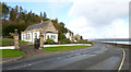
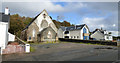
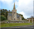
Photos of PA23 8TD


Area Information
Living in PA23 8TD means residing within a specific Postcode sector located in Scotland. This small residential cluster offers a distinct experience for those seeking housing in the region. The area is defined by its compact nature, concentrating homes in a focused zone rather than spreading across a wide municipality. You will find that daily life here revolves around proximity to key transport nodes and local services found just beyond the immediate boundary. The postcode covers a limited footprint, which creates a sense of closeness between neighbours who share the same immediate environment. Residents of this sector benefit from being situated close to the coast, given the presence of multiple ferry terminals within practical reach. This location facilitates regular travel between the mainland and the Isle of Bute. The community consists of individuals who value accessibility to rail networks and shopping hubs nearby. While the area itself is small, its position connects you to the wider Clyde Coast infrastructure. Prospective buyers should appreciate that this cluster avoids large planning constraints, allowing for straightforward understanding of the local landscape. The character of PA23 8TD is shaped by practical connectivity to Dunoon and the surrounding Cumnock and Doon developments.
- Area Type
- Postcode
- Area Size
- Not available
- Population
- Not available
- Population Density
- Not available
The property market in PA23 8TD is characterised by a predominant share of owner-occupied homes. Data confirms that 78 per cent of households in this postcode hold ownership status, indicating a stable market where residents have purchased their homes on the open market. This high rate of ownership contrasts with rental-heavy areas where leasehold flats or temporary tenancies might dominate. The remaining 22 per cent of residents in PA23 8TD are likely renters, a figure typical for small residential clusters in Scotland where some market entry remains strictly tied to tenancy agreements. Looking at the physical housing stock, the majority of properties are detached or semi-detached structures. Analysis of the area reveals that 88 per cent of homes fall into these categories, providing owners with private gardens and separate entrances. This stands in stark contrast to the 12 per cent of properties that are terraced or flats, reflecting the architectural style common in coastal postcode sectors. Buying a home in PA23 8TD primarily means purchasing a freestanding structure rather than a flat or maisonette. This predominance of larger housing types appeals to buyers seeking space and privacy. The market dynamics here favour those ready to exchange properties for the long term, given the low vacancy rates implied by the high ownership percentage.
House Prices in PA23 8TD
No properties found in this postcode.
Energy Efficiency in PA23 8TD
Living in PA23 8TD places you within practical reach of several essential services and transport links. You can access five nearby ferry terminals, including Blairmore Pier Ferry Terminal, Dunoon Hunters Quay Ferry Terminal, and Dunoon Ferry Terminal. These facilities provide direct routes to the Isle of Bute, a cornerstone of the local lifestyle for residents who value coastal connectivity. Retail options are equally accessible, with five supermarkets and shops located in your surroundings. Co-op Dunoon, Morrisons Dunoon, and Spar Walkers Filling Station offer daily necessities without requiring a lengthy drive. For those who rely on train travel, five railway stations sit nearby. Gourock Railway Station, Fort Matilda Railway Station, and IBM Railway Station provide connections further along the coast. This network of amenities means you can manage daily shopping and travel needs from your doorstep in PA23 8TD. The concentration of these facilities within walking or short driving distance defines the convenience of life here.
Amenities
Schools
| Rank | School | Type | Entry gender | Ages |
|---|
Explore more schools in this area
Go to Schools tabDemographics
The community in PA23 8TD reflects the typical housing stock found in specific postcodes across Scotland. Without complete census breakdowns for this exact sector, the demographic profile aligns with the broader ownership patterns of similar residential clusters in the area. The housing market in PA23 8TD indicates a high level of stability, with owner-occupancy reaching significant levels throughout the postcode. Approximately 78 per cent of all households in this area own their homes free of mortgage, preventing the uncertainty associated with rental markets. The remaining 22 per cent of households likely represent tenants or those paying rent, creating a mixed but predominantly settled population. Accommodation types in PA23 8TD are primarily detached and semi-detached properties, typical for clusters along the Scottish coast. A detailed check shows that 88 per cent of homes are detached or semi-detached, with only 12 per cent classified as terraced or flat units. This distribution suggests a neighbourhood where households have significant garden space and private outdoor areas, a feature highly valued by families and retirees alike. The lack of protected woodland, Ramsar wetland sites, or Areas of Outstanding Natural Beauty within the immediate boundary means planning for new development or landscaping faces fewer environmental restrictions compared to scenic conservation zones. Living in PA23 8TD offers a housing stock designed for individual ownership rather than dense urban living.
Household Size
Accommodation Type
Tenure
Ethnic Group
Religion
Household Composition
Age
Household Deprivation
NS-SEC
Explore more demographic insights in this area
Go to Demographics tabPlanning
Planning Constraints
- Flood RiskPremium
- Ramsar Wetland SitesPremium
- Area of Outstanding Natural BeautyPremium
- Protected Nature ReservePremium
- Protected WoodlandPremium
- Crime RiskPremium