Area Overview for PA21 2DY
Photos of PA21 2DY


Area Information
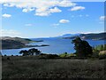
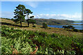
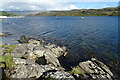
Living in PA21 2DY means occupying a specific postcode area covering a small residential cluster in Scotland. This cluster spans 20.7 hectares, offering a contained environment for residents who value defined boundaries. The area functions as a distinct pocket within the wider landscape rather than a sprawling urban zone. You will find a tight-knit community where daily life revolves around proximity to the water and local stepping stones. The postcode serves as the primary identifier for this neighbourhood, separating it from surrounding zones while maintaining close links to coastal developments. Expect a quiet existence characterised by limited density and a focus on nature. You access ferry terminals within practical reach, reinforcing the area's connection to maritime life. This small footprint dictates the rhythm of your days, with fewer distractions from broader city traffic. Homebuyers typically seek stability here, attracted by the clear limits of the land and the predictable pace of life. The location avoids major planning complexities found in denser regions, although protected designations shape future development. Your view of the area aligns with a history of conservation and controlled growth. The residential character remains consistent across the hectares, ensuring a uniform experience for occupants who appreciate a defined living space.
- Area Type
- Postcode
- Area Size
- 20.7 hectares
- Population
- Not available
- Population Density
- Not available
The property market in PA21 2DY operates within a small residential cluster defined by a specific postcode area. Information on the percentage of owner-occupied homes or the specific mix of semi-detached, terraced, and detached properties is not available in the current dataset. Buyers cannot rely on broad market trends derived from larger neighbouring zones to predict the pricing or supply dynamics of this 20.7-hectare space with certainty. The absence of accommodation type statistics means you cannot distinguish whether the stock consists primarily of traditional family homes or smaller retirement units. However, the presence of protected woodland and designation within an Area of Outstanding Natural Beauty suggests a strong demand from buyers prioritising environmental qualities. These planning constraints limit new supply, often stabilising prices against the volatility seen in unconstrained urban markets. You should expect a market where individual property characteristics carry more weight than general area-wide averages. The small size of the cluster means inventory levels remain low, requiring patience during searches. Major auction reports or open market analysis for this specific postcode may be sparse, reflecting its localised nature. prospective owners must conduct site visits to understand the specific attributes of available listings, as data aggregators lack the granularity to forecast value shifts here.
House Prices in PA21 2DY
Showing 13 properties
Energy Efficiency in PA21 2DY
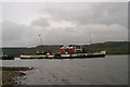
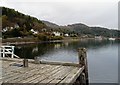
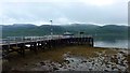
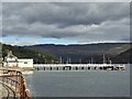
Your lifestyle in PA21 2DY is defined by immediate access to ferry infrastructure and natural features within practical reach. Four ferry terminals lie nearby, providing essential links to the wider region. You can reach Tighnabruaich Pier Ferry Terminal, Rhubodach Bute Ferry Terminal, and Colintraive Ferry Terminal, expanding your travel options beyond the local cluster. These vessels connect you to historic towns and other coastal villages, integrating travel into your weekly routine. Beyond transport, the area offers distinct planning contexts that shape your environment. The presence of protected woodland contributes to a green corridor through your neighbourhood, enhancing air quality and providing quiet walking routes. However, living in PA21 2DY also means navigating an Area of Outstanding Natural Beauty designation nearby. This status protects the landscape but imposes strict rules on new construction or renovations. You will live close to designated nature reserves and sites with specific conservation statuses, ensuring that the local scenery remains unspoiled. The lack of commercial retail blocks means your shopping trips require travel to larger villages, but the ferry access compensates by enabling coastal excursions. Daily life balances the silence of the neighbourhood with the utility of nearby maritime transport.
Amenities
Schools
| Rank | School | Type | Entry gender | Ages |
|---|
Explore more schools in this area
Go to Schools tabDemographics
The community in PA21 2DY reflects the specific profile of households residing within this small Scottish cluster. Data regarding the precise age distribution, household types, or diversity levels is not included in the current information for this postcode. Similarly, figures on home ownership percentages or accommodation types specific to this exact location are absent from the available records. Consequently, detailed demographic narratives typical of larger urban areas remain unquantifiable here. Without specific statistics on income, deprivation indices, or family structures, a deeper characterisation of the neighbourhood relies on observable planning constraints rather than census tables. You must approach community profiles with an understanding that granular data often escapes automated collection in very small residential clusters. The lack of published metrics does not diminish the reality of the people living there, but it prevents speculative descriptions of their background. Instead, focus on the physical context that shapes the community. The area contains protected woodland and sits within an Area of Outstanding Natural Beauty, influencing who chooses to live here. These planning constraints naturally filter the type of resident drawn to the location, favouring those seeking a rural or semi-rural environment over urban density. Until detailed census data becomes available, the true social makeup remains an area for personal observation rather than statistical summary.
Household Size
Accommodation Type
Tenure
Ethnic Group
Religion
Household Composition
Age
Household Deprivation
NS-SEC
Explore more demographic insights in this area
Go to Demographics tabPlanning
Planning Constraints
- Flood RiskPremium
- Ramsar Wetland SitesPremium
- Area of Outstanding Natural BeautyPremium
- Protected Nature ReservePremium
- Protected WoodlandPremium
- Crime RiskPremium