Area Overview for Carnoustie
Photos of Carnoustie


Area Information
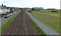
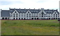
Carnoustie is a built-up area in Angus, Scotland, covering 3.1 km² on the North Sea coast. It sits approximately 14 miles east of Dundee and near Arbroath. Originally growing from a small village around linen weaving and fishing, the town accelerated its development after the 1838 Dundee-Arbroath railway arrived. The area remains a seaside resort and a dormitory town for Dundee. Its name first appeared as Carnowis in the early 1500s, though locals link the site to the Battle of Barry in 1010. This connection remains part of the local story, even if the common name derives from Scandinavian words for rock bay. You find homes in Carnoustie within a landscape defined by golf and coastal views. Carnoustie Golf Links, established in 1842, stands as a major landmark with the world's first 18-hole course. Locals raised funds in 1892 to buy the links from the Earl of Dalhousie to preserve them for the community. Simpsons Golf Shop, dating to 1883, continues to operate and serves the area's golfing tradition. Schools near Carnoustie support families in this environment. Living in Carnoustie means accessing a town with deep historical roots in textiles, malting barley, and shoemaking. Today, the economy supports these traditional bases while relying heavily on the golf industry and commuting flows to nearby Dundee.
- Area Type
- Built Up Area 250
- Area Size
- 3.1 km²
- Population
- Not available
- Population Density
- Not available
Residents of Carnoustie enjoy immediate access to essential retail and leisure facilities within practical reach. The town offers five notable retail options, including Co-op Carnoustie and Spar, which serve daily shopping needs efficiently. For transport enthusiasts, there are also five reachable railway stations, including Carnoustie Railway Station and Barry Links Railway Station. Carnoustie Golf Links remains the defining feature of local lifestyle, having hosted major tournaments since the mid-19th century. The Championship course, designed by Allan Robertson and Old Tom Morris, sits alongside the historic Old Course. You can visit Simpsons Golf Shop, which has operated since 1883, to purchase equipment or browse memorabilia. The cultural heritage is further anchored by Panbride Church, whose site dates to 1147 and current building stands from 1681. Living in Carnoustie means being close to these historical sites while maintaining a modern connection to Dundee. The area combines coastal scenery with a functional town centre. Malting barley production continues to support the local economy, adding an industrial element to the scenic environment. Dining and further leisure choices likely extend to the wider Angus region given the town's coastal position. The lifestyle is characterised by a strong connection to golf, verified history, and convenient transport links that balance quiet coastal living with commuter accessibility.
Amenities
Schools
| Rank | School | Type | Entry gender | Ages |
|---|
Explore more schools in this area
Go to Schools tabDemographics
No specific demographic data such as age profiles, household types, or diversity figures are provided for Carnoustie in the current assessment. Consequently, it is not possible to describe the precise age distribution or the mix of family sizes within the community based on available information. Similarly, data regarding home ownership levels and specific accommodation types is absent from the records. Without these figures, we cannot identify whether the population skews towards young professionals, retirees, or families, nor can we quantify the percentage of renters versus owners. The lack of statistical detail on social deprivation means we cannot evaluate the specific pressures or advantages residents face regarding income or service access. While Carnoustie functions as an open burgh with a history dating back to the mid-1700s, the specific numbers defining its modern social fabric are not included. You must rely on general observations of the built environment rather than statistical breakdowns of the population. The area's character as a resort and commuter base suggests a dynamic mix of residents, but the exact proportions remain unrecorded in the provided data. Any discussion of the community's composition must therefore stop at the level of historical development and geographical location.
Household Size
Accommodation Type
Tenure
Ethnic Group
Religion
Household Composition
Age
Household Deprivation
NS-SEC
Explore more demographic insights in this area
Go to Demographics tabPlanning
Planning Constraints
- Crime & SafetyPremium