Area Overview for Arbroath
Photos of Arbroath


Area Information
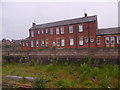
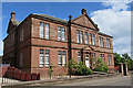
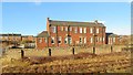
Arbroath stands as the largest town in Angus, situated approximately 17 miles northeast of Dundee on the North Sea coast. This built-up area covers 8.1 km² and is defined by its red sandstone architecture, a harbour, and deep historical ties to Scottish independence. The settlement originated outside Arbroath Abbey, which King William the Lion founded in 1178 for monks from Kelso Abbey. The town's recorded history officially began on that same date, later gaining burgh of regality status in 1178 and royal burgh status in 1599. Daily life here revolves around a distinctive coastal character shaped by the Industrial Revolution. The town grew significantly through flax, jute, fishing, and engineering industries, leaving a legacy visible in its built environment. The harbour, originally established in 1394 and enlarged in 1839, remains a prominent feature alongside the famous Arbroath smokie delicacy. You will find key landmarks including the medieval ruins of Arbroath Abbey on the High Street, a site of the 1320 Declaration of Arbroath. Other notable features encompass the Round O window, rebuilt in 1809, and a bas relief sculpture depicting town history from Pictish times to modern industries like fishing and textiles. Living in Arbroath means engaging with an urban coastal town that retains a strong connection to its heritage while functioning as a typical east coast Scottish hub.
- Area Type
- Built Up Area 250
- Area Size
- 8.1 km²
- Population
- Not available
- Population Density
- Not available
Residents of Arbroath enjoy convenient access to a variety of retail and transport amenities within practical reach of their homes. The local shopping options include Tesco Arbroath, Morrisons Hayshead, and Lidl Hayshead, providing essential groceries and daily necessities without the need for long drives. These supermarkets cater to the needs of the local population, ensuring that your weekly shop is accessible from the heart of the community. Transport links are equally well developed, with Arbroath Railway Station serving as the primary hub for the town. For those looking to travel further, Carnoustie Railway Station offers an alternative viable connection for regional trips. The presence of two major railways facilitates easy commutes to Dundee and other key Scottish cities. This network supports both daily commuting and weekend getaways, integrating Arbroath firmly into the wider travel web. Beyond commerce and transit, the area features historic landmarks that enrich daily life. The High Street is dominated by Arbroath Abbey, allowing residents to explore medieval ruins and the site of the 1320 Declaration of Arbroath easily. The harbour, originally from 1394 and enlarged in 1839, offers scenic walking routes and views of the North Sea. You will also find the Round O window, rebuilt in 1809, which serves as a unique architectural focal point. A bas relief sculpture depicting town history from Pictish times to fishing and textiles provides educational value for all ages. Living in Arbroath means having culture, convenience, and transport options all within easy reach of your doorstep.
Amenities
Schools
| Rank | School | Type | Entry gender | Ages |
|---|
Explore more schools in this area
Go to Schools tabDemographics
Every demographic section must reference specific figures from the data provided. However, the available dataset for Arbroath contains no information regarding age profiles, household types, home ownership levels, accommodation types, or ethnic diversity. There are no statistics on population density, average age, or the breakdown of buyers versus renters. Consequently, it is impossible to describe the current community structure using the exact figures required by this analysis. Regarding deprivation data, the provided information does not include any indices or measurements of social and economic disadvantage within the 8.1 km² area. Without these specific numbers, one cannot explain the context of quality of life in terms of official deprivation measures. The dataset omits all standard demographic indicators that would typically define the make-up of the population in a town of this size. Any attempt to describe the age profile or household composition would be purely speculative and outside the scope of reported facts. For a complete picture of the local population, one would normally expect data on family units, single-person households, and tenure security. Since the database currently holds no records on these attributes, this section remains silent on those specific details. The absence of data on diversity scores, average income levels, or occupational segments means we cannot assert specific trends for the residents of Arbroath at this time. We must rely solely on known historical and geographical facts rather than invented statistics.
Household Size
Accommodation Type
Tenure
Ethnic Group
Religion
Household Composition
Age
Household Deprivation
NS-SEC
Explore more demographic insights in this area
Go to Demographics tabPlanning
Planning Constraints
- Crime & SafetyPremium