Area Overview for AB43 9DG
Photos of AB43 9DG


Area Information
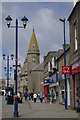
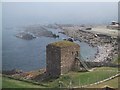
AB43 9DG represents a small, residential cluster within the larger town of Fraserburgh in Aberdeenshire, covering just 1.2 hectares. This specific postcode serves as part of a burgh of regality founded in 1588 by Sir Alexander Fraser on the Moray Firth coast. Living in this area means existing within a historic setting where the original settlement known as Faithlie was transformed into a thriving fishing town by the 1590s. The neighbourhood sits approximately 42 miles north-north-east of Aberdeen and 149 miles from Edinburgh, placing it deep within the district of Buchan. Daily life here is shaped by the town's maritime heritage, with the harbour having operated as a significant ship-building hub since the 17th century. The street scene reflects a community rooted in the past yet connected to north-east Scotland's shellfish industry today. As a fanatically coastal location, the area benefits from being sheltered by Kinnaird Head while maintaining easy access to the regional centre. Residents navigate a landscape defined by the Fraserburgh Castle landmark and a heritage centre that recognises its status as a four-star visitor attraction. This small postcode offers a slice of Fraserburgh's character without the main town's congestion, ideal for those seeking a concentrated residential environment within a historic town.
- Area Type
- Postcode
- Area Size
- 1.2 hectares
- Population
- Not available
- Population Density
- Not available
Homes in AB43 9DG exist within a 1.2-hectare footprint that functions as a residential extension to the main town. The property market here is influenced by Fraserburgh's status as a shellfish port and a historic fishing haven. Since specific data on the proportion of owner-occupied versus rental properties is not provided for this postcode, buyers cannot determine the exact balance of tenures without further research. The area falls within a region where the housing stock traditionally supports a mix of permanent residents and those working the trade. As a small cluster, the number of available properties may fluctuate with the broader Fraserburgh market, which has seen development around the harbour since the 1590s. The Town House, dating to 1855, stands as a reminder of the administrative history that shapes local property values. Older properties in this cluster may reflect the architectural evolution from the 17th-century town house to the modern era. Without data on average selling prices or rental yields, any financial assessment must be based on comparable properties in Fraserburgh. The scarcity of specific market indicators for AB43 9DG means you should treat it as an integrated part of the larger town's real estate landscape. Buyers looking at this specific area are entering a niche market typical of small postcode clusters near a major harbour.
House Prices in AB43 9DG
Showing 21 properties
| Address | Type | Beds | Baths | Last Sale Price | Last Sale Date | |
|---|---|---|---|---|---|---|
| 10 Murison Place, Fraserburgh, AB43 9DG | Terraced | 3 | 1 | - | - | |
| 1 Murison Place, Fraserburgh, AB43 9DG | Terraced | 3 | 1 | - | - | |
| 3 Murison Place, Fraserburgh, AB43 9DG | Terraced | - | - | - | - | |
| 8 Murison Place, Fraserburgh, AB43 9DG | Terraced | - | - | - | - | |
| 9 Murison Place, Fraserburgh, AB43 9DG | Semi-detached | - | - | - | - | |
| 16 Murison Place, Fraserburgh, AB43 9DG | Terraced | - | - | - | - | |
| 19 Murison Place, Fraserburgh, AB43 9DG | Terraced | - | - | - | - | |
| 18 Murison Place, Fraserburgh, AB43 9DG | Terraced | - | - | - | - | |
| 13 Murison Place, Fraserburgh, AB43 9DG | Semi-detached | - | - | - | - | |
| 17 Murison Place, Fraserburgh, AB43 9DG | house | - | - | - | - |
Energy Efficiency in AB43 9DG
Your daily life in AB43 9DG relies heavily on amenities located in the immediate town of Fraserburgh, which lies just across the road or a very short walk away. Within practical reach, you have access to five main retail outlets, including Farmfoods Fraserburgh, Co-op Albert, and Iceland Fraserburgh. These specific venues provide all the essential grocery needs and everyday items without requiring a trip into the city. The village character of this postcode means that major shopping centres are not within sight, but the necessities are concentrated nearby. A Heritage Centre, recognised as a four-star visitor attraction, sits close by for those interested in history or culture. The Glasgow and South Western Railway routes nearby historically connected the town to the rest of Scotland, although current rail access depends on the broader Fraserburgh infrastructure. For leisure, the area offers proximity to the harbour which has been instrumental to the town since the 1590s, providing a central spot for evening strolls. The renovation of the harbour with government investment covering six Scots acres created a picturesque waterfront that defines the local lifestyle. You can enjoy the sea air at Kinnaird Head without the pedestrian congestion found in larger urban developments.
Amenities
Schools
| Rank | School | Type | Entry gender | Ages |
|---|
Explore more schools in this area
Go to Schools tabDemographics
The community profile of AB43 9DG reflects the broader pattern found within Fraserburgh, though specific age bands and household type breakdowns for this 1.2-hectare cluster are not available in the current dataset. In the wider town, housing statistics show a mix of home ownership and renting, though the exact split for your specific postcode remains unlisted. You will find that the area functions as a cluster within a larger population centre, meaning the demographic makeup mirrors the surrounding neighbourhoods rather than standing entirely alone. Without access to detailed figures on occupation types or age distribution for this specific code, it is difficult to describe the precise social fabric without risking inaccuracy. The lack of granular demographic data means you must look to the general character of Fraserburgh to understand the likely residents. The town has historically relied on the fishing industry, which suggests a working population with strong local ties. Families and individuals seeking proximity to the harbour typically find homes here. The absence of specific deprivation scores or diversity metrics for this postcode prevents a detailed analysis of income levels or cultural composition. Consequently, understanding the area requires looking at the town as a whole while acknowledging the limited specificity of data regarding this precise square mile.
Household Size
Accommodation Type
Tenure
Ethnic Group
Religion
Household Composition
Age
Household Deprivation
NS-SEC
Explore more demographic insights in this area
Go to Demographics tabPlanning
Planning Constraints
- Flood RiskPremium
- Ramsar Wetland SitesPremium
- Area of Outstanding Natural BeautyPremium
- Protected Nature ReservePremium
- Protected WoodlandPremium
- Crime RiskPremium