Area Overview for YO62 7RE
Photos of YO62 7RE

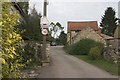
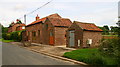

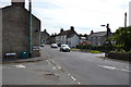
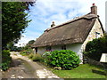

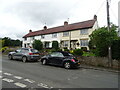
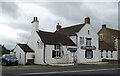
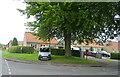
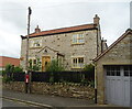
95 photos from this area
Area Information
Key information about the YO62 7RE including its size, population, and administrative classification.
- Area Type
- Postcode
- Area Size
- 9041 m²
- Population
- 2144
- Population Density
- 10 people/km²
House Prices in YO62 7RE
21
Properties
£247,417
Average Sold Price
£56,000
Lowest Price
£400,000
Highest Price
Showing 21 properties
| Address | Type | Beds | Baths | Last Sale Price | Last Sale Date | |
|---|---|---|---|---|---|---|
| Sugrajuma Cottage, Chapel Street, Nawton, YO62 7RE | Semi-detached | 3 | 2 | £395,000 | Nov 2023 | |
| Rose Garth, Chapel Street, Nawton, YO62 7RE | Semi-detached | 2 | 1 | £250,000 | Aug 2023 | |
| 5 Chapel Street, Nawton, YO62 7RE | house | 3 | 2 | £325,000 | Aug 2022 | |
| Chapel Bungalow, Chapel Street, Nawton, YO62 7RE | Bungalow | 2 | 1 | £210,000 | Nov 2020 | |
| Bellaby House, Chapel Street, Nawton, YO62 7RE | Terraced | - | - | £385,000 | Oct 2020 | |
| The Sheilings, Chapel Street, Nawton, YO62 7RE | Semi-detached | 4 | 2 | £400,000 | Jan 2020 | |
| 3 Chapel Street, Nawton, YO62 7RE | Terraced | - | - | £190,000 | Jul 2013 | |
| Wolds View, Chapel Street, Nawton, YO62 7RE | Semi-detached | 3 | 1 | £239,000 | Jun 2013 | |
| The Bield, Chapel Street, Nawton, YO62 7RE | Semi-detached | - | - | £270,000 | Aug 2009 | |
| Craignish, Chapel Street, Nawton, YO62 7RE | Semi-detached | - | - | £164,000 | Jun 2001 |
Page 1 of 3
Energy Efficiency in YO62 7RE
Amenities
Schools
| Rank | School | Type | Entry gender | Ages |
|---|
Explore more schools in this area
Go to Schools tabDemographics
Household Size
Two person
most common
Accommodation Type
Houses
most common
Tenure
59
majority
Ethnic Group
White
most common
Religion
N/A
most common
Household Composition
N/A
most common
Age
47
median
Adults (30-64 years)
most common
Household Deprivation
N/A
with no deprivation
NS-SEC
34
in Lower managerial occupations
Explore more demographic insights in this area
Go to Demographics tabPlanning
Planning Constraints
- Flood RiskPremium
- Ramsar Wetland SitesPremium
- Area of Outstanding Natural BeautyPremium
- Protected Nature ReservePremium
- Protected WoodlandPremium