Area Overview for TS9 6AA
Photos of TS9 6AA


75 photos from this area
Area Information
Key information about the TS9 6AA including its size, population, and administrative classification.
- Area Type
- Postcode
- Area Size
- 9190 m²
- Population
- 1671
- Population Density
- 208 people/km²
House Prices in TS9 6AA
6
Properties
£250,825
Average Sold Price
£169,950
Lowest Price
£345,000
Highest Price
Showing 6 properties
| Address | Type | Beds | Baths | Last Sale Price | Last Sale Date | |
|---|---|---|---|---|---|---|
| 11 Guisborough Road, Great Ayton, TS9 6AA | house | 2 | 1 | £175,000 | Jan 2025 | |
| 7 Guisborough Road, Great Ayton, TS9 6AA | Terraced | 2 | 1 | £245,000 | Feb 2024 | |
| 1 Guisborough Road, Great Ayton, TS9 6AA | Retail | 3 | 2 | £345,000 | May 2022 | |
| 9 Guisborough Road, Great Ayton, TS9 6AA | house | - | - | £169,950 | Nov 2017 | |
| Glebe Meadow, 15 Guisborough Road, Great Ayton, TS9 6AA | Bungalow | 3 | - | £270,000 | Aug 2016 | |
| 13 Guisborough Road, Great Ayton, TS9 6AA | Detached | 4 | 2 | £300,000 | Apr 2002 |
Energy Efficiency in TS9 6AA
Amenities
Schools
| Rank | School | Type | Entry gender | Ages |
|---|
Explore more schools in this area
Go to Schools tabDemographics
Household Size
Two person
most common
Accommodation Type
Houses
most common
Tenure
88
majority
Ethnic Group
White
most common
Religion
N/A
most common
Household Composition
N/A
most common
Age
47
median
Elderly (65+ years)
most common
Household Deprivation
N/A
with no deprivation
NS-SEC
46
in Lower managerial occupations
Explore more demographic insights in this area
Go to Demographics tabPlanning
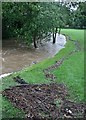
Planning Constraints
- Flood RiskPremium
- Ramsar Wetland SitesPremium
- Area of Outstanding Natural BeautyPremium
- Protected Nature ReservePremium
- Protected WoodlandPremium