Area Overview for S8 0UQ
Photos of S8 0UQ
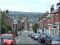
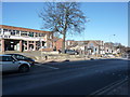
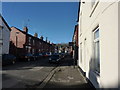
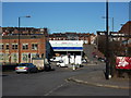
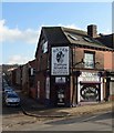
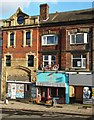
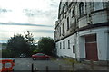
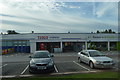
99 photos from this area
Area Information
Key information about the S8 0UQ including its size, population, and administrative classification.
- Area Type
- Postcode
- Area Size
- 3973 m²
- Population
- 1611
- Population Density
- 7897 people/km²
House Prices in S8 0UQ
34
Properties
£137,043
Average Sold Price
£40,000
Lowest Price
£231,300
Highest Price
Showing 34 properties
| Address | Type | Beds | Baths | Last Sale Price | Last Sale Date | |
|---|---|---|---|---|---|---|
| 19 Langdale Road, Sheffield, S8 0UQ | Terraced | 2 | 1 | £182,000 | Apr 2024 | |
| 17 Langdale Road, Sheffield, S8 0UQ | Terraced | 2 | 1 | £184,000 | Jun 2023 | |
| 8 Langdale Road, Sheffield, S8 0UQ | house | - | - | £165,000 | May 2023 | |
| 21 Langdale Road, Sheffield, S8 0UQ | Terraced | 2 | 1 | £191,000 | Nov 2022 | |
| 20 Langdale Road, Sheffield, S8 0UQ | Terraced | 2 | 1 | £231,300 | Aug 2022 | |
| 33 Langdale Road, Sheffield, S8 0UQ | Retail | 2 | 1 | £205,000 | Jul 2022 | |
| 25 Langdale Road, Sheffield, S8 0UQ | Terraced | 2 | 1 | £186,568 | Jul 2022 | |
| 35 Langdale Road, Sheffield, S8 0UQ | Terraced | 3 | 1 | £130,500 | Aug 2020 | |
| 16 Langdale Road, Sheffield, S8 0UQ | Terraced | 2 | 1 | £142,000 | Mar 2019 | |
| 14 Langdale Road, Sheffield, S8 0UQ | house | - | - | £134,450 | Feb 2018 |
Page 1 of 4
Energy Efficiency in S8 0UQ
Amenities
Schools
| Rank | School | Type | Entry gender | Ages |
|---|
Explore more schools in this area
Go to Schools tabDemographics
Household Size
Two person
most common
Accommodation Type
Houses
most common
Tenure
61
majority
Ethnic Group
White
most common
Religion
N/A
most common
Household Composition
N/A
most common
Age
47
median
Adults (30-64 years)
most common
Household Deprivation
N/A
with no deprivation
NS-SEC
42
in Lower managerial occupations
Explore more demographic insights in this area
Go to Demographics tabPlanning
Planning Constraints
- Flood RiskPremium
- Ramsar Wetland SitesPremium
- Area of Outstanding Natural BeautyPremium
- Protected Nature ReservePremium
- Protected WoodlandPremium